Property Record
163 E State St, Johnstown, NY 12095


Save to a Folder
{{folder.Name}}
{{folder.ListingIds.length}} Properties
{{folder.ListingIds.length}} Property
Create a New Folder
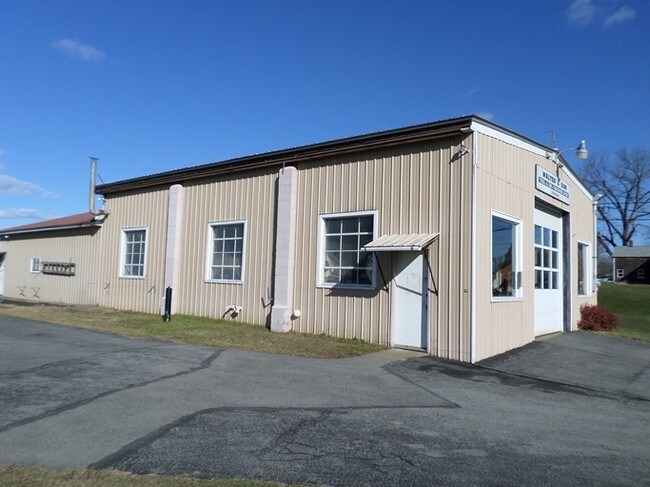
Property Detail
163 E State St
172800-134-008-0002-011-000-0000
FULTON
Storesoffices
New York
R1
11.000
2025
1 AC
2025
Fulton County
971200
Albany/Schenectady/Troy
3,024 SF
Gloversville, NY
NEARBY LISTINGS FOR SALE OR LEASE
DEMOGRAPHICS near 163 E State St
1 mile
3 mile
5 mile
2025 Total Population
2,972
16,935
26,499
2030 Population
2,891
16,408
25,935
Pop Growth 2025-2030
(2.73%)
(3.11%)
(2.13%)
Average Age
44
42
42
2025 Total Households
1,217
7,180
11,280
HH Growth 2025-2030
(2.63%)
(3.19%)
(2.15%)
Median Household Inc
$70,552
$54,773
$58,822
Avg Household Size
2.20
2.20
2.20
2025 Avg HH Vehicles
2.00
2.00
2.00
Median Home Value
$144,324
$126,522
$145,740
Median Year Built
1948
1947
1949
Nearby Places
Map Layers
Map Styles
 Street
 Aerial
Layers
 Traffic
 Biking
Places
Listings with unknown addresses are not visible on the map
- Restaurants
- Banks
- Shops
- Fitness
- Groceries
SALE & LEASE HISTORY
LISTING DATE
SALE/LEASE

Jun 20, 2019
For Sale
Nearby Properties
Address
Land Use
TOTAL SIZE
Lot Size
Zoning
Address
Land Use
TOTAL SIZE
Lot Size
Zoning
155,394 SF
83.80 AC
R2
Address
Land Use
TOTAL SIZE
Lot Size
Zoning
154,349 SF
10.60 AC
R1
Address
Land Use
TOTAL SIZE
Lot Size
Zoning
156,746 SF
31.20 AC
M
Address
Land Use
TOTAL SIZE
Lot Size
Zoning
Address
Land Use
TOTAL SIZE
Lot Size
Zoning
Address
Land Use
TOTAL SIZE
Lot Size
Zoning
72,560 SF
2.10 AC
C
Address
Land Use
TOTAL SIZE
Lot Size
Zoning
Address
Land Use
TOTAL SIZE
Lot Size
Zoning
Address
Land Use
TOTAL SIZE
Lot Size
Zoning
67,650 SF
1.55 AC
C
Address
Land Use
TOTAL SIZE
Lot Size
Zoning
20,030 SF
3.60 AC
C
Address
Land Use
TOTAL SIZE
Lot Size
Zoning
36,450 SF
4.70 AC
R1
Address
Land Use
TOTAL SIZE
Lot Size
Zoning
36,755 SF
1.70 AC
RC
Address
Land Use
TOTAL SIZE
Lot Size
Zoning
2.30 AC
M1
Address
Land Use
TOTAL SIZE
Lot Size
Zoning
135,278 SF
13.70 AC
C1
Address
Land Use
TOTAL SIZE
Lot Size
Zoning
9,074 SF
30.80 AC
C
Address
Land Use
TOTAL SIZE
Lot Size
Zoning
44,128 SF
5 AC
C1
Address
Land Use
TOTAL SIZE
Lot Size
Zoning
54,164 SF
25 AC
R1
Address
Land Use
TOTAL SIZE
Lot Size
Zoning
43,891 SF
5.63 AC
C
Address
Land Use
TOTAL SIZE
Lot Size
Zoning
29,848 SF
3.30 AC
R1
Address
Land Use
TOTAL SIZE
Lot Size
Zoning
570,000 SF
62.60 AC
I
Address
Land Use
TOTAL SIZE
Lot Size
Zoning
34,758 SF
0.93 AC
RC
Address
Land Use
TOTAL SIZE
Lot Size
Zoning
53,323 SF
91.80 AC
R1
Address
Land Use
TOTAL SIZE
Lot Size
Zoning
46,426 SF
7.50 AC
R2
Address
Land Use
TOTAL SIZE
Lot Size
Zoning
33,260 SF
2.86 AC
C
Address
Land Use
TOTAL SIZE
Lot Size
Zoning
205,369 SF
22.50 AC
M1
Address
Land Use
TOTAL SIZE
Lot Size
Zoning
5,304 SF
3.20 AC
M2
Address
Land Use
TOTAL SIZE
Lot Size
Zoning
154.80 AC
R2
Address
Land Use
TOTAL SIZE
Lot Size
Zoning
7,458 SF
63 AC
C
Address
Land Use
TOTAL SIZE
Lot Size
Zoning
5.10 AC
R1
Address
Land Use
TOTAL SIZE
Lot Size
Zoning
14,820 SF
3.80 AC
C2
The World's #1 Commercial Real Estate Marketplace
Connect with us
© 2026 CoStar Group
The information above has been obtained from sources believed reliable. While we do not doubt its accuracy we have not verified it and make no guarantee, warranty or representation about it. It is your responsibility to independently confirm its accuracy and completeness. Any projections, opinions, assumptions, or estimates used are for example only and do not represent the current or future performance of the property. The value of this transaction to you depends on tax and other factors which should be evaluated by your tax, financial, and legal advisors. You and your advisors should conduct a careful, independent investigation of the property to determine to your satisfaction the suitability of the property for your needs.