Property Record
1630 Birchwood Ave, Des Plaines, IL 60018
NEARBY LISTINGS FOR SALE OR LEASE
Property Detail
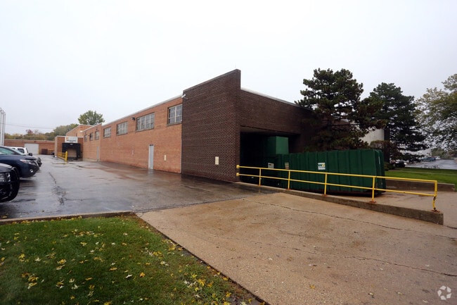
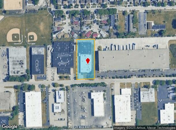
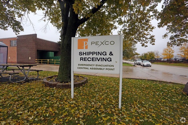
1630 Birchwood Ave
Chicago-Naperville-Elgin, IL-IN-WI
Touhy Mannheim Industrial Sub Unit2
09-28-300-009-0000
(TOUHY) (MANNHEIM) (INDUSTRIAL) SUB (UNIT2) IN WH SW SEC28 & NE SE SEC29 NE SE SEC 29-41-12
Industrialgeneral
Cook
X
Illinois
17031C0219J
5,6
2023
1.64 AC
2024
O'Hare
806502
Chicago
DEMOGRAPHICS near 1630 Birchwood Ave
1 Mile
3 Mile
5 Mile
2024 Total Population
13,153
105,445
311,565
2029 Population
12,736
102,322
302,112
Pop Growth 2024-2029
(3.17%)
(2.96%)
(3.03%)
Average Age
40
42
42
2024 Total Households
4,387
39,558
118,701
HH Growth 2024-2029
(3.51%)
(3.20%)
(3.34%)
Median Household Inc
$75,359
$82,402
$81,767
Avg Household Size
2.90
2.60
2.50
2024 Avg HH Vehicles
2.00
2.00
2.00
Median Home Value
$281,696
$322,290
$339,410
Median Year Built
1958
1966
1965
Nearby Places
Map Layers
Map Styles
 Street
 Aerial
- Restaurants
- Banks
- Shops
- Fitness
- Groceries
PUBLIC TRANSPORTATION
COMMUTER RAIL
O'Hare Transfer Station (North Central Service - Northeast Illinois Regional Commuter Railroad (Metra))
DRIVE
WALK
Distance
O'Hare Transfer Station (North Central Service - Northeast Illinois Regional Commuter Railroad (Metra))
5 min
2.0 mi
Des Plaines Station (Union Pacific Northwest Line - Northeast Illinois Regional Commuter Railroad (Metra))
DRIVE
WALK
Distance
Des Plaines Station (Union Pacific Northwest Line - Northeast Illinois Regional Commuter Railroad (Metra))
5 min
2.4 mi
AIRPORT
Chicago O'Hare International
DRIVE
WALK
Distance
Chicago O'Hare International
9 min
4.4 mi
Chicago Midway International
DRIVE
WALK
Distance
Chicago Midway International
39 min
21.9 mi
Nearby Properties
Address
Land Use
TOTAL SIZE
Lot Size
Zoning
Address
Land Use
TOTAL SIZE
Lot Size
Zoning
1,127,595 SF
Address
Land Use
TOTAL SIZE
Lot Size
Zoning
733,433 SF
10.93 AC
Address
Land Use
TOTAL SIZE
Lot Size
Zoning
833,077 SF
11.90 AC
Address
Land Use
TOTAL SIZE
Lot Size
Zoning
Address
Land Use
TOTAL SIZE
Lot Size
Zoning
555,681 SF
7.36 AC
PD 340
Address
Land Use
TOTAL SIZE
Lot Size
Zoning
380,895 SF
5.36 AC
Address
Land Use
TOTAL SIZE
Lot Size
Zoning
2.62 AC
Address
Land Use
TOTAL SIZE
Lot Size
Zoning
Address
Land Use
TOTAL SIZE
Lot Size
Zoning
248,726 SF
11.79 AC
PD 44
Address
Land Use
TOTAL SIZE
Lot Size
Zoning
1,160,629 SF
Address
Land Use
TOTAL SIZE
Lot Size
Zoning
221,692 SF
2.12 AC
Address
Land Use
TOTAL SIZE
Lot Size
Zoning
413,338 SF
23.92 AC
Address
Land Use
TOTAL SIZE
Lot Size
Zoning
246,000 SF
2.29 AC
PD 340
Address
Land Use
TOTAL SIZE
Lot Size
Zoning
334,000 SF
1.77 AC
Address
Land Use
TOTAL SIZE
Lot Size
Zoning
Address
Land Use
TOTAL SIZE
Lot Size
Zoning
Address
Land Use
TOTAL SIZE
Lot Size
Zoning
121,117 SF
3.09 AC
Address
Land Use
TOTAL SIZE
Lot Size
Zoning
286,801 SF
0.94 AC
Address
Land Use
TOTAL SIZE
Lot Size
Zoning
508,246 SF
32.81 AC
Address
Land Use
TOTAL SIZE
Lot Size
Zoning
372,935 SF
7.34 AC
Address
Land Use
TOTAL SIZE
Lot Size
Zoning
1.23 AC
Address
Land Use
TOTAL SIZE
Lot Size
Zoning
270,512 SF
2.26 AC
Address
Land Use
TOTAL SIZE
Lot Size
Zoning
322,805 SF
Address
Land Use
TOTAL SIZE
Lot Size
Zoning
1.30 AC
Address
Land Use
TOTAL SIZE
Lot Size
Zoning
249,433 SF
4.57 AC
Address
Land Use
TOTAL SIZE
Lot Size
Zoning
869,120 SF
2.81 AC
Address
Land Use
TOTAL SIZE
Lot Size
Zoning
368,725 SF
4.46 AC
Address
Land Use
TOTAL SIZE
Lot Size
Zoning
3.84 AC
Address
Land Use
TOTAL SIZE
Lot Size
Zoning
378,525 SF
0.11 AC
Address
Land Use
TOTAL SIZE
Lot Size
Zoning
298,747 SF
5.11 AC
The World's #1 Commercial Real Estate Marketplace
Connect with us
© 2025 CoStar Group
The information above has been obtained from sources believed reliable. While we do not doubt its accuracy we have not verified it and make no guarantee, warranty or representation about it. It is your responsibility to independently confirm its accuracy and completeness. Any projections, opinions, assumptions, or estimates used are for example only and do not represent the current or future performance of the property. The value of this transaction to you depends on tax and other factors which should be evaluated by your tax, financial, and legal advisors. You and your advisors should conduct a careful, independent investigation of the property to determine to your satisfaction the suitability of the property for your needs.