Property Record
1630 Coshocton Ave, Mount Vernon, OH 43050


Save to a Folder
{{folder.Name}}
{{folder.ListingIds.length}} Properties
{{folder.ListingIds.length}} Property
Create a New Folder
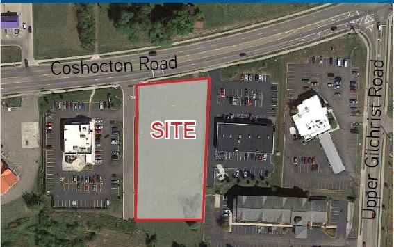
Property Detail
1630 Coshocton Ave
Mount Vernon, OH
12 7 3 CENTER E PT NW SECT 24 1.694AC
66-09757.002
KNOX
Storebuilding
Ohio
B and X Area of moderate flood hazard, usually the area between the limits of the 100-year and 500-year floods.
1.69 AC
2025
Ohio North Area
2025
Other Market Areas
007500
NEARBY LISTINGS FOR SALE OR LEASE
-
-
View all Mount Vernon listings for sale on LoopNet.com
DEMOGRAPHICS near 1630 Coshocton Ave
1 mile
3 mile
5 mile
2025 Total Population
2,436
19,335
30,273
2030 Population
2,497
19,633
30,852
Pop Growth 2025-2030
+ 2.50%
+ 1.54%
+ 1.91%
Average Age
49
41
41
2025 Total Households
1,098
7,538
11,666
HH Growth 2025-2030
+ 2.73%
+ 1.64%
+ 2.02%
Median Household Inc
$56,844
$59,176
$65,857
Avg Household Size
1.90
2.20
2.30
2025 Avg HH Vehicles
2.00
2.00
2.00
Median Home Value
$221,084
$192,099
$207,330
Median Year Built
1983
1963
1966
Nearby Places
Map Layers
Map Styles
 Street
 Aerial
Layers
 Traffic
 Biking
Places
Listings with unknown addresses are not visible on the map
- Restaurants
- Banks
- Shops
- Fitness
- Groceries
PUBLIC TRANSPORTATION
AIRPORT
John Glenn Columbus International
Drive
Walk
Distance
John Glenn Columbus International
62 min
46.6 mi
SALE & LEASE HISTORY
LISTING DATE
SALE/LEASE

Sep 24, 2016
For Sale
Jan 14, 2020
For Sale
Nearby Properties
Address
Land Use
TOTAL SIZE
Lot Size
Zoning
Address
Land Use
TOTAL SIZE
Lot Size
Zoning
7,223 SF
42.17 AC
Address
Land Use
TOTAL SIZE
Lot Size
Zoning
6,856 SF
106.31 AC
Address
Land Use
TOTAL SIZE
Lot Size
Zoning
118,756 SF
80 AC
Address
Land Use
TOTAL SIZE
Lot Size
Zoning
95,818 SF
4.51 AC
Address
Land Use
TOTAL SIZE
Lot Size
Zoning
4,238 SF
11.38 AC
Address
Land Use
TOTAL SIZE
Lot Size
Zoning
88,043 SF
11.54 AC
Address
Land Use
TOTAL SIZE
Lot Size
Zoning
34,560 SF
Address
Land Use
TOTAL SIZE
Lot Size
Zoning
14,968 SF
19.69 AC
Address
Land Use
TOTAL SIZE
Lot Size
Zoning
Address
Land Use
TOTAL SIZE
Lot Size
Zoning
120,513 SF
22.50 AC
Address
Land Use
TOTAL SIZE
Lot Size
Zoning
48,700 SF
12.06 AC
Address
Land Use
TOTAL SIZE
Lot Size
Zoning
1,303 SF
0.10 AC
Address
Land Use
TOTAL SIZE
Lot Size
Zoning
126,416 SF
21.20 AC
Address
Land Use
TOTAL SIZE
Lot Size
Zoning
102,480 SF
18.21 AC
Address
Land Use
TOTAL SIZE
Lot Size
Zoning
32,169 SF
3.13 AC
Address
Land Use
TOTAL SIZE
Lot Size
Zoning
2,630 SF
7.14 AC
Address
Land Use
TOTAL SIZE
Lot Size
Zoning
Address
Land Use
TOTAL SIZE
Lot Size
Zoning
56,768 SF
62.58 AC
Address
Land Use
TOTAL SIZE
Lot Size
Zoning
5,613 SF
15.22 AC
Address
Land Use
TOTAL SIZE
Lot Size
Zoning
18,328 SF
9.18 AC
Address
Land Use
TOTAL SIZE
Lot Size
Zoning
57,271 SF
102.03 AC
Address
Land Use
TOTAL SIZE
Lot Size
Zoning
28,872 SF
0.14 AC
Address
Land Use
TOTAL SIZE
Lot Size
Zoning
95,336 SF
12.99 AC
Address
Land Use
TOTAL SIZE
Lot Size
Zoning
65,802 SF
1.03 AC
Address
Land Use
TOTAL SIZE
Lot Size
Zoning
47,923 SF
7.38 AC
Address
Land Use
TOTAL SIZE
Lot Size
Zoning
38,181 SF
7.26 AC
Address
Land Use
TOTAL SIZE
Lot Size
Zoning
34,857 SF
0.99 AC
Address
Land Use
TOTAL SIZE
Lot Size
Zoning
21,399 SF
0.25 AC
Address
Land Use
TOTAL SIZE
Lot Size
Zoning
17,556 SF
8 AC
Address
Land Use
TOTAL SIZE
Lot Size
Zoning
48,821 SF
0.20 AC
The World's #1 Commercial Real Estate Marketplace
Connect with us
© 2026 CoStar Group
The information above has been obtained from sources believed reliable. While we do not doubt its accuracy we have not verified it and make no guarantee, warranty or representation about it. It is your responsibility to independently confirm its accuracy and completeness. Any projections, opinions, assumptions, or estimates used are for example only and do not represent the current or future performance of the property. The value of this transaction to you depends on tax and other factors which should be evaluated by your tax, financial, and legal advisors. You and your advisors should conduct a careful, independent investigation of the property to determine to your satisfaction the suitability of the property for your needs.