Property Record
1630 N Fifth St, Madison, GA 30650


Current Lease Availabilities
NEARBY LISTINGS FOR SALE OR LEASE
Property Detail
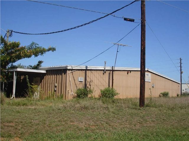
1630 N Fifth St
Atlanta-Sandy Springs-Roswell, GA
Madison I1 Airport Ind Acre
035082000
JDR HOLDINGS
Manufacturinglight
Morgan
X
Georgia
13211C0205B
55
2025
5.77 AC
2025
Atlanta East
010301
Other Market Areas
75,956 SF
DEMOGRAPHICS near 1630 N Fifth St
1 Mile
3 Mile
5 Mile
2024 Total Population
2,034
6,765
8,697
2029 Population
2,286
7,550
9,710
Pop Growth 2024-2029
+ 12.39%
+ 11.60%
+ 11.65%
Average Age
42
41
41
2024 Total Households
797
2,571
3,277
HH Growth 2024-2029
+ 12.42%
+ 11.59%
+ 11.63%
Median Household Inc
$66,283
$73,558
$71,640
Avg Household Size
2.40
2.50
2.50
2024 Avg HH Vehicles
2.00
2.00
2.00
Median Home Value
$304,902
$350,940
$343,137
Median Year Built
1986
1984
1985
Nearby Places
Map Layers
Map Styles
 Street
 Aerial
- Restaurants
- Banks
- Shops
- Fitness
- Groceries
Nearby Properties
Address
Land Use
TOTAL SIZE
Lot Size
Zoning
Address
Land Use
TOTAL SIZE
Lot Size
Zoning
115,369 SF
79.11 AC
R
Address
Land Use
TOTAL SIZE
Lot Size
Zoning
74,434 SF
22.42 AC
R
Address
Land Use
TOTAL SIZE
Lot Size
Zoning
916 SF
23 AC
R
Address
Land Use
TOTAL SIZE
Lot Size
Zoning
110,017 SF
17.61 AC
C3
Address
Land Use
TOTAL SIZE
Lot Size
Zoning
48,108 SF
21.78 AC
R1
Address
Land Use
TOTAL SIZE
Lot Size
Zoning
447,780 SF
65 AC
I2
Address
Land Use
TOTAL SIZE
Lot Size
Zoning
17,100 SF
0.46 AC
C1
Address
Land Use
TOTAL SIZE
Lot Size
Zoning
17,326 SF
2.28 AC
R1
Address
Land Use
TOTAL SIZE
Lot Size
Zoning
2,426 SF
28.08 AC
PPD
Address
Land Use
TOTAL SIZE
Lot Size
Zoning
177,950 SF
19.91 AC
I1
Address
Land Use
TOTAL SIZE
Lot Size
Zoning
6,192 SF
6.24 AC
R2
Address
Land Use
TOTAL SIZE
Lot Size
Zoning
29,289 SF
5.83 AC
P1
Address
Land Use
TOTAL SIZE
Lot Size
Zoning
156,496 SF
5.58 AC
I1
Address
Land Use
TOTAL SIZE
Lot Size
Zoning
61,525 SF
12.12 AC
C3
Address
Land Use
TOTAL SIZE
Lot Size
Zoning
329,470 SF
27.51 AC
I1
Address
Land Use
TOTAL SIZE
Lot Size
Zoning
8,332 SF
1.20 AC
P2 / PRD
Address
Land Use
TOTAL SIZE
Lot Size
Zoning
2,013 SF
9.93 AC
R8 / PRD
Address
Land Use
TOTAL SIZE
Lot Size
Zoning
8,496 SF
9.96 AC
R8 / PRD
Address
Land Use
TOTAL SIZE
Lot Size
Zoning
21,345 SF
1.47 AC
R1
Address
Land Use
TOTAL SIZE
Lot Size
Zoning
109,124 SF
16.03 AC
I2
Address
Land Use
TOTAL SIZE
Lot Size
Zoning
167,557 SF
8.86 AC
I1
Address
Land Use
TOTAL SIZE
Lot Size
Zoning
1,620 SF
7.99 AC
R6
Address
Land Use
TOTAL SIZE
Lot Size
Zoning
2,176 SF
15.51 AC
PRD
Address
Land Use
TOTAL SIZE
Lot Size
Zoning
548 SF
608.86 AC
AR
Address
Land Use
TOTAL SIZE
Lot Size
Zoning
2,286 SF
5.96 AC
R8 / PRD
Address
Land Use
TOTAL SIZE
Lot Size
Zoning
2,080 SF
88.16 AC
R1
Address
Land Use
TOTAL SIZE
Lot Size
Zoning
97,259 SF
4.17 AC
I1
Address
Land Use
TOTAL SIZE
Lot Size
Zoning
2,800 SF
111.97 AC
I2
Address
Land Use
TOTAL SIZE
Lot Size
Zoning
2,000 SF
0.79 AC
R1
Address
Land Use
TOTAL SIZE
Lot Size
Zoning
9,142 SF
2.23 AC
R1
The World's #1 Commercial Real Estate Marketplace
Connect with us
© 2026 CoStar Group
The information above has been obtained from sources believed reliable. While we do not doubt its accuracy we have not verified it and make no guarantee, warranty or representation about it. It is your responsibility to independently confirm its accuracy and completeness. Any projections, opinions, assumptions, or estimates used are for example only and do not represent the current or future performance of the property. The value of this transaction to you depends on tax and other factors which should be evaluated by your tax, financial, and legal advisors. You and your advisors should conduct a careful, independent investigation of the property to determine to your satisfaction the suitability of the property for your needs.