Property Record
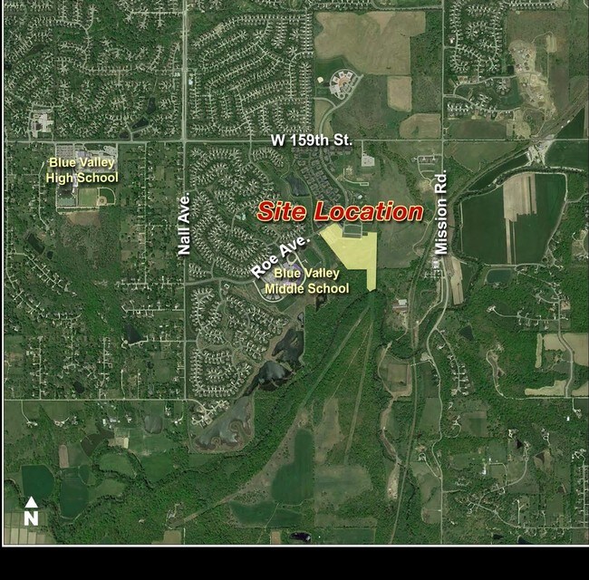
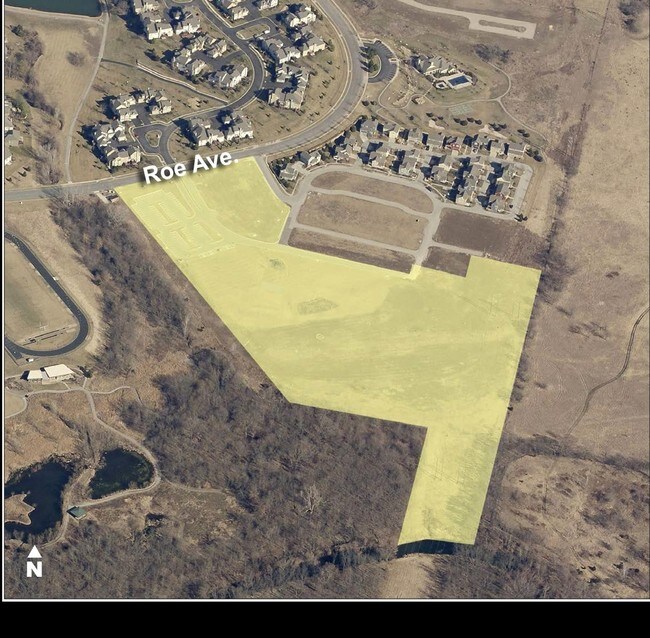
16301 Roe Ave, Stilwell, KS 66085

Property Detail
16301 Roe Ave
NP08050000-0001
CAMBRIDGE CHURCH LT 1 & 16-14-25 PT NE1/4 & PT SE1/4 BG 1337.70 W SE CR NE1/4 S ALG E/L W 1/2 SE1/4 400 SW 81.75 & 66.15 NW 85.58 N 403.44 W 360.89 NW 978.01 NE 402.55 SE 134.95 & 79.96S 162.66 E 379.50 N 64.22 E147 N 61.17 E 203.22 TO E/LW 1/2 NE1/4
Religious
JOHNSON
RP-4
Kansas
AE The base floodplain where base flood elevations are provided. AE Zones are now used on new format FIRMs instead of A1-A30 Zones.
1
2024
16.78 AC
2025
South Johnson County
053803
Kansas City
8,364 SF
Kansas City, MO-KS
NEARBY LISTINGS FOR SALE OR LEASE
DEMOGRAPHICS near 16301 Roe Ave
1 mile
3 mile
5 mile
2025 Total Population
5,703
37,993
99,080
2030 Population
5,976
39,459
102,585
Pop Growth 2025-2030
+ 4.79%
+ 3.86%
+ 3.54%
Average Age
40
40
41
2025 Total Households
1,936
13,288
36,379
HH Growth 2025-2030
+ 4.86%
+ 3.95%
+ 3.63%
Median Household Inc
$164,136
$149,909
$142,566
Avg Household Size
2.90
2.80
2.70
2025 Avg HH Vehicles
2.00
2.00
2.00
Median Home Value
$555,736
$575,756
$615,844
Median Year Built
2003
2001
1999
Nearby Places
Map Layers
Map Styles
 Street
 Aerial
Layers
 Traffic
 Biking
Places
Listings with unknown addresses are not visible on the map
- Restaurants
- Banks
- Shops
- Fitness
- Groceries
Nearby Properties
Address
Land Use
TOTAL SIZE
Lot Size
Zoning
Address
Land Use
TOTAL SIZE
Lot Size
Zoning
195,983 SF
20.88 AC
CP-2
Address
Land Use
TOTAL SIZE
Lot Size
Zoning
239,520 SF
35.28 AC
R-1BJ
Address
Land Use
TOTAL SIZE
Lot Size
Zoning
184,524 SF
33.20 AC
AG
Address
Land Use
TOTAL SIZE
Lot Size
Zoning
254,535 SF
11.97 AC
RN1
Address
Land Use
TOTAL SIZE
Lot Size
Zoning
122,491 SF
19.30 AC
R-1
Address
Land Use
TOTAL SIZE
Lot Size
Zoning
185,906 SF
34.09 AC
R-1
Address
Land Use
TOTAL SIZE
Lot Size
Zoning
26,022 SF
109.48 AC
IP-2J
Address
Land Use
TOTAL SIZE
Lot Size
Zoning
102,411 SF
17.02 AC
AG
Address
Land Use
TOTAL SIZE
Lot Size
Zoning
66,577 SF
7.88 AC
R-1
Address
Land Use
TOTAL SIZE
Lot Size
Zoning
76,942 SF
15.10 AC
R-1
Address
Land Use
TOTAL SIZE
Lot Size
Zoning
72,184 SF
9.53 AC
AG
Address
Land Use
TOTAL SIZE
Lot Size
Zoning
45,775 SF
17.05 AC
BP
Address
Land Use
TOTAL SIZE
Lot Size
Zoning
214,909 SF
20.52 AC
CP-2
Address
Land Use
TOTAL SIZE
Lot Size
Zoning
69,077 SF
17.90 AC
R-1
Address
Land Use
TOTAL SIZE
Lot Size
Zoning
59,770 SF
8.88 AC
CP-2
Address
Land Use
TOTAL SIZE
Lot Size
Zoning
9,508 SF
8.29 AC
RP-1
Address
Land Use
TOTAL SIZE
Lot Size
Zoning
67,523 SF
11.95 AC
R-1
Address
Land Use
TOTAL SIZE
Lot Size
Zoning
73,251 SF
29.96 AC
RP-3
Address
Land Use
TOTAL SIZE
Lot Size
Zoning
50,835 SF
5.80 AC
R-1BJ
Address
Land Use
TOTAL SIZE
Lot Size
Zoning
31,890 SF
2.38 AC
R-1
Address
Land Use
TOTAL SIZE
Lot Size
Zoning
32,158 SF
3.07 AC
RRJ
Address
Land Use
TOTAL SIZE
Lot Size
Zoning
22,962 SF
5.37 AC
CP-2
Address
Land Use
TOTAL SIZE
Lot Size
Zoning
62,380 SF
7.67 AC
R-1
Address
Land Use
TOTAL SIZE
Lot Size
Zoning
97,736 SF
12.73 AC
RP-5
Address
Land Use
TOTAL SIZE
Lot Size
Zoning
44,963 SF
6.96 AC
RP-5
Address
Land Use
TOTAL SIZE
Lot Size
Zoning
23,081 SF
4.34 AC
PEC-3J
Address
Land Use
TOTAL SIZE
Lot Size
Zoning
7,783 SF
4.64 AC
REC
Address
Land Use
TOTAL SIZE
Lot Size
Zoning
190,937 SF
21.83 AC
CP-2
Address
Land Use
TOTAL SIZE
Lot Size
Zoning
17,948 SF
2.20 AC
PRB-3J
Address
Land Use
TOTAL SIZE
Lot Size
Zoning
24,609 SF
8.08 AC
CP-2
The World's #1 Commercial Real Estate Marketplace
Connect with us
© 2026 CoStar Group
The information above has been obtained from sources believed reliable. While we do not doubt its accuracy we have not verified it and make no guarantee, warranty or representation about it. It is your responsibility to independently confirm its accuracy and completeness. Any projections, opinions, assumptions, or estimates used are for example only and do not represent the current or future performance of the property. The value of this transaction to you depends on tax and other factors which should be evaluated by your tax, financial, and legal advisors. You and your advisors should conduct a careful, independent investigation of the property to determine to your satisfaction the suitability of the property for your needs.