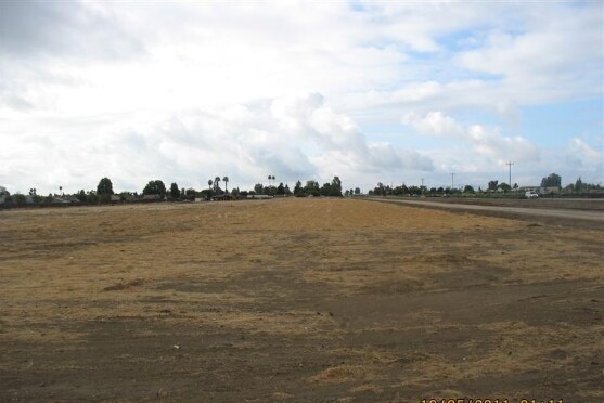
Property Record
1631 Hosking Ave, Bakersfield, CA 93307

NEARBY LISTINGS FOR SALE OR LEASE
Property Detail
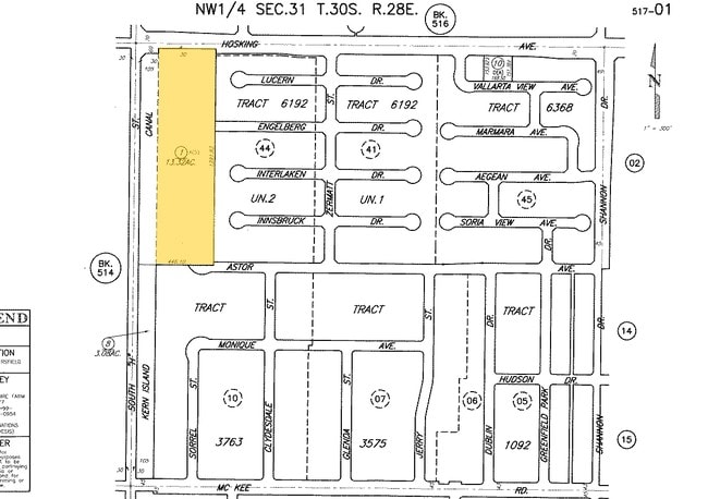
1631 Hosking Ave
517-010-01-01-2
SECTION 31 , TOWNSHIP 30 , RANGE 28 , QUARTER
Servicestationmarket
Kern
X
California
06029C2300E
12.65 AC
2024
SE Outlying Kern County
2025
Bakersfield
003214
Bakersfield, CA
DEMOGRAPHICS near 1631 Hosking Ave
1 Mile
3 Mile
5 Mile
2024 Total Population
17,472
96,802
183,731
2029 Population
17,452
96,815
183,606
Pop Growth 2024-2029
(0.11%)
+ 0.01%
(0.07%)
Average Age
32
33
33
2024 Total Households
4,420
25,978
53,521
HH Growth 2024-2029
(0.20%)
(0.02%)
(0.13%)
Median Household Inc
$82,457
$69,105
$60,745
Avg Household Size
3.80
3.60
3.40
2024 Avg HH Vehicles
2.00
2.00
2.00
Median Home Value
$267,711
$278,201
$263,072
Median Year Built
2001
1992
1982
Nearby Places
Map Layers
Map Styles
 Street
 Aerial
- Restaurants
- Banks
- Shops
- Fitness
- Groceries
PUBLIC TRANSPORTATION
COMMUTER RAIL
Bakersfield (San Joaquins - Amtrak)
DRIVE
WALK
Distance
Bakersfield (San Joaquins - Amtrak)
14 min
8.7 mi
AIRPORT
Meadows Field
DRIVE
WALK
Distance
Meadows Field
21 min
12.2 mi
Freight Ports
The Port of Hueneme
DRIVE
WALK
Distance
The Port of Hueneme
145 min
115.9 mi
Nearby Properties
Address
Land Use
TOTAL SIZE
Lot Size
Zoning
Address
Land Use
TOTAL SIZE
Lot Size
Zoning
269,429 SF
12.71 AC
R-2
Address
Land Use
TOTAL SIZE
Lot Size
Zoning
17.96 AC
C2
Address
Land Use
TOTAL SIZE
Lot Size
Zoning
218,345 SF
19.54 AC
PCD
Address
Land Use
TOTAL SIZE
Lot Size
Zoning
11,780 SF
11.25 AC
C1
Address
Land Use
TOTAL SIZE
Lot Size
Zoning
69,414 SF
4.47 AC
M1
Address
Land Use
TOTAL SIZE
Lot Size
Zoning
149,499 SF
13.20 AC
GC
Address
Land Use
TOTAL SIZE
Lot Size
Zoning
41,507 SF
10.37 AC
C2
Address
Land Use
TOTAL SIZE
Lot Size
Zoning
10,073 SF
15.48 AC
PCD
Address
Land Use
TOTAL SIZE
Lot Size
Zoning
1,100 SF
6.28 AC
R-3
Address
Land Use
TOTAL SIZE
Lot Size
Zoning
81,682 SF
12.27 AC
M-2
Address
Land Use
TOTAL SIZE
Lot Size
Zoning
34,306 SF
12.39 AC
R-2
Address
Land Use
TOTAL SIZE
Lot Size
Zoning
94,240 SF
4.95 AC
C-2
Address
Land Use
TOTAL SIZE
Lot Size
Zoning
149,777 SF
15.27 AC
C2
Address
Land Use
TOTAL SIZE
Lot Size
Zoning
7.62 AC
C2
Address
Land Use
TOTAL SIZE
Lot Size
Zoning
4.02 AC
C2
Address
Land Use
TOTAL SIZE
Lot Size
Zoning
5,000 SF
0.34 AC
Address
Land Use
TOTAL SIZE
Lot Size
Zoning
10.37 AC
C2
Address
Land Use
TOTAL SIZE
Lot Size
Zoning
41.06 AC
Address
Land Use
TOTAL SIZE
Lot Size
Zoning
41,231 SF
6 AC
M-1
Address
Land Use
TOTAL SIZE
Lot Size
Zoning
1,014 SF
3.78 AC
PUD
Address
Land Use
TOTAL SIZE
Lot Size
Zoning
106,562 SF
5.30 AC
R3
Address
Land Use
TOTAL SIZE
Lot Size
Zoning
80,172 SF
14.14 AC
C-2
Address
Land Use
TOTAL SIZE
Lot Size
Zoning
74,294 SF
7.71 AC
C2
Address
Land Use
TOTAL SIZE
Lot Size
Zoning
50,719 SF
5 AC
C2
Address
Land Use
TOTAL SIZE
Lot Size
Zoning
4,415 SF
5.94 AC
R-1-CH
Address
Land Use
TOTAL SIZE
Lot Size
Zoning
53,620 SF
5.15 AC
M1
Address
Land Use
TOTAL SIZE
Lot Size
Zoning
14,736 SF
1.71 AC
C2
Address
Land Use
TOTAL SIZE
Lot Size
Zoning
1,792 SF
3.85 AC
PCD
Address
Land Use
TOTAL SIZE
Lot Size
Zoning
3,510 SF
4.66 AC
C2
The World's #1 Commercial Real Estate Marketplace
Connect with us
© 2025 CoStar Group
The information above has been obtained from sources believed reliable. While we do not doubt its accuracy we have not verified it and make no guarantee, warranty or representation about it. It is your responsibility to independently confirm its accuracy and completeness. Any projections, opinions, assumptions, or estimates used are for example only and do not represent the current or future performance of the property. The value of this transaction to you depends on tax and other factors which should be evaluated by your tax, financial, and legal advisors. You and your advisors should conduct a careful, independent investigation of the property to determine to your satisfaction the suitability of the property for your needs.