Property Record
1631 Us Highway 84, Blackshear, GA 31516


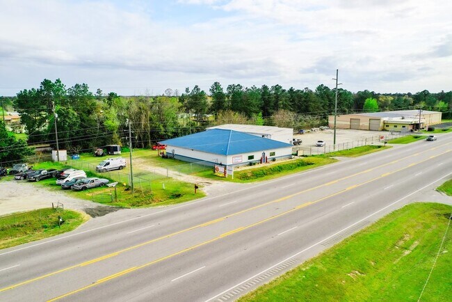
Property Detail
1631 Us Highway 84
024A-035
LL114 LD8
Storebuilding
Pierce
C
Georgia
B and X Area of moderate flood hazard, usually the area between the limits of the 100-year and 500-year floods.
0.52 AC
2025
Georgia South Area
2025
Other Market Areas
960401
Waycross, GA
5,212 SF
NEARBY LISTINGS FOR SALE OR LEASE
DEMOGRAPHICS near 1631 Us Highway 84
1 mile
3 mile
5 mile
2025 Total Population
780
10,264
30,722
2030 Population
808
10,323
31,318
Pop Growth 2025-2030
+ 3.59%
+ 0.57%
+ 1.94%
Average Age
39
41
40
2025 Total Households
281
4,030
12,184
HH Growth 2025-2030
+ 3.56%
+ 0.50%
+ 1.89%
Median Household Inc
$57,618
$56,187
$44,098
Avg Household Size
2.70
2.50
2.40
2025 Avg HH Vehicles
2.00
2.00
2.00
Median Home Value
$134,066
$166,489
$133,029
Median Year Built
1994
1981
1978
Nearby Places
Map Layers
Map Styles
 Street
 Aerial
Layers
 Traffic
 Biking
Places
Listings with unknown addresses are not visible on the map
- Restaurants
- Banks
- Shops
- Fitness
- Groceries
SALE & LEASE HISTORY
LISTING DATE
SALE/LEASE

Mar 12, 2020
For Sale
Nearby Properties
Address
Land Use
TOTAL SIZE
Lot Size
Zoning
Address
Land Use
TOTAL SIZE
Lot Size
Zoning
260,001 SF
14.28 AC
009
Address
Land Use
TOTAL SIZE
Lot Size
Zoning
36,460 SF
10.56 AC
SF
Address
Land Use
TOTAL SIZE
Lot Size
Zoning
51,640 SF
17.20 AC
I
Address
Land Use
TOTAL SIZE
Lot Size
Zoning
9,578 SF
12.17 AC
001
Address
Land Use
TOTAL SIZE
Lot Size
Zoning
8,464 SF
7.98 AC
005
Address
Land Use
TOTAL SIZE
Lot Size
Zoning
8,932 SF
7.59 AC
005
Address
Land Use
TOTAL SIZE
Lot Size
Zoning
6,796 SF
84.19 AC
I
Address
Land Use
TOTAL SIZE
Lot Size
Zoning
39,932 SF
9.83 AC
002
Address
Land Use
TOTAL SIZE
Lot Size
Zoning
3,536 SF
9.03 AC
001
Address
Land Use
TOTAL SIZE
Lot Size
Zoning
13,151 SF
2.58 AC
005
Address
Land Use
TOTAL SIZE
Lot Size
Zoning
107,550 SF
16.48 AC
LI
Address
Land Use
TOTAL SIZE
Lot Size
Zoning
1,288 SF
8.92 AC
I
Address
Land Use
TOTAL SIZE
Lot Size
Zoning
2,600 SF
1.60 AC
LI
Address
Land Use
TOTAL SIZE
Lot Size
Zoning
1,306 SF
2.85 AC
002
Address
Land Use
TOTAL SIZE
Lot Size
Zoning
51,640 SF
17.20 AC
I
Address
Land Use
TOTAL SIZE
Lot Size
Zoning
11,192 SF
202.24 AC
SF
Address
Land Use
TOTAL SIZE
Lot Size
Zoning
17,432 SF
4.03 AC
006
Address
Land Use
TOTAL SIZE
Lot Size
Zoning
33,000 SF
0.95 AC
LI
Address
Land Use
TOTAL SIZE
Lot Size
Zoning
4,488 SF
4.02 AC
002
Address
Land Use
TOTAL SIZE
Lot Size
Zoning
7,974 SF
1.99 AC
006
Address
Land Use
TOTAL SIZE
Lot Size
Zoning
21,320 SF
7.42 AC
009
Address
Land Use
TOTAL SIZE
Lot Size
Zoning
6,860 SF
3.34 AC
006
Address
Land Use
TOTAL SIZE
Lot Size
Zoning
17,500 SF
3.42 AC
C
Address
Land Use
TOTAL SIZE
Lot Size
Zoning
2,600 SF
1.60 AC
LI
Address
Land Use
TOTAL SIZE
Lot Size
Zoning
3,920 SF
3.81 AC
C
Address
Land Use
TOTAL SIZE
Lot Size
Zoning
7,372 SF
1.05 AC
009
Address
Land Use
TOTAL SIZE
Lot Size
Zoning
10,062 SF
2.38 AC
002
Address
Land Use
TOTAL SIZE
Lot Size
Zoning
47.83 AC
005
Address
Land Use
TOTAL SIZE
Lot Size
Zoning
30,000 SF
0.69 AC
I
Address
Land Use
TOTAL SIZE
Lot Size
Zoning
21,344 SF
1.60 AC
002
The World's #1 Commercial Real Estate Marketplace
Connect with us
© 2026 CoStar Group
The information above has been obtained from sources believed reliable. While we do not doubt its accuracy we have not verified it and make no guarantee, warranty or representation about it. It is your responsibility to independently confirm its accuracy and completeness. Any projections, opinions, assumptions, or estimates used are for example only and do not represent the current or future performance of the property. The value of this transaction to you depends on tax and other factors which should be evaluated by your tax, financial, and legal advisors. You and your advisors should conduct a careful, independent investigation of the property to determine to your satisfaction the suitability of the property for your needs.