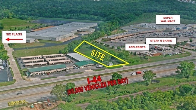
Property Record
1631 W 5Th St, Eureka, MO 63025

Property Detail
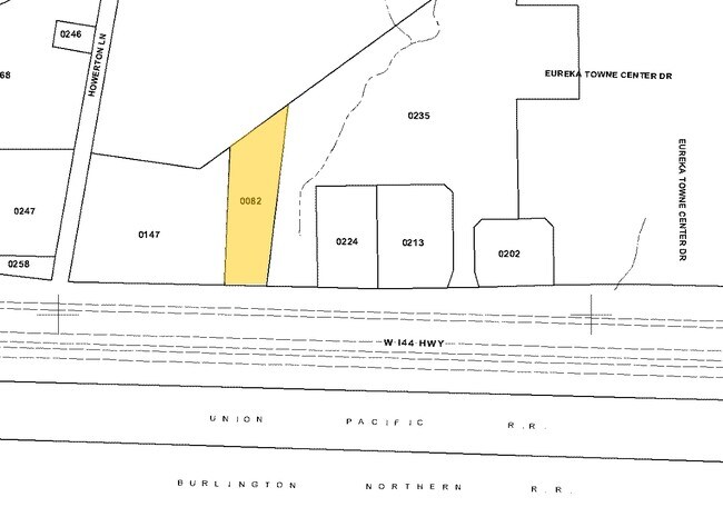
1631 W 5Th St
29W-52-0082
SURVEY 2010 TWN 44 R 3
Officebuilding
Saint Louis
98PC
Missouri
B and X Area of moderate flood hazard, usually the area between the limits of the 100-year and 500-year floods.
1.08 AC
2024
West County
2025
St. Louis
221502
St. Louis, MO-IL
4,080 SF
NEARBY LISTINGS FOR SALE OR LEASE
DEMOGRAPHICS near 1631 W 5Th St
1 mile
3 mile
5 mile
2024 Total Population
5,042
16,566
26,708
2029 Population
5,087
16,766
27,025
Pop Growth 2024-2029
+ 0.89%
+ 1.21%
+ 1.19%
Average Age
39
40
41
2024 Total Households
1,603
5,439
9,220
HH Growth 2024-2029
+ 1.00%
+ 1.14%
+ 1.15%
Median Household Inc
$120,411
$132,284
$130,348
Avg Household Size
2.80
2.80
2.70
2024 Avg HH Vehicles
2.00
2.00
2.00
Median Home Value
$382,116
$401,991
$412,368
Median Year Built
1998
1997
1995
Nearby Places
Map Layers
Map Styles
 Street
 Aerial
Transit
 Traffic
 Biking
Places
Listings with unknown addresses are not visible on the map
- Restaurants
- Banks
- Shops
- Fitness
- Groceries
PUBLIC TRANSPORTATION
AIRPORT
St Louis Lambert International
Drive
Walk
Distance
St Louis Lambert International
46 min
32.3 mi
Freight Ports
Tulsa Port of Inola
Drive
Walk
Distance
Tulsa Port of Inola
389 min
355.7 mi
Nearby Properties
Address
Land Use
TOTAL SIZE
Lot Size
Zoning
Address
Land Use
TOTAL SIZE
Lot Size
Zoning
3,373 SF
1,418.57 AC
PS
Address
Land Use
TOTAL SIZE
Lot Size
Zoning
258,378 SF
170.04 AC
44C-1
Address
Land Use
TOTAL SIZE
Lot Size
Zoning
12,274 SF
86.91 AC
R1
Address
Land Use
TOTAL SIZE
Lot Size
Zoning
1,387.09 AC
PS
Address
Land Use
TOTAL SIZE
Lot Size
Zoning
207,499 SF
10.11 AC
98R-5
Address
Land Use
TOTAL SIZE
Lot Size
Zoning
13.13 AC
Address
Land Use
TOTAL SIZE
Lot Size
Zoning
39.97 AC
98PI
Address
Land Use
TOTAL SIZE
Lot Size
Zoning
64,048 SF
15.16 AC
NU
Address
Land Use
TOTAL SIZE
Lot Size
Zoning
351,908 SF
308.90 AC
NU
Address
Land Use
TOTAL SIZE
Lot Size
Zoning
153,647 SF
22.80 AC
98C
Address
Land Use
TOTAL SIZE
Lot Size
Zoning
250,959 SF
22.13 AC
98M-1
Address
Land Use
TOTAL SIZE
Lot Size
Zoning
85,759 SF
8.25 AC
H
Address
Land Use
TOTAL SIZE
Lot Size
Zoning
203,960 SF
12.88 AC
NU
Address
Land Use
TOTAL SIZE
Lot Size
Zoning
7.50 AC
98R-1
Address
Land Use
TOTAL SIZE
Lot Size
Zoning
8.30 AC
Address
Land Use
TOTAL SIZE
Lot Size
Zoning
29,960 SF
14.54 AC
NU
Address
Land Use
TOTAL SIZE
Lot Size
Zoning
131,963 SF
61.74 AC
NU
Address
Land Use
TOTAL SIZE
Lot Size
Zoning
899 SF
1.41 AC
R3
Address
Land Use
TOTAL SIZE
Lot Size
Zoning
27,588 SF
11.07 AC
H
Address
Land Use
TOTAL SIZE
Lot Size
Zoning
5,088 SF
146.21 AC
PS
Address
Land Use
TOTAL SIZE
Lot Size
Zoning
7.26 AC
R3
Address
Land Use
TOTAL SIZE
Lot Size
Zoning
7.48 AC
R4
Address
Land Use
TOTAL SIZE
Lot Size
Zoning
46,777 SF
71 AC
107NU
Address
Land Use
TOTAL SIZE
Lot Size
Zoning
46,615 SF
6.91 AC
98C
Address
Land Use
TOTAL SIZE
Lot Size
Zoning
1,530 SF
0.89 AC
Address
Land Use
TOTAL SIZE
Lot Size
Zoning
60,655 SF
2.95 AC
R-5
Address
Land Use
TOTAL SIZE
Lot Size
Zoning
99.75 AC
R1
Address
Land Use
TOTAL SIZE
Lot Size
Zoning
26,024 SF
2.65 AC
98PC
Address
Land Use
TOTAL SIZE
Lot Size
Zoning
69,225 SF
2.45 AC
98C
Address
Land Use
TOTAL SIZE
Lot Size
Zoning
9.10 AC
98R-1
The World's #1 Commercial Real Estate Marketplace
Connect with us
© 2026 CoStar Group
The information above has been obtained from sources believed reliable. While we do not doubt its accuracy we have not verified it and make no guarantee, warranty or representation about it. It is your responsibility to independently confirm its accuracy and completeness. Any projections, opinions, assumptions, or estimates used are for example only and do not represent the current or future performance of the property. The value of this transaction to you depends on tax and other factors which should be evaluated by your tax, financial, and legal advisors. You and your advisors should conduct a careful, independent investigation of the property to determine to your satisfaction the suitability of the property for your needs.