Property Record
1632 E Joppa Rd, Towson, MD 21286
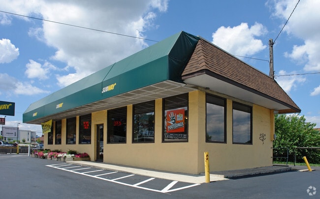

Property Detail
1632 E Joppa Rd
09-0918474760
LT NS JOPPA RD
Restaurantdrivein
Baltimore
BRCNS
Maryland
B and X Area of moderate flood hazard, usually the area between the limits of the 100-year and 500-year floods.
0.21 AC
2024
Towson
2025
Baltimore
491201
Baltimore-Columbia-Towson, MD
1,791 SF
NEARBY LISTINGS FOR SALE OR LEASE
DEMOGRAPHICS near 1632 E Joppa Rd
1 mile
3 mile
5 mile
2025 Total Population
15,816
129,589
298,845
2030 Population
15,923
128,771
295,275
Pop Growth 2025-2030
+ 0.68%
(0.63%)
(1.19%)
Average Age
39
40
41
2025 Total Households
6,418
53,110
118,311
HH Growth 2025-2030
+ 0.69%
(0.64%)
(1.24%)
Median Household Inc
$78,938
$81,338
$86,021
Avg Household Size
2.40
2.30
2.40
2025 Avg HH Vehicles
2.00
2.00
2.00
Median Home Value
$260,678
$296,885
$305,782
Median Year Built
1956
1958
1958
Nearby Places
Map Layers
Map Styles
 Street
 Aerial
Transit
 Traffic
 Biking
Places
Listings with unknown addresses are not visible on the map
- Restaurants
- Banks
- Shops
- Fitness
- Groceries
PUBLIC TRANSPORTATION
COMMUTER RAIL
Penn Station (Penn Line - Maryland Area Regional Commuter Trains (The MARC))
Drive
Walk
Distance
Penn Station (Penn Line - Maryland Area Regional Commuter Trains (The MARC))
18 min
7.5 mi
Drive
Walk
Distance
24 min
9.4 mi
AIRPORT
Baltimore/Washington International Thurgood Marshall
Drive
Walk
Distance
Baltimore/Washington International Thurgood Marshall
38 min
24.6 mi
Freight Ports
Port of Baltimore
Drive
Walk
Distance
Port of Baltimore
23 min
9.0 mi
SALE & LEASE HISTORY
LISTING DATE
SALE/LEASE

Jul 12, 2021
For Sale
Aug 29, 2022
For Lease
Nearby Properties
Address
Land Use
TOTAL SIZE
Lot Size
Zoning
Address
Land Use
TOTAL SIZE
Lot Size
Zoning
363,750 SF
87 SF
Address
Land Use
TOTAL SIZE
Lot Size
Zoning
940,291 SF
23.80 AC
BMCT
Address
Land Use
TOTAL SIZE
Lot Size
Zoning
1,704,075 SF
76.16 AC
Address
Land Use
TOTAL SIZE
Lot Size
Zoning
316,273 SF
25.90 AC
H
Address
Land Use
TOTAL SIZE
Lot Size
Zoning
712,387 SF
2.20 AC
BM-CT
Address
Land Use
TOTAL SIZE
Lot Size
Zoning
723,067 SF
80.37 AC
OR2
Address
Land Use
TOTAL SIZE
Lot Size
Zoning
731,797 SF
5.32 AC
RAE2
Address
Land Use
TOTAL SIZE
Lot Size
Zoning
296,575 SF
0.01 AC
DR16
Address
Land Use
TOTAL SIZE
Lot Size
Zoning
31.22 AC
DR16
Address
Land Use
TOTAL SIZE
Lot Size
Zoning
725,588 SF
43.12 AC
BLCCC
Address
Land Use
TOTAL SIZE
Lot Size
Zoning
189,300 SF
1.83 AC
BM
Address
Land Use
TOTAL SIZE
Lot Size
Zoning
643,976 SF
4.54 AC
RAE2
Address
Land Use
TOTAL SIZE
Lot Size
Zoning
303,115 SF
7.62 AC
R-3
Address
Land Use
TOTAL SIZE
Lot Size
Zoning
30.89 AC
DR16
Address
Land Use
TOTAL SIZE
Lot Size
Zoning
0.01 AC
DR5,5
Address
Land Use
TOTAL SIZE
Lot Size
Zoning
318,948 SF
7.35 AC
BM
Address
Land Use
TOTAL SIZE
Lot Size
Zoning
585,866 SF
1.24 AC
BM-CT
Address
Land Use
TOTAL SIZE
Lot Size
Zoning
184,968 SF
4.25 AC
Address
Land Use
TOTAL SIZE
Lot Size
Zoning
204,974 SF
5.87 AC
DR16
Address
Land Use
TOTAL SIZE
Lot Size
Zoning
578,808 SF
30.10 AC
Address
Land Use
TOTAL SIZE
Lot Size
Zoning
523,464 SF
3.43 AC
RAE2
Address
Land Use
TOTAL SIZE
Lot Size
Zoning
2.70 AC
BM-CT
Address
Land Use
TOTAL SIZE
Lot Size
Zoning
15.49 AC
DR16
Address
Land Use
TOTAL SIZE
Lot Size
Zoning
2.88 AC
Address
Land Use
TOTAL SIZE
Lot Size
Zoning
7,718 SF
152.79 AC
OS
Address
Land Use
TOTAL SIZE
Lot Size
Zoning
67,938 SF
31.72 AC
BL
Address
Land Use
TOTAL SIZE
Lot Size
Zoning
11.56 AC
DR16
Address
Land Use
TOTAL SIZE
Lot Size
Zoning
15.82 AC
BLCCC
Address
Land Use
TOTAL SIZE
Lot Size
Zoning
41,184 SF
93.14 AC
EC-1
Address
Land Use
TOTAL SIZE
Lot Size
Zoning
10.63 AC
DR16
The World's #1 Commercial Real Estate Marketplace
Connect with us
© 2026 CoStar Group
The information above has been obtained from sources believed reliable. While we do not doubt its accuracy we have not verified it and make no guarantee, warranty or representation about it. It is your responsibility to independently confirm its accuracy and completeness. Any projections, opinions, assumptions, or estimates used are for example only and do not represent the current or future performance of the property. The value of this transaction to you depends on tax and other factors which should be evaluated by your tax, financial, and legal advisors. You and your advisors should conduct a careful, independent investigation of the property to determine to your satisfaction the suitability of the property for your needs.