Property Record
1632 Riverdale St, West Springfield, MA 01089
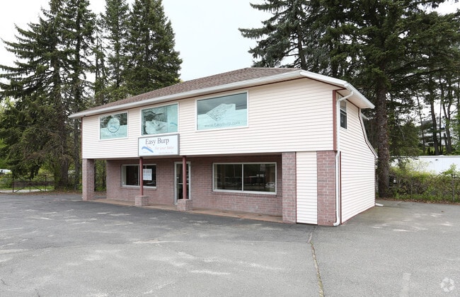


This Property Is For Sale
NEARBY LISTINGS FOR SALE OR LEASE
Property Detail
1632 Riverdale St
WSPR-000226-010950-R000001
Hampden
Departmentstore
Massachusetts
AE
r1
25013C0194E
0.26 AC
2025
Hampden County
2025
Hartford
812202
Springfield, MA
1,960 SF
DEMOGRAPHICS near 1632 Riverdale St
1 Mile
3 Mile
5 Mile
2024 Total Population
3,896
72,175
199,187
2029 Population
3,839
70,708
195,352
Pop Growth 2024-2029
(1.46%)
(2.03%)
(1.93%)
Average Age
44
40
39
2024 Total Households
1,934
29,724
80,431
HH Growth 2024-2029
(1.45%)
(2.09%)
(1.97%)
Median Household Inc
$50,425
$53,049
$47,380
Avg Household Size
2.00
2.30
2.30
2024 Avg HH Vehicles
1.00
1.00
1.00
Median Home Value
$233,509
$238,821
$233,614
Median Year Built
1967
1953
1952
Nearby Places
Map Layers
Map Styles
 Street
 Aerial
- Restaurants
- Banks
- Shops
- Fitness
- Groceries
PUBLIC TRANSPORTATION
COMMUTER RAIL
Springfield (Amtrak Hartford Line - Amtrak, Hartford Line - Amtrak, Lake Shore Limited - Amtrak, Northeast Regional - Amtrak, Valley Flyer - Amtrak, Vermonter - Amtrak)
DRIVE
WALK
Distance
Springfield (Amtrak Hartford Line - Amtrak, Hartford Line - Amtrak, Lake Shore Limited - Amtrak, Northeast Regional - Amtrak, Valley Flyer - Amtrak, Vermonter - Amtrak)
8 min
4.8 mi
Holyoke Amtrak (Valley Flyer - Amtrak, Vermonter - Amtrak)
DRIVE
WALK
Distance
Holyoke Amtrak (Valley Flyer - Amtrak, Vermonter - Amtrak)
9 min
5.1 mi
AIRPORT
Bradley International
DRIVE
WALK
Distance
Bradley International
36 min
16.0 mi
Freight Ports
Port of New Haven
DRIVE
WALK
Distance
Port of New Haven
89 min
69.1 mi
Nearby Properties
Address
Land Use
TOTAL SIZE
Lot Size
Zoning
Address
Land Use
TOTAL SIZE
Lot Size
Zoning
50.97 AC
BH
Address
Land Use
TOTAL SIZE
Lot Size
Zoning
247,375 SF
19.52 AC
B2
Address
Land Use
TOTAL SIZE
Lot Size
Zoning
257,525 SF
64.03 AC
Address
Land Use
TOTAL SIZE
Lot Size
Zoning
21.80 AC
106
Address
Land Use
TOTAL SIZE
Lot Size
Zoning
112,378 SF
3.03 AC
R2
Address
Land Use
TOTAL SIZE
Lot Size
Zoning
286,624 SF
17.40 AC
102
Address
Land Use
TOTAL SIZE
Lot Size
Zoning
261,176 SF
33.36 AC
Address
Land Use
TOTAL SIZE
Lot Size
Zoning
24.55 AC
102
Address
Land Use
TOTAL SIZE
Lot Size
Zoning
200,000 SF
13.91 AC
R3
Address
Land Use
TOTAL SIZE
Lot Size
Zoning
29.88 AC
105
Address
Land Use
TOTAL SIZE
Lot Size
Zoning
189,022 SF
10.62 AC
RA
Address
Land Use
TOTAL SIZE
Lot Size
Zoning
201,800 SF
6.27 AC
R5
Address
Land Use
TOTAL SIZE
Lot Size
Zoning
186,700 SF
11.17 AC
SR3R5
Address
Land Use
TOTAL SIZE
Lot Size
Zoning
102,787 SF
7.38 AC
I2
Address
Land Use
TOTAL SIZE
Lot Size
Zoning
138,504 SF
13.18 AC
RO
Address
Land Use
TOTAL SIZE
Lot Size
Zoning
128,877 SF
28.75 AC
Address
Land Use
TOTAL SIZE
Lot Size
Zoning
30.45 AC
106
Address
Land Use
TOTAL SIZE
Lot Size
Zoning
181,008 SF
10 AC
102
Address
Land Use
TOTAL SIZE
Lot Size
Zoning
9.80 AC
101
Address
Land Use
TOTAL SIZE
Lot Size
Zoning
229,164 SF
3.80 AC
R5
Address
Land Use
TOTAL SIZE
Lot Size
Zoning
1.50 AC
105
Address
Land Use
TOTAL SIZE
Lot Size
Zoning
141,475 SF
31.69 AC
S
Address
Land Use
TOTAL SIZE
Lot Size
Zoning
106,660 SF
3.37 AC
I2
Address
Land Use
TOTAL SIZE
Lot Size
Zoning
73,904 SF
4.51 AC
I2
Address
Land Use
TOTAL SIZE
Lot Size
Zoning
12.90 AC
IP
Address
Land Use
TOTAL SIZE
Lot Size
Zoning
17.64 AC
105
Address
Land Use
TOTAL SIZE
Lot Size
Zoning
73,512 SF
5.54 AC
Address
Land Use
TOTAL SIZE
Lot Size
Zoning
136,654 SF
11.71 AC
BG
Address
Land Use
TOTAL SIZE
Lot Size
Zoning
65,942 SF
2.62 AC
R2
Address
Land Use
TOTAL SIZE
Lot Size
Zoning
63,684 SF
4.33 AC
B2
The World's #1 Commercial Real Estate Marketplace
Connect with us
© 2025 CoStar Group
The information above has been obtained from sources believed reliable. While we do not doubt its accuracy we have not verified it and make no guarantee, warranty or representation about it. It is your responsibility to independently confirm its accuracy and completeness. Any projections, opinions, assumptions, or estimates used are for example only and do not represent the current or future performance of the property. The value of this transaction to you depends on tax and other factors which should be evaluated by your tax, financial, and legal advisors. You and your advisors should conduct a careful, independent investigation of the property to determine to your satisfaction the suitability of the property for your needs.