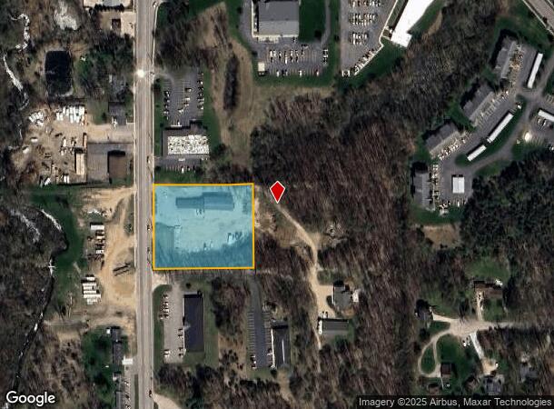
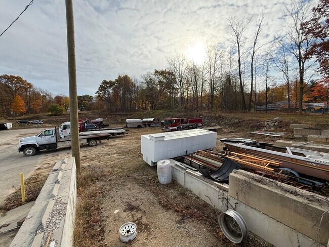
Property Record
1633 S Hanover St, Hastings, MI 49058
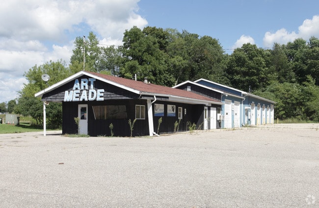
This Property Is For Sale
NEARBY LISTINGS FOR SALE OR LEASE
Property Detail
1633 S Hanover St
Grand Rapids-Wyoming, MI
Supervisor Glasgows Add
55-250-018-00
CITY OF HASTINGS N 1/2 LOT 15, SUPERVISOR GLASGOW'S ADD. SPLIT ON 02/07/2024 WITH 55-250-019-00 INTO 55-250-018-10, 55-250-019-10;
Autorepair
Barry
X
Michigan
26015C0193C
15
2024
2.25 AC
2025
Barry County
011301
West Michigan
5,068 SF
DEMOGRAPHICS near 1633 S Hanover St
1 Mile
3 Mile
5 Mile
2024 Total Population
3,755
9,824
14,829
2029 Population
3,912
10,215
15,446
Pop Growth 2024-2029
+ 4.18%
+ 3.98%
+ 4.16%
Average Age
38
41
42
2024 Total Households
1,466
3,969
5,974
HH Growth 2024-2029
+ 4.23%
+ 3.98%
+ 4.15%
Median Household Inc
$62,520
$58,280
$61,631
Avg Household Size
2.50
2.40
2.40
2024 Avg HH Vehicles
2.00
2.00
2.00
Median Home Value
$139,252
$159,902
$173,214
Median Year Built
1962
1966
1968
Nearby Places
- Restaurants
- Banks
- Shops
- Fitness
- Groceries
PUBLIC TRANSPORTATION
AIRPORT
Gerald R Ford International
DRIVE
WALK
Distance
Gerald R Ford International
43 min
25.6 mi
Freight Ports
Port of Toledo
DRIVE
WALK
Distance
Port of Toledo
191 min
146.7 mi
Nearby Properties
Address
Land Use
TOTAL SIZE
Lot Size
Zoning
Address
Land Use
TOTAL SIZE
Lot Size
Zoning
156,011 SF
6.76 AC
A-O
Address
Land Use
TOTAL SIZE
Lot Size
Zoning
100,000 SF
Address
Land Use
TOTAL SIZE
Lot Size
Zoning
231,772 SF
13.51 AC
D-2
Address
Land Use
TOTAL SIZE
Lot Size
Zoning
92,343 SF
1.21 AC
PUD
Address
Land Use
TOTAL SIZE
Lot Size
Zoning
105,705 SF
18.80 AC
Address
Land Use
TOTAL SIZE
Lot Size
Zoning
4,646 SF
1.04 AC
B-2
Address
Land Use
TOTAL SIZE
Lot Size
Zoning
24,938 SF
2.01 AC
B-1
Address
Land Use
TOTAL SIZE
Lot Size
Zoning
58,800 SF
4 AC
PUD
Address
Land Use
TOTAL SIZE
Lot Size
Zoning
39,800 SF
3.10 AC
MU
Address
Land Use
TOTAL SIZE
Lot Size
Zoning
79,428 SF
8.97 AC
B-2
Address
Land Use
TOTAL SIZE
Lot Size
Zoning
81,000 SF
Address
Land Use
TOTAL SIZE
Lot Size
Zoning
95,899 SF
23.29 AC
MU
Address
Land Use
TOTAL SIZE
Lot Size
Zoning
202,882 SF
12.63 AC
D-2
Address
Land Use
TOTAL SIZE
Lot Size
Zoning
42,369 SF
11.77 AC
A-O
Address
Land Use
TOTAL SIZE
Lot Size
Zoning
47,735 SF
38.74 AC
Address
Land Use
TOTAL SIZE
Lot Size
Zoning
29,759 SF
2.69 AC
A-1
Address
Land Use
TOTAL SIZE
Lot Size
Zoning
25.23 AC
PUD
Address
Land Use
TOTAL SIZE
Lot Size
Zoning
1,300 SF
31.80 AC
MU
Address
Land Use
TOTAL SIZE
Lot Size
Zoning
81,110 SF
14.12 AC
LI
Address
Land Use
TOTAL SIZE
Lot Size
Zoning
18,804 SF
3.67 AC
B-2
Address
Land Use
TOTAL SIZE
Lot Size
Zoning
91,080 SF
Address
Land Use
TOTAL SIZE
Lot Size
Zoning
Address
Land Use
TOTAL SIZE
Lot Size
Zoning
28,021 SF
3.54 AC
PUD
Address
Land Use
TOTAL SIZE
Lot Size
Zoning
81,563 SF
7.66 AC
Address
Land Use
TOTAL SIZE
Lot Size
Zoning
40,624 SF
3.31 AC
A-O
Address
Land Use
TOTAL SIZE
Lot Size
Zoning
28,392 SF
1.90 AC
PUD
Address
Land Use
TOTAL SIZE
Lot Size
Zoning
58,694 SF
9.29 AC
LI
Address
Land Use
TOTAL SIZE
Lot Size
Zoning
31,578 SF
5.27 AC
Address
Land Use
TOTAL SIZE
Lot Size
Zoning
13,378 SF
5.89 AC
PUD
Address
Land Use
TOTAL SIZE
Lot Size
Zoning
14,144 SF
1.06 AC
B-4
The World's #1 Commercial Real Estate Marketplace
Connect with us
© 2025 CoStar Group
The information above has been obtained from sources believed reliable. While we do not doubt its accuracy we have not verified it and make no guarantee, warranty or representation about it. It is your responsibility to independently confirm its accuracy and completeness. Any projections, opinions, assumptions, or estimates used are for example only and do not represent the current or future performance of the property. The value of this transaction to you depends on tax and other factors which should be evaluated by your tax, financial, and legal advisors. You and your advisors should conduct a careful, independent investigation of the property to determine to your satisfaction the suitability of the property for your needs.