Property Record
16348 70Th St Ne, Otsego, MN 55330
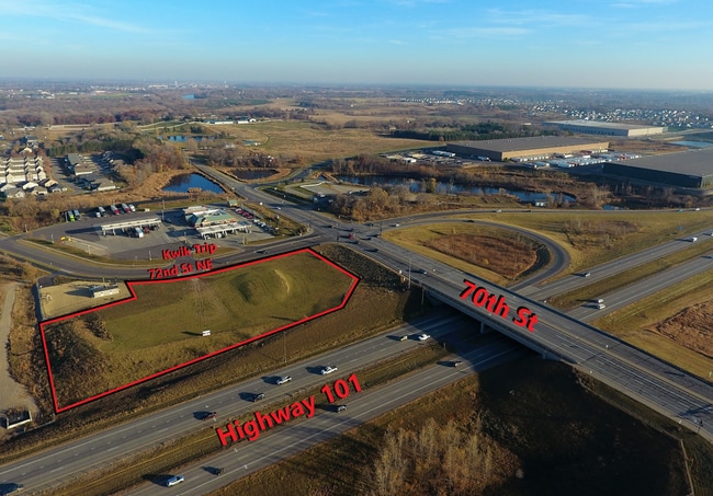
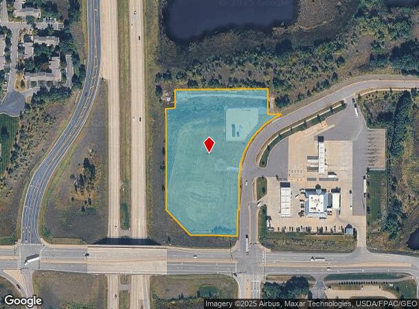
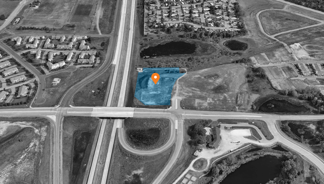

This Property Is For Sale
NEARBY LISTINGS FOR SALE OR LEASE
Property Detail
16348 70Th St Ne
Minneapolis/St Paul
Riverbend South
Minneapolis-St. Paul-Bloomington, MN-WI
SECT-26 TWP-121 RANGE-023 RIVERBEND SOUTH OUTLOT C
118-289-000030
Wright
Realpropertynec
Minnesota
2025
4.32 AC
2025
Wright County
030503
DEMOGRAPHICS near 16348 70Th St Ne
1 Mile
3 Mile
5 Mile
2024 Total Population
3,218
18,565
65,336
2029 Population
3,684
20,730
71,025
Pop Growth 2024-2029
+ 14.48%
+ 11.66%
+ 8.71%
Average Age
37
38
37
2024 Total Households
1,244
6,658
22,779
HH Growth 2024-2029
+ 14.63%
+ 11.76%
+ 8.79%
Median Household Inc
$117,919
$114,805
$107,299
Avg Household Size
2.60
2.70
2.80
2024 Avg HH Vehicles
2.00
2.00
2.00
Median Home Value
$344,709
$350,227
$326,038
Median Year Built
2007
2004
2001
Nearby Places
Map Layers
Map Styles
 Street
 Aerial
- Restaurants
- Banks
- Shops
- Fitness
- Groceries
PUBLIC TRANSPORTATION
COMMUTER RAIL
Elk River Station (Northstar Corridor - Northstar Commuter Rail)
DRIVE
WALK
Distance
Elk River Station (Northstar Corridor - Northstar Commuter Rail)
7 min
4.3 mi
Ramsey Station & Platform (Northstar Commuter Rail - Metro Transit)
DRIVE
WALK
Distance
Ramsey Station & Platform (Northstar Commuter Rail - Metro Transit)
14 min
9.9 mi
Freight Ports
Port Milwaukee
DRIVE
WALK
Distance
Port Milwaukee
406 min
366.4 mi
Nearby Properties
Address
Land Use
TOTAL SIZE
Lot Size
Zoning
Address
Land Use
TOTAL SIZE
Lot Size
Zoning
706,604 SF
30.67 AC
Address
Land Use
TOTAL SIZE
Lot Size
Zoning
401,188 SF
20.74 AC
Address
Land Use
TOTAL SIZE
Lot Size
Zoning
163,282 SF
5.25 AC
Address
Land Use
TOTAL SIZE
Lot Size
Zoning
148,214 SF
8.73 AC
Address
Land Use
TOTAL SIZE
Lot Size
Zoning
299,904 SF
18.63 AC
Address
Land Use
TOTAL SIZE
Lot Size
Zoning
267,924 SF
13.88 AC
Address
Land Use
TOTAL SIZE
Lot Size
Zoning
23.48 AC
Address
Land Use
TOTAL SIZE
Lot Size
Zoning
103,080 SF
5.47 AC
Address
Land Use
TOTAL SIZE
Lot Size
Zoning
212,224 SF
12.84 AC
Address
Land Use
TOTAL SIZE
Lot Size
Zoning
107,952 SF
3.52 AC
Address
Land Use
TOTAL SIZE
Lot Size
Zoning
113 SF
8.08 AC
Address
Land Use
TOTAL SIZE
Lot Size
Zoning
113 SF
5.30 AC
Address
Land Use
TOTAL SIZE
Lot Size
Zoning
14.07 AC
Address
Land Use
TOTAL SIZE
Lot Size
Zoning
Address
Land Use
TOTAL SIZE
Lot Size
Zoning
176,540 SF
14.08 AC
Address
Land Use
TOTAL SIZE
Lot Size
Zoning
90,810 SF
14.19 AC
Address
Land Use
TOTAL SIZE
Lot Size
Zoning
154,800 SF
8.74 AC
Address
Land Use
TOTAL SIZE
Lot Size
Zoning
7,280 SF
40.06 AC
Address
Land Use
TOTAL SIZE
Lot Size
Zoning
85,493 SF
46.22 AC
Address
Land Use
TOTAL SIZE
Lot Size
Zoning
Address
Land Use
TOTAL SIZE
Lot Size
Zoning
1,720 SF
4.56 AC
Address
Land Use
TOTAL SIZE
Lot Size
Zoning
100,134 SF
10.36 AC
Address
Land Use
TOTAL SIZE
Lot Size
Zoning
Address
Land Use
TOTAL SIZE
Lot Size
Zoning
Address
Land Use
TOTAL SIZE
Lot Size
Zoning
2,066 SF
174.85 AC
Address
Land Use
TOTAL SIZE
Lot Size
Zoning
7.36 AC
Address
Land Use
TOTAL SIZE
Lot Size
Zoning
29.54 AC
Address
Land Use
TOTAL SIZE
Lot Size
Zoning
42,492 SF
5.91 AC
Address
Land Use
TOTAL SIZE
Lot Size
Zoning
5.92 AC
Address
Land Use
TOTAL SIZE
Lot Size
Zoning
6,030 SF
9.29 AC
The World's #1 Commercial Real Estate Marketplace
Connect with us
© 2026 CoStar Group
The information above has been obtained from sources believed reliable. While we do not doubt its accuracy we have not verified it and make no guarantee, warranty or representation about it. It is your responsibility to independently confirm its accuracy and completeness. Any projections, opinions, assumptions, or estimates used are for example only and do not represent the current or future performance of the property. The value of this transaction to you depends on tax and other factors which should be evaluated by your tax, financial, and legal advisors. You and your advisors should conduct a careful, independent investigation of the property to determine to your satisfaction the suitability of the property for your needs.