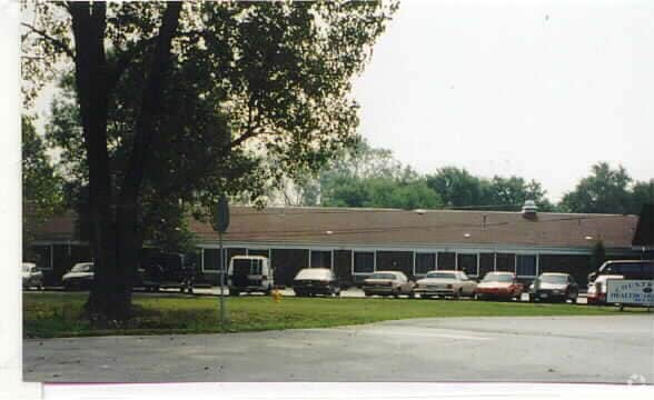
Property Record
1635 E Pulaski Rd, Dolton, IL 60419

Property Detail
1635 E Pulaski Rd
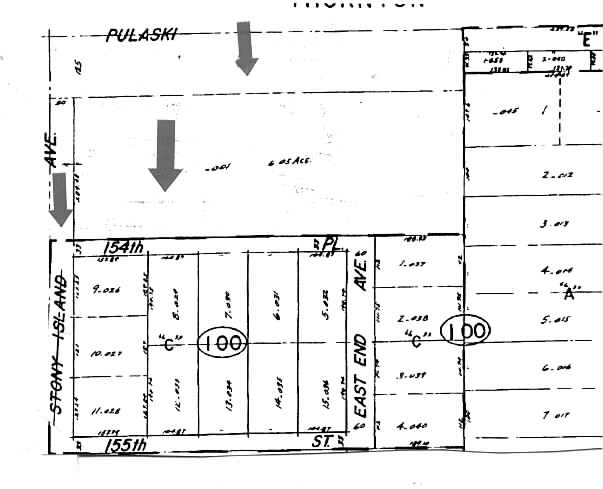
29-13-100-001-0000
COOK
Commercialnec
Illinois
B and X Area of moderate flood hazard, usually the area between the limits of the 100-year and 500-year floods.
6.43 AC
2023
Near South Cook
2025
Chicago
826402
Chicago-Naperville-Elgin, IL-IN
40,489 SF
NEARBY LISTINGS FOR SALE OR LEASE
-
-
View all Dolton listings for sale on LoopNet.com
DEMOGRAPHICS near 1635 E Pulaski Rd
1 mile
3 mile
5 mile
2025 Total Population
16,268
101,377
248,633
2030 Population
16,307
102,852
252,124
Pop Growth 2025-2030
+ 0.24%
+ 1.45%
+ 1.40%
Average Age
42
41
40
2025 Total Households
6,535
37,917
92,071
HH Growth 2025-2030
(0.32%)
+ 1.18%
+ 1.21%
Median Household Inc
$62,174
$60,125
$55,621
Avg Household Size
2.40
2.60
2.60
2025 Avg HH Vehicles
1.00
2.00
2.00
Median Home Value
$156,618
$157,605
$155,838
Median Year Built
1970
1965
1959
Nearby Places
Map Layers
Map Styles
 Street
 Aerial
Transit
 Traffic
 Biking
Places
Listings with unknown addresses are not visible on the map
- Restaurants
- Banks
- Shops
- Fitness
- Groceries
PUBLIC TRANSPORTATION
COMMUTER RAIL
Drive
Walk
Distance
7 min
3.4 mi
Ivanhoe Station (Metra Electric Line - Northeast Illinois Regional Commuter Railroad (Metra))
Drive
Walk
Distance
Ivanhoe Station (Metra Electric Line - Northeast Illinois Regional Commuter Railroad (Metra))
9 min
3.6 mi
AIRPORT
Chicago Midway International
Drive
Walk
Distance
Chicago Midway International
34 min
18.9 mi
Chicago O'Hare International
Drive
Walk
Distance
Chicago O'Hare International
76 min
40.8 mi
Nearby Properties
Address
Land Use
TOTAL SIZE
Lot Size
Zoning
Address
Land Use
TOTAL SIZE
Lot Size
Zoning
399,000 SF
23.92 AC
Address
Land Use
TOTAL SIZE
Lot Size
Zoning
82,736 SF
0.37 AC
Address
Land Use
TOTAL SIZE
Lot Size
Zoning
144,256 SF
2.91 AC
R3
Address
Land Use
TOTAL SIZE
Lot Size
Zoning
24.56 AC
Address
Land Use
TOTAL SIZE
Lot Size
Zoning
Address
Land Use
TOTAL SIZE
Lot Size
Zoning
115,612 SF
4.20 AC
Address
Land Use
TOTAL SIZE
Lot Size
Zoning
29.25 AC
PMD 6
Address
Land Use
TOTAL SIZE
Lot Size
Zoning
5.01 AC
Address
Land Use
TOTAL SIZE
Lot Size
Zoning
755,859 SF
8.77 AC
Address
Land Use
TOTAL SIZE
Lot Size
Zoning
106,812 SF
8.78 AC
Address
Land Use
TOTAL SIZE
Lot Size
Zoning
119,082 SF
11.26 AC
Address
Land Use
TOTAL SIZE
Lot Size
Zoning
48,134 SF
5.33 AC
Address
Land Use
TOTAL SIZE
Lot Size
Zoning
62,256 SF
4.95 AC
R3
Address
Land Use
TOTAL SIZE
Lot Size
Zoning
14,418 SF
2.25 AC
R3
Address
Land Use
TOTAL SIZE
Lot Size
Zoning
51,204 SF
0.34 AC
Address
Land Use
TOTAL SIZE
Lot Size
Zoning
69,894 SF
7.60 AC
Address
Land Use
TOTAL SIZE
Lot Size
Zoning
450,777 SF
25.25 AC
Address
Land Use
TOTAL SIZE
Lot Size
Zoning
454,999 SF
27.43 AC
Address
Land Use
TOTAL SIZE
Lot Size
Zoning
60,864 SF
5.55 AC
Address
Land Use
TOTAL SIZE
Lot Size
Zoning
7.31 AC
Address
Land Use
TOTAL SIZE
Lot Size
Zoning
Address
Land Use
TOTAL SIZE
Lot Size
Zoning
25,058 SF
0.19 AC
Address
Land Use
TOTAL SIZE
Lot Size
Zoning
68,788 SF
16.61 AC
Address
Land Use
TOTAL SIZE
Lot Size
Zoning
44,189 SF
3.09 AC
Address
Land Use
TOTAL SIZE
Lot Size
Zoning
Address
Land Use
TOTAL SIZE
Lot Size
Zoning
58,730 SF
3.97 AC
Address
Land Use
TOTAL SIZE
Lot Size
Zoning
27,606 SF
2.87 AC
Address
Land Use
TOTAL SIZE
Lot Size
Zoning
362,552 SF
44.53 AC
PD 1350
Address
Land Use
TOTAL SIZE
Lot Size
Zoning
10,010 SF
1.37 AC
R33
The World's #1 Commercial Real Estate Marketplace
Connect with us
© 2026 CoStar Group
The information above has been obtained from sources believed reliable. While we do not doubt its accuracy we have not verified it and make no guarantee, warranty or representation about it. It is your responsibility to independently confirm its accuracy and completeness. Any projections, opinions, assumptions, or estimates used are for example only and do not represent the current or future performance of the property. The value of this transaction to you depends on tax and other factors which should be evaluated by your tax, financial, and legal advisors. You and your advisors should conduct a careful, independent investigation of the property to determine to your satisfaction the suitability of the property for your needs.