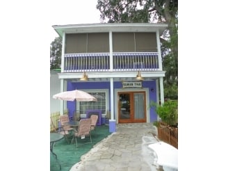
Property Record
1635 Paris Ave, Port Royal, SC 29935

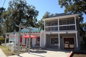
NEARBY LISTINGS FOR SALE OR LEASE
Property Detail
1635 Paris Ave
Hilton Head Island-Bluffton-Port Royal, SC
Port Royal Vil Comm & Mixed Us
R110-010-000-0334-0000
PAR A PB121 P186 LOT LINE REV 4/2010 ACREAGE CHGD PB127 P128
Storebuilding
Beaufort
2025
South Carolina
2024
0.10 AC
000800
Other Market Areas
1,081 SF
DEMOGRAPHICS near 1635 Paris Ave
1 Mile
3 Mile
5 Mile
2024 Total Population
4,657
18,176
38,793
2029 Population
5,136
19,907
42,738
Pop Growth 2024-2029
+ 10.29%
+ 9.52%
+ 10.17%
Average Age
39
37
38
2024 Total Households
2,079
6,296
14,216
HH Growth 2024-2029
+ 9.91%
+ 10.13%
+ 10.42%
Median Household Inc
$58,586
$70,446
$58,982
Avg Household Size
2.10
2.30
2.40
2024 Avg HH Vehicles
2.00
2.00
2.00
Median Home Value
$236,111
$290,518
$288,385
Median Year Built
1982
1989
1990
Nearby Places
Map Layers
Map Styles
 Street
 Aerial
- Restaurants
- Banks
- Shops
- Fitness
- Groceries
PUBLIC TRANSPORTATION
AIRPORT
Hilton Head
DRIVE
WALK
Distance
Hilton Head
50 min
36.6 mi
Freight Ports
Georgia Ports - Savannah
DRIVE
WALK
Distance
Georgia Ports - Savannah
60 min
46.0 mi
SALE & LEASE HISTORY
LISTING DATE
SALE/LEASE

Jun 08, 2017
For Sale
Aug 02, 2017
For Sale
Nearby Properties
Address
Land Use
TOTAL SIZE
Lot Size
Zoning
Address
Land Use
TOTAL SIZE
Lot Size
Zoning
8,358 SF
21.89 AC
6611
Address
Land Use
TOTAL SIZE
Lot Size
Zoning
245,864 SF
19.36 AC
6601
Address
Land Use
TOTAL SIZE
Lot Size
Zoning
243,644 SF
13.23 AC
6601
Address
Land Use
TOTAL SIZE
Lot Size
Zoning
78,168 SF
11 AC
Address
Land Use
TOTAL SIZE
Lot Size
Zoning
116,067 SF
27 AC
6611
Address
Land Use
TOTAL SIZE
Lot Size
Zoning
4,928 SF
4.76 AC
6611
Address
Land Use
TOTAL SIZE
Lot Size
Zoning
1,394 SF
47.49 AC
6611
Address
Land Use
TOTAL SIZE
Lot Size
Zoning
60,440 SF
9.28 AC
6611
Address
Land Use
TOTAL SIZE
Lot Size
Zoning
50,800 SF
4.03 AC
6611
Address
Land Use
TOTAL SIZE
Lot Size
Zoning
37,624 SF
2.42 AC
6611
Address
Land Use
TOTAL SIZE
Lot Size
Zoning
6,024 SF
10.60 AC
6611
Address
Land Use
TOTAL SIZE
Lot Size
Zoning
67,773 SF
20.19 AC
6611
Address
Land Use
TOTAL SIZE
Lot Size
Zoning
6,784 SF
10.50 AC
6111
Address
Land Use
TOTAL SIZE
Lot Size
Zoning
53,704 SF
4.76 AC
6611
Address
Land Use
TOTAL SIZE
Lot Size
Zoning
36,020 SF
3.46 AC
6611
Address
Land Use
TOTAL SIZE
Lot Size
Zoning
45,668 SF
9.01 AC
6611
Address
Land Use
TOTAL SIZE
Lot Size
Zoning
11,592 SF
2.48 AC
6611
Address
Land Use
TOTAL SIZE
Lot Size
Zoning
41,664 SF
4.10 AC
Address
Land Use
TOTAL SIZE
Lot Size
Zoning
119 AC
6601
Address
Land Use
TOTAL SIZE
Lot Size
Zoning
17,511 SF
6.33 AC
6611
Address
Land Use
TOTAL SIZE
Lot Size
Zoning
416 SF
20.82 AC
6101
Address
Land Use
TOTAL SIZE
Lot Size
Zoning
4,816 SF
7.92 AC
6611
Address
Land Use
TOTAL SIZE
Lot Size
Zoning
38,260 SF
10 AC
6611
Address
Land Use
TOTAL SIZE
Lot Size
Zoning
8.92 AC
6611
Address
Land Use
TOTAL SIZE
Lot Size
Zoning
640 SF
232.74 AC
9999
Address
Land Use
TOTAL SIZE
Lot Size
Zoning
25,940 SF
15.05 AC
6611
Address
Land Use
TOTAL SIZE
Lot Size
Zoning
2,400 SF
4.77 AC
6611
Address
Land Use
TOTAL SIZE
Lot Size
Zoning
11,424 SF
7.33 AC
4201
Address
Land Use
TOTAL SIZE
Lot Size
Zoning
20,231 SF
118.67 AC
6612
Address
Land Use
TOTAL SIZE
Lot Size
Zoning
22,333 SF
5.98 AC
6612
The World's #1 Commercial Real Estate Marketplace
Connect with us
© 2026 CoStar Group
The information above has been obtained from sources believed reliable. While we do not doubt its accuracy we have not verified it and make no guarantee, warranty or representation about it. It is your responsibility to independently confirm its accuracy and completeness. Any projections, opinions, assumptions, or estimates used are for example only and do not represent the current or future performance of the property. The value of this transaction to you depends on tax and other factors which should be evaluated by your tax, financial, and legal advisors. You and your advisors should conduct a careful, independent investigation of the property to determine to your satisfaction the suitability of the property for your needs.