Property Record
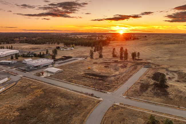
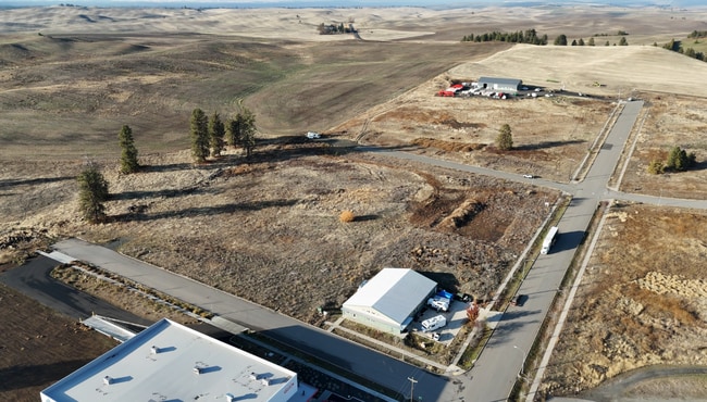
1635 Spring St, Cheney, WA 99004

This Property Is For Sale
NEARBY LISTINGS FOR SALE OR LEASE
-
-
View all Cheney listings for sale on LoopNet.com
Property Detail
1635 Spring St
Spokane-Spokane Valley, WA
23-23-41: LOT 9, BLOCK 2 OF THE CHENEY BINDING SITE PLAN NO. 02-08, RECORDED IN BOOK 3 OF BINDING SITE PLANS, PAGE 34, AFN 5915095. TOGETHER WITH A PORTION OF PARCEL B AS SHOWN ON THE RECORD OF SURVEY FOR BOUNDARY LINE ADJUSTMENT FILED IN BOOK 170 OF
13232.0293
Spokane
Vacantlandnec
Washington
X
9
53063C0875D
1.77 AC
2025
West Plains
2025
Spokane
014002
DEMOGRAPHICS near 1635 Spring St
1 Mile
3 Mile
5 Mile
2024 Total Population
2,219
14,798
16,098
2029 Population
2,369
15,938
17,331
Pop Growth 2024-2029
+ 6.76%
+ 7.70%
+ 7.66%
Average Age
35
32
33
2024 Total Households
926
5,583
6,077
HH Growth 2024-2029
+ 6.70%
+ 8.33%
+ 8.26%
Median Household Inc
$61,272
$46,628
$50,300
Avg Household Size
2.30
2.30
2.30
2024 Avg HH Vehicles
2.00
2.00
2.00
Median Home Value
$335,251
$411,715
$420,225
Median Year Built
1976
1987
1988
Nearby Places
- Restaurants
- Banks
- Shops
- Fitness
- Groceries
PUBLIC TRANSPORTATION
AIRPORT
Spokane International
DRIVE
WALK
Distance
Spokane International
25 min
15.4 mi
Freight Ports
Port of Everett
DRIVE
WALK
Distance
Port of Everett
326 min
287.9 mi
Nearby Properties
Address
Land Use
TOTAL SIZE
Lot Size
Zoning
Address
Land Use
TOTAL SIZE
Lot Size
Zoning
410,897 SF
4.38 AC
P
Address
Land Use
TOTAL SIZE
Lot Size
Zoning
375,519 SF
16.62 AC
P
Address
Land Use
TOTAL SIZE
Lot Size
Zoning
265,676 SF
25.25 AC
R-1
Address
Land Use
TOTAL SIZE
Lot Size
Zoning
306,250 SF
16.11 AC
LI
Address
Land Use
TOTAL SIZE
Lot Size
Zoning
182,817 SF
13.20 AC
R-3
Address
Land Use
TOTAL SIZE
Lot Size
Zoning
312,332 SF
4.06 AC
P
Address
Land Use
TOTAL SIZE
Lot Size
Zoning
249,952 SF
19.34 AC
R-3
Address
Land Use
TOTAL SIZE
Lot Size
Zoning
228,269 SF
9.43 AC
P
Address
Land Use
TOTAL SIZE
Lot Size
Zoning
196,902 SF
17.05 AC
P
Address
Land Use
TOTAL SIZE
Lot Size
Zoning
61,142 SF
13 AC
R-3H
Address
Land Use
TOTAL SIZE
Lot Size
Zoning
68,755 SF
100 AC
P
Address
Land Use
TOTAL SIZE
Lot Size
Zoning
129,310 SF
34.99 AC
R-1
Address
Land Use
TOTAL SIZE
Lot Size
Zoning
165,284 SF
1.65 AC
P
Address
Land Use
TOTAL SIZE
Lot Size
Zoning
142,588 SF
9.16 AC
R-3
Address
Land Use
TOTAL SIZE
Lot Size
Zoning
106,944 SF
1.89 AC
R-3H
Address
Land Use
TOTAL SIZE
Lot Size
Zoning
46,761 SF
3.09 AC
P
Address
Land Use
TOTAL SIZE
Lot Size
Zoning
66,489 SF
2.34 AC
P
Address
Land Use
TOTAL SIZE
Lot Size
Zoning
33,440 SF
2.59 AC
P
Address
Land Use
TOTAL SIZE
Lot Size
Zoning
109,528 SF
4.17 AC
R-3
Address
Land Use
TOTAL SIZE
Lot Size
Zoning
202,449 SF
23.29 AC
I-1
Address
Land Use
TOTAL SIZE
Lot Size
Zoning
49,872 SF
1.88 AC
P
Address
Land Use
TOTAL SIZE
Lot Size
Zoning
40,361 SF
2.54 AC
C-2
Address
Land Use
TOTAL SIZE
Lot Size
Zoning
55,047 SF
1.26 AC
R-3H
Address
Land Use
TOTAL SIZE
Lot Size
Zoning
81,628 SF
11.88 AC
C-2
Address
Land Use
TOTAL SIZE
Lot Size
Zoning
40,541 SF
3.85 AC
R-3H
Address
Land Use
TOTAL SIZE
Lot Size
Zoning
97,585 SF
0.57 AC
P
Address
Land Use
TOTAL SIZE
Lot Size
Zoning
74,769 SF
2.11 AC
P
Address
Land Use
TOTAL SIZE
Lot Size
Zoning
95,120 SF
4 AC
R-3
Address
Land Use
TOTAL SIZE
Lot Size
Zoning
71,708 SF
4.35 AC
R-3H
Address
Land Use
TOTAL SIZE
Lot Size
Zoning
19,088 SF
2.19 AC
P
The World's #1 Commercial Real Estate Marketplace
Connect with us
© 2025 CoStar Group
The information above has been obtained from sources believed reliable. While we do not doubt its accuracy we have not verified it and make no guarantee, warranty or representation about it. It is your responsibility to independently confirm its accuracy and completeness. Any projections, opinions, assumptions, or estimates used are for example only and do not represent the current or future performance of the property. The value of this transaction to you depends on tax and other factors which should be evaluated by your tax, financial, and legal advisors. You and your advisors should conduct a careful, independent investigation of the property to determine to your satisfaction the suitability of the property for your needs.