Property Record
16361 N Highway 75, Willis, TX 77378
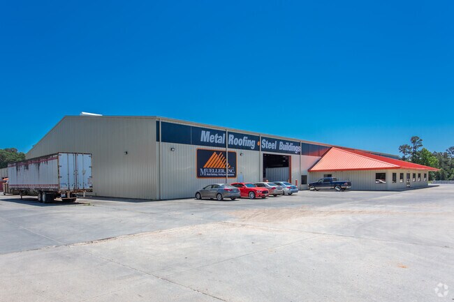

Property Detail
16361 N Highway 75
0262-00-02700
A0262 HULON WM H, TRACT 27, ACRES 9.5972
Industrialgeneral
MONTGOMERY
4
Texas
B and X Area of moderate flood hazard, usually the area between the limits of the 100-year and 500-year floods.
9.60 AC
2024
The Woodlands/Conroe
2025
Houston
694106
Houston-Pasadena-The Woodlands, TX
102,250 SF
NEARBY LISTINGS FOR SALE OR LEASE
-
-
View all Willis listings for sale on LoopNet.com
DEMOGRAPHICS near 16361 N Highway 75
1 mile
3 mile
5 mile
2025 Total Population
864
9,974
30,603
2030 Population
1,020
11,822
36,178
Pop Growth 2025-2030
+ 18.06%
+ 18.53%
+ 18.22%
Average Age
39
38
39
2025 Total Households
289
3,525
10,943
HH Growth 2025-2030
+ 18.69%
+ 19.09%
+ 18.72%
Median Household Inc
$82,363
$73,337
$74,803
Avg Household Size
2.90
2.80
2.80
2025 Avg HH Vehicles
2.00
2.00
2.00
Median Home Value
$457,368
$240,000
$258,592
Median Year Built
2010
1999
2001
Nearby Places
Map Layers
Map Styles
 Street
 Aerial
Layers
 Traffic
 Biking
Places
Listings with unknown addresses are not visible on the map
- Restaurants
- Banks
- Shops
- Fitness
- Groceries
Nearby Properties
Address
Land Use
TOTAL SIZE
Lot Size
Zoning
Address
Land Use
TOTAL SIZE
Lot Size
Zoning
9,491 SF
164.51 AC
Address
Land Use
TOTAL SIZE
Lot Size
Zoning
265,346 SF
74.32 AC
4
Address
Land Use
TOTAL SIZE
Lot Size
Zoning
34,832 SF
31.27 AC
Address
Land Use
TOTAL SIZE
Lot Size
Zoning
31,078 SF
14.11 AC
4
Address
Land Use
TOTAL SIZE
Lot Size
Zoning
33,867 SF
41.93 AC
4
Address
Land Use
TOTAL SIZE
Lot Size
Zoning
29,311 SF
9.09 AC
4
Address
Land Use
TOTAL SIZE
Lot Size
Zoning
4,420 SF
21.95 AC
4
Address
Land Use
TOTAL SIZE
Lot Size
Zoning
17,048 SF
11.80 AC
4
Address
Land Use
TOTAL SIZE
Lot Size
Zoning
41,158 SF
33.75 AC
4
Address
Land Use
TOTAL SIZE
Lot Size
Zoning
78,300 SF
10 AC
Address
Land Use
TOTAL SIZE
Lot Size
Zoning
16,268 SF
4.37 AC
Address
Land Use
TOTAL SIZE
Lot Size
Zoning
52,896 SF
31.64 AC
4
Address
Land Use
TOTAL SIZE
Lot Size
Zoning
20,222 SF
6.38 AC
Address
Land Use
TOTAL SIZE
Lot Size
Zoning
1,184 SF
164.38 AC
4
Address
Land Use
TOTAL SIZE
Lot Size
Zoning
52,630 SF
4.73 AC
4
Address
Land Use
TOTAL SIZE
Lot Size
Zoning
13,100 SF
14.03 AC
Address
Land Use
TOTAL SIZE
Lot Size
Zoning
41,296 SF
4.06 AC
4
Address
Land Use
TOTAL SIZE
Lot Size
Zoning
33,130 SF
7.40 AC
Address
Land Use
TOTAL SIZE
Lot Size
Zoning
17,236 SF
6.74 AC
4
Address
Land Use
TOTAL SIZE
Lot Size
Zoning
21,768 SF
20.98 AC
4
Address
Land Use
TOTAL SIZE
Lot Size
Zoning
14,835 SF
3.78 AC
4
Address
Land Use
TOTAL SIZE
Lot Size
Zoning
29,620 SF
23.56 AC
4
Address
Land Use
TOTAL SIZE
Lot Size
Zoning
512 SF
31.82 AC
4
Address
Land Use
TOTAL SIZE
Lot Size
Zoning
9,375 SF
24 AC
4
Address
Land Use
TOTAL SIZE
Lot Size
Zoning
13,795 SF
7.92 AC
4
Address
Land Use
TOTAL SIZE
Lot Size
Zoning
5,500 SF
7.35 AC
4
Address
Land Use
TOTAL SIZE
Lot Size
Zoning
18,830 SF
5.77 AC
4
Address
Land Use
TOTAL SIZE
Lot Size
Zoning
30,125 SF
10.93 AC
Address
Land Use
TOTAL SIZE
Lot Size
Zoning
6,720 SF
2.25 AC
4
The World's #1 Commercial Real Estate Marketplace
Connect with us
© 2026 CoStar Group
The information above has been obtained from sources believed reliable. While we do not doubt its accuracy we have not verified it and make no guarantee, warranty or representation about it. It is your responsibility to independently confirm its accuracy and completeness. Any projections, opinions, assumptions, or estimates used are for example only and do not represent the current or future performance of the property. The value of this transaction to you depends on tax and other factors which should be evaluated by your tax, financial, and legal advisors. You and your advisors should conduct a careful, independent investigation of the property to determine to your satisfaction the suitability of the property for your needs.