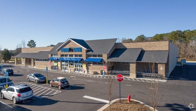
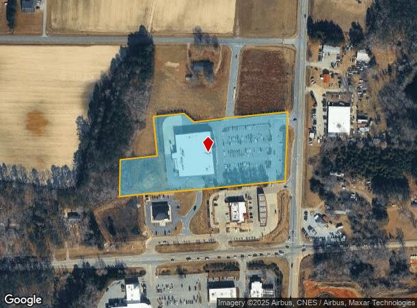
Property Record
16363 Nc Highway 50 N, Garner, NC 27529

NEARBY LISTINGS FOR SALE OR LEASE
-
-
View all Garner listings for sale on LoopNet.com
Property Detail
16363 Nc Highway 50 N
06D01020K
LOT 1 BRACK PENNY RD LP 90/225
Supermarket
Johnston
X
North Carolina
3720161700L
1
2025
5.20 AC
2025
Johnston County
041112
Raleigh/Durham
34,770 SF
Raleigh, NC
DEMOGRAPHICS near 16363 Nc Highway 50 N
1 Mile
3 Mile
5 Mile
2024 Total Population
2,268
22,509
58,306
2029 Population
2,699
26,395
67,799
Pop Growth 2024-2029
+ 19.00%
+ 17.26%
+ 16.28%
Average Age
39
39
39
2024 Total Households
821
8,181
20,916
HH Growth 2024-2029
+ 19.00%
+ 17.25%
+ 16.28%
Median Household Inc
$100,820
$90,889
$91,115
Avg Household Size
2.70
2.70
2.70
2024 Avg HH Vehicles
2.00
2.00
2.00
Median Home Value
$330,937
$306,073
$306,835
Median Year Built
2010
2004
2002
Nearby Places
Map Layers
Map Styles
 Street
 Aerial
- Restaurants
- Banks
- Shops
- Fitness
- Groceries
PUBLIC TRANSPORTATION
AIRPORT
Raleigh-Durham International
DRIVE
WALK
Distance
Raleigh-Durham International
42 min
32.4 mi
Freight Ports
Port of Wilmington
DRIVE
WALK
Distance
Port of Wilmington
138 min
118.3 mi
Nearby Properties
Address
Land Use
TOTAL SIZE
Lot Size
Zoning
Address
Land Use
TOTAL SIZE
Lot Size
Zoning
6,769 SF
13.68 AC
COM
Address
Land Use
TOTAL SIZE
Lot Size
Zoning
24,684 SF
11.64 AC
COM
Address
Land Use
TOTAL SIZE
Lot Size
Zoning
15,231 SF
12.07 AC
COM
Address
Land Use
TOTAL SIZE
Lot Size
Zoning
65,000 SF
22.17 AC
IND
Address
Land Use
TOTAL SIZE
Lot Size
Zoning
196,425 SF
40.89 AC
COP
Address
Land Use
TOTAL SIZE
Lot Size
Zoning
15,500 SF
34.65 AC
RAG
Address
Land Use
TOTAL SIZE
Lot Size
Zoning
56,411 SF
9.29 AC
COP
Address
Land Use
TOTAL SIZE
Lot Size
Zoning
134,927 SF
24.97 AC
COM
Address
Land Use
TOTAL SIZE
Lot Size
Zoning
50,400 SF
5.24 AC
COM
Address
Land Use
TOTAL SIZE
Lot Size
Zoning
75,092 SF
3.56 AC
CU-HC
Address
Land Use
TOTAL SIZE
Lot Size
Zoning
1,856 SF
3.52 AC
COM
Address
Land Use
TOTAL SIZE
Lot Size
Zoning
30.80 AC
COM
Address
Land Use
TOTAL SIZE
Lot Size
Zoning
42,662 SF
3.48 AC
COM
Address
Land Use
TOTAL SIZE
Lot Size
Zoning
70,792 SF
10.02 AC
COM
Address
Land Use
TOTAL SIZE
Lot Size
Zoning
56,083 SF
6.50 AC
COM
Address
Land Use
TOTAL SIZE
Lot Size
Zoning
37,086 SF
6.50 AC
COM
Address
Land Use
TOTAL SIZE
Lot Size
Zoning
50,752 SF
2.11 AC
COM
Address
Land Use
TOTAL SIZE
Lot Size
Zoning
30,368 SF
3.83 AC
RAG
Address
Land Use
TOTAL SIZE
Lot Size
Zoning
18,504 SF
7.38 AC
COM
Address
Land Use
TOTAL SIZE
Lot Size
Zoning
750 SF
7.91 AC
COM
Address
Land Use
TOTAL SIZE
Lot Size
Zoning
35,710 SF
1.84 AC
COM
Address
Land Use
TOTAL SIZE
Lot Size
Zoning
36,456 SF
2.06 AC
COM
Address
Land Use
TOTAL SIZE
Lot Size
Zoning
28,940 SF
8.83 AC
COP
Address
Land Use
TOTAL SIZE
Lot Size
Zoning
9,399 SF
9.44 AC
COM
Address
Land Use
TOTAL SIZE
Lot Size
Zoning
20,292 SF
1.46 AC
COM
Address
Land Use
TOTAL SIZE
Lot Size
Zoning
55.89 AC
COM
Address
Land Use
TOTAL SIZE
Lot Size
Zoning
19,932 SF
5.48 AC
COM
Address
Land Use
TOTAL SIZE
Lot Size
Zoning
35,350 SF
2 AC
COM
Address
Land Use
TOTAL SIZE
Lot Size
Zoning
21,441 SF
4.32 AC
COM
The World's #1 Commercial Real Estate Marketplace
Connect with us
© 2025 CoStar Group
The information above has been obtained from sources believed reliable. While we do not doubt its accuracy we have not verified it and make no guarantee, warranty or representation about it. It is your responsibility to independently confirm its accuracy and completeness. Any projections, opinions, assumptions, or estimates used are for example only and do not represent the current or future performance of the property. The value of this transaction to you depends on tax and other factors which should be evaluated by your tax, financial, and legal advisors. You and your advisors should conduct a careful, independent investigation of the property to determine to your satisfaction the suitability of the property for your needs.