Property Record
1637 Athens Hwy, Grayson, GA 30017
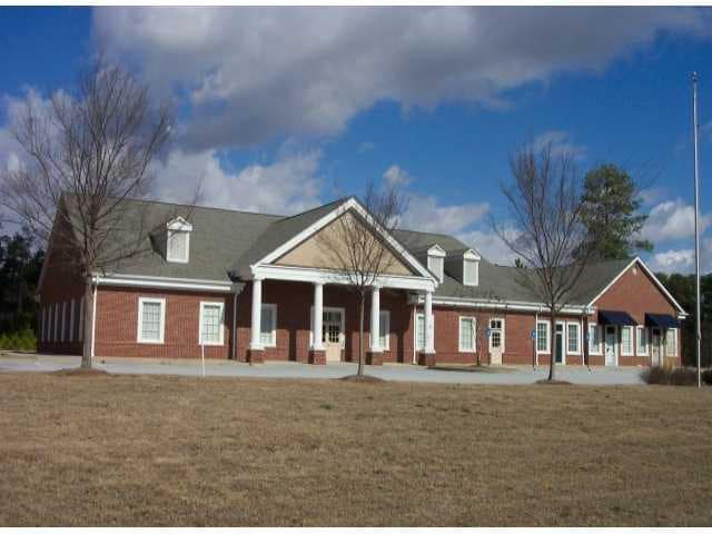


This Property Is For Sale
Property Detail
1637 Athens Hwy
5-069-278
TR A & B HWY 78
Officebuilding
Gwinnett
C2
Georgia
B and X Area of moderate flood hazard, usually the area between the limits of the 100-year and 500-year floods.
b
2025
1.10 AC
2025
Lawrenceville/Lilburn
050755
Atlanta
10,694 SF
Atlanta-Sandy Springs-Roswell, GA
NEARBY LISTINGS FOR SALE OR LEASE
DEMOGRAPHICS near 1637 Athens Hwy
1 mile
3 mile
5 mile
2025 Total Population
8,207
59,852
164,734
2030 Population
8,592
63,274
173,520
Pop Growth 2025-2030
+ 4.69%
+ 5.72%
+ 5.33%
Average Age
39
39
39
2025 Total Households
2,706
19,476
52,689
HH Growth 2025-2030
+ 4.80%
+ 5.78%
+ 5.43%
Median Household Inc
$86,574
$89,085
$94,699
Avg Household Size
3.00
3.00
3.10
2025 Avg HH Vehicles
2.00
2.00
2.00
Median Home Value
$345,287
$372,754
$383,998
Median Year Built
1998
1997
1997
Nearby Places
Map Layers
Map Styles
 Street
 Aerial
Transit
 Traffic
 Biking
Places
Listings with unknown addresses are not visible on the map
- Restaurants
- Banks
- Shops
- Fitness
- Groceries
PUBLIC TRANSPORTATION
AIRPORT
Hartsfield - Jackson Atlanta International
Drive
Walk
Distance
Hartsfield - Jackson Atlanta International
54 min
35.3 mi
Nearby Properties
Address
Land Use
TOTAL SIZE
Lot Size
Zoning
Address
Land Use
TOTAL SIZE
Lot Size
Zoning
362,674 SF
43.59 AC
CI
Address
Land Use
TOTAL SIZE
Lot Size
Zoning
349,060 SF
59.85 AC
R100
Address
Land Use
TOTAL SIZE
Lot Size
Zoning
469,566 SF
24.30 AC
RS180
Address
Land Use
TOTAL SIZE
Lot Size
Zoning
319,290 SF
2.05 AC
TC-MU
Address
Land Use
TOTAL SIZE
Lot Size
Zoning
245,208 SF
15.37 AC
RO
Address
Land Use
TOTAL SIZE
Lot Size
Zoning
274,964 SF
27.82 AC
BG
Address
Land Use
TOTAL SIZE
Lot Size
Zoning
214,399 SF
29.91 AC
C2
Address
Land Use
TOTAL SIZE
Lot Size
Zoning
230,417 SF
24.09 AC
BG
Address
Land Use
TOTAL SIZE
Lot Size
Zoning
189,254 SF
40 AC
R100
Address
Land Use
TOTAL SIZE
Lot Size
Zoning
214,082 SF
18.56 AC
BG
Address
Land Use
TOTAL SIZE
Lot Size
Zoning
283,953 SF
20.56 AC
RS30
Address
Land Use
TOTAL SIZE
Lot Size
Zoning
162,474 SF
41 AC
R100
Address
Land Use
TOTAL SIZE
Lot Size
Zoning
186,309 SF
15.53 AC
RM
Address
Land Use
TOTAL SIZE
Lot Size
Zoning
125,097 SF
1.01 AC
CI
Address
Land Use
TOTAL SIZE
Lot Size
Zoning
196,333 SF
23.27 AC
RS180
Address
Land Use
TOTAL SIZE
Lot Size
Zoning
107,829 SF
7.82 AC
RM
Address
Land Use
TOTAL SIZE
Lot Size
Zoning
202,864 SF
1.35 AC
TC-MU
Address
Land Use
TOTAL SIZE
Lot Size
Zoning
131,121 SF
12.99 AC
BG
Address
Land Use
TOTAL SIZE
Lot Size
Zoning
218,973 SF
21.04 AC
BG
Address
Land Use
TOTAL SIZE
Lot Size
Zoning
79,339 SF
38.25 AC
RS180
Address
Land Use
TOTAL SIZE
Lot Size
Zoning
120,113 SF
13 AC
BG
Address
Land Use
TOTAL SIZE
Lot Size
Zoning
108,123 SF
13.96 AC
R100
Address
Land Use
TOTAL SIZE
Lot Size
Zoning
122,201 SF
10.23 AC
BG
Address
Land Use
TOTAL SIZE
Lot Size
Zoning
100,913 SF
8.30 AC
HSB
Address
Land Use
TOTAL SIZE
Lot Size
Zoning
97,411 SF
8.47 AC
BG
Address
Land Use
TOTAL SIZE
Lot Size
Zoning
111,732 SF
9.71 AC
CI
Address
Land Use
TOTAL SIZE
Lot Size
Zoning
82,809 SF
21.79 AC
R100
Address
Land Use
TOTAL SIZE
Lot Size
Zoning
61,200 SF
0.59 AC
CI
Address
Land Use
TOTAL SIZE
Lot Size
Zoning
66,544 SF
6.70 AC
BG
Address
Land Use
TOTAL SIZE
Lot Size
Zoning
103,660 SF
9.58 AC
BG
The World's #1 Commercial Real Estate Marketplace
Connect with us
© 2026 CoStar Group
The information above has been obtained from sources believed reliable. While we do not doubt its accuracy we have not verified it and make no guarantee, warranty or representation about it. It is your responsibility to independently confirm its accuracy and completeness. Any projections, opinions, assumptions, or estimates used are for example only and do not represent the current or future performance of the property. The value of this transaction to you depends on tax and other factors which should be evaluated by your tax, financial, and legal advisors. You and your advisors should conduct a careful, independent investigation of the property to determine to your satisfaction the suitability of the property for your needs.