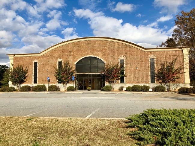
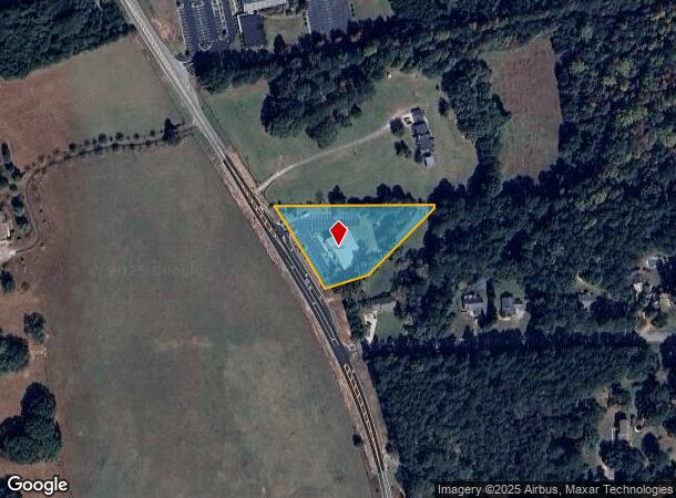
Property Record
1637 Highway 154, Sharpsburg, GA 30277

NEARBY LISTINGS FOR SALE OR LEASE
-
-
View all Sharpsburg listings for sale on LoopNet.com
Property Detail
1637 Highway 154
122-6066-004A
CHURCH/1.61 AC LL 66 6LD PARCEL A
Religious
Coweta
X
Georgia
13077C0170D
66
0
1.61 AC
2025
Fayette/Coweta County
170501
Atlanta
7,000 SF
Atlanta-Sandy Springs-Roswell, GA
DEMOGRAPHICS near 1637 Highway 154
1 Mile
3 Mile
5 Mile
2024 Total Population
1,187
22,451
59,674
2029 Population
1,315
25,045
65,885
Pop Growth 2024-2029
+ 10.78%
+ 11.55%
+ 10.41%
Average Age
42
41
41
2024 Total Households
428
8,107
21,985
HH Growth 2024-2029
+ 11.21%
+ 11.64%
+ 10.48%
Median Household Inc
$104,619
$99,416
$100,713
Avg Household Size
2.70
2.70
2.70
2024 Avg HH Vehicles
2.00
2.00
2.00
Median Home Value
$271,068
$268,196
$294,513
Median Year Built
1994
1996
1998
Nearby Places
- Restaurants
- Banks
- Shops
- Fitness
- Groceries
PUBLIC TRANSPORTATION
AIRPORT
Hartsfield - Jackson Atlanta International
DRIVE
WALK
Distance
Hartsfield - Jackson Atlanta International
38 min
29.1 mi
Freight Ports
Georgia Ports - Savannah
DRIVE
WALK
Distance
Georgia Ports - Savannah
287 min
246.0 mi
SALE & LEASE HISTORY
LISTING DATE
SALE/LEASE

Jun 14, 2018
For Sale
Dec 05, 2017
For Sale
Nearby Properties
Address
Land Use
TOTAL SIZE
Lot Size
Zoning
Address
Land Use
TOTAL SIZE
Lot Size
Zoning
166,866 SF
85.16 AC
R1
Address
Land Use
TOTAL SIZE
Lot Size
Zoning
112,934 SF
108.27 AC
R1
Address
Land Use
TOTAL SIZE
Lot Size
Zoning
117,354 SF
48.81 AC
ND
Address
Land Use
TOTAL SIZE
Lot Size
Zoning
90,675 SF
20.42 AC
001
Address
Land Use
TOTAL SIZE
Lot Size
Zoning
71,888 SF
23.48 AC
R1
Address
Land Use
TOTAL SIZE
Lot Size
Zoning
47,598 SF
4.29 AC
C
Address
Land Use
TOTAL SIZE
Lot Size
Zoning
121,290 SF
11.74 AC
R1
Address
Land Use
TOTAL SIZE
Lot Size
Zoning
59,250 SF
8.77 AC
R1
Address
Land Use
TOTAL SIZE
Lot Size
Zoning
91,629 SF
23.51 AC
R1
Address
Land Use
TOTAL SIZE
Lot Size
Zoning
112,650 SF
5.70 AC
002
Address
Land Use
TOTAL SIZE
Lot Size
Zoning
137,702 SF
17.39 AC
R1
Address
Land Use
TOTAL SIZE
Lot Size
Zoning
25,600 SF
131.86 AC
R1
Address
Land Use
TOTAL SIZE
Lot Size
Zoning
89,260 SF
10.26 AC
001
Address
Land Use
TOTAL SIZE
Lot Size
Zoning
90,474 SF
12.56 AC
C
Address
Land Use
TOTAL SIZE
Lot Size
Zoning
28,753 SF
4.83 AC
R1
Address
Land Use
TOTAL SIZE
Lot Size
Zoning
25,372 SF
2.27 AC
001
Address
Land Use
TOTAL SIZE
Lot Size
Zoning
103,594 SF
18.83 AC
R1
Address
Land Use
TOTAL SIZE
Lot Size
Zoning
47,540 SF
6.33 AC
R1
Address
Land Use
TOTAL SIZE
Lot Size
Zoning
28,560 SF
10.91 AC
R1
Address
Land Use
TOTAL SIZE
Lot Size
Zoning
80,564 SF
16.23 AC
R1
Address
Land Use
TOTAL SIZE
Lot Size
Zoning
31,794 SF
2.65 AC
R1
Address
Land Use
TOTAL SIZE
Lot Size
Zoning
98,838 SF
8.18 AC
R1
Address
Land Use
TOTAL SIZE
Lot Size
Zoning
67,604 SF
29.71 AC
R1
Address
Land Use
TOTAL SIZE
Lot Size
Zoning
41,355 SF
25.21 AC
R1
Address
Land Use
TOTAL SIZE
Lot Size
Zoning
59,753 SF
8.77 AC
R1
Address
Land Use
TOTAL SIZE
Lot Size
Zoning
23,561 SF
11.75 AC
R1
Address
Land Use
TOTAL SIZE
Lot Size
Zoning
28,683 SF
33.64 AC
R1
Address
Land Use
TOTAL SIZE
Lot Size
Zoning
7,117 SF
2.26 AC
R1
Address
Land Use
TOTAL SIZE
Lot Size
Zoning
6,375 SF
1.62 AC
R1
Address
Land Use
TOTAL SIZE
Lot Size
Zoning
11,876 SF
1.97 AC
001
The World's #1 Commercial Real Estate Marketplace
Connect with us
© 2025 CoStar Group
The information above has been obtained from sources believed reliable. While we do not doubt its accuracy we have not verified it and make no guarantee, warranty or representation about it. It is your responsibility to independently confirm its accuracy and completeness. Any projections, opinions, assumptions, or estimates used are for example only and do not represent the current or future performance of the property. The value of this transaction to you depends on tax and other factors which should be evaluated by your tax, financial, and legal advisors. You and your advisors should conduct a careful, independent investigation of the property to determine to your satisfaction the suitability of the property for your needs.