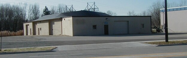
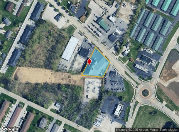
Property Record
1637 Velp Ave, Green Bay, WI 54303

NEARBY LISTINGS FOR SALE OR LEASE
Property Detail
1637 Velp Ave
Green Bay, WI
Military Reserve
VH-569-1
0.996 AC M/L FORT HOWARD MILITARY RESERVE THAT PRT OF LOT 59 DES IN 654 R 317 EX HWY & EX PARCEL 183 OF TPP 1450- O6-21-4.02
Commercialnec
Brown
X
Wisconsin
55009C0166G
59
2024
1 AC
2024
Green Bay
020502
Green Bay
DEMOGRAPHICS near 1637 Velp Ave
1 Mile
3 Mile
5 Mile
2024 Total Population
5,355
48,423
117,538
2029 Population
5,438
49,362
119,897
Pop Growth 2024-2029
+ 1.55%
+ 1.94%
+ 2.01%
Average Age
38
40
39
2024 Total Households
2,564
21,281
49,238
HH Growth 2024-2029
+ 1.56%
+ 1.95%
+ 2.08%
Median Household Inc
$46,401
$52,548
$57,813
Avg Household Size
2.10
2.20
2.30
2024 Avg HH Vehicles
2.00
2.00
2.00
Median Home Value
$167,495
$167,841
$184,913
Median Year Built
1979
1967
1971
Nearby Places
Map Layers
Map Styles
 Street
 Aerial
- Restaurants
- Banks
- Shops
- Fitness
- Groceries
PUBLIC TRANSPORTATION
AIRPORT
Green Bay/Austin Straubel International
DRIVE
WALK
Distance
Green Bay/Austin Straubel International
15 min
9.3 mi
Freight Ports
Port Milwaukee
DRIVE
WALK
Distance
Port Milwaukee
140 min
122.3 mi
Nearby Properties
Address
Land Use
TOTAL SIZE
Lot Size
Zoning
Address
Land Use
TOTAL SIZE
Lot Size
Zoning
36.49 AC
Address
Land Use
TOTAL SIZE
Lot Size
Zoning
6.32 AC
R1
Address
Land Use
TOTAL SIZE
Lot Size
Zoning
96.49 AC
Address
Land Use
TOTAL SIZE
Lot Size
Zoning
5.44 AC
Address
Land Use
TOTAL SIZE
Lot Size
Zoning
25.70 AC
Address
Land Use
TOTAL SIZE
Lot Size
Zoning
15.62 AC
Address
Land Use
TOTAL SIZE
Lot Size
Zoning
16.07 AC
Address
Land Use
TOTAL SIZE
Lot Size
Zoning
23.29 AC
Address
Land Use
TOTAL SIZE
Lot Size
Zoning
18.14 AC
Address
Land Use
TOTAL SIZE
Lot Size
Zoning
27.20 AC
Address
Land Use
TOTAL SIZE
Lot Size
Zoning
6.60 AC
Address
Land Use
TOTAL SIZE
Lot Size
Zoning
18.69 AC
Address
Land Use
TOTAL SIZE
Lot Size
Zoning
17.66 AC
Address
Land Use
TOTAL SIZE
Lot Size
Zoning
16.74 AC
Address
Land Use
TOTAL SIZE
Lot Size
Zoning
Address
Land Use
TOTAL SIZE
Lot Size
Zoning
0.74 AC
Address
Land Use
TOTAL SIZE
Lot Size
Zoning
0.63 AC
Address
Land Use
TOTAL SIZE
Lot Size
Zoning
1.25 AC
Address
Land Use
TOTAL SIZE
Lot Size
Zoning
28.20 AC
Address
Land Use
TOTAL SIZE
Lot Size
Zoning
0.48 AC
Address
Land Use
TOTAL SIZE
Lot Size
Zoning
12.17 AC
Address
Land Use
TOTAL SIZE
Lot Size
Zoning
81,981 SF
0.80 AC
D2
Address
Land Use
TOTAL SIZE
Lot Size
Zoning
20.25 AC
Address
Land Use
TOTAL SIZE
Lot Size
Zoning
Address
Land Use
TOTAL SIZE
Lot Size
Zoning
320,146 SF
48.50 AC
GI, R1
Address
Land Use
TOTAL SIZE
Lot Size
Zoning
268,880 SF
23.35 AC
GI
Address
Land Use
TOTAL SIZE
Lot Size
Zoning
83.31 AC
Address
Land Use
TOTAL SIZE
Lot Size
Zoning
5.77 AC
Address
Land Use
TOTAL SIZE
Lot Size
Zoning
4.60 AC
Address
Land Use
TOTAL SIZE
Lot Size
Zoning
936 SF
3.09 AC
R1
The World's #1 Commercial Real Estate Marketplace
Connect with us
© 2025 CoStar Group
The information above has been obtained from sources believed reliable. While we do not doubt its accuracy we have not verified it and make no guarantee, warranty or representation about it. It is your responsibility to independently confirm its accuracy and completeness. Any projections, opinions, assumptions, or estimates used are for example only and do not represent the current or future performance of the property. The value of this transaction to you depends on tax and other factors which should be evaluated by your tax, financial, and legal advisors. You and your advisors should conduct a careful, independent investigation of the property to determine to your satisfaction the suitability of the property for your needs.