Property Record
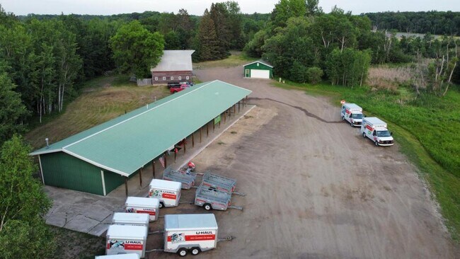
16396 State Highway 371, Brainerd, MN 56401

Property Detail
16396 State Highway 371
970303200AB0009
THAT PART OF N. 1/2 OF SW1/4 SEC. 30 DESCRIBED AS FOLLOWS; BEG. AT THE W. QUARTER CORNER OF SAID SEC
Commercialnec
Crow Wing
B and X Area of moderate flood hazard, usually the area between the limits of the 100-year and 500-year floods.
Minnesota
2026
9.98 AC
2025
Minnesota Central Area
950901
Other Market Areas
1,695 SF
Brainerd, MN
NEARBY LISTINGS FOR SALE OR LEASE
DEMOGRAPHICS near 16396 State Highway 371
1 mile
3 mile
5 mile
2025 Total Population
180
6,434
25,123
2030 Population
184
6,430
24,968
Pop Growth 2025-2030
+ 2.22%
(0.06%)
(0.62%)
Average Age
43
42
41
2025 Total Households
69
2,554
10,215
HH Growth 2025-2030
+ 2.90%
(0.12%)
(0.75%)
Median Household Inc
$113,888
$77,237
$70,851
Avg Household Size
2.60
2.40
2.30
2025 Avg HH Vehicles
2.00
2.00
2.00
Median Home Value
$350,000
$332,334
$296,530
Median Year Built
1998
1999
1985
Nearby Places
Map Layers
Map Styles
 Street
 Aerial
Layers
 Traffic
 Biking
Places
Listings with unknown addresses are not visible on the map
- Restaurants
- Banks
- Shops
- Fitness
- Groceries
SALE & LEASE HISTORY
LISTING DATE
SALE/LEASE

Jun 12, 2021
For Sale
Nearby Properties
Address
Land Use
TOTAL SIZE
Lot Size
Zoning
Address
Land Use
TOTAL SIZE
Lot Size
Zoning
83,078 SF
9.71 AC
Address
Land Use
TOTAL SIZE
Lot Size
Zoning
2,516 SF
364.73 AC
Address
Land Use
TOTAL SIZE
Lot Size
Zoning
65,502 SF
4.39 AC
Address
Land Use
TOTAL SIZE
Lot Size
Zoning
147,137 SF
16.34 AC
Address
Land Use
TOTAL SIZE
Lot Size
Zoning
270,176 SF
17.13 AC
Address
Land Use
TOTAL SIZE
Lot Size
Zoning
64,187 SF
3.47 AC
Address
Land Use
TOTAL SIZE
Lot Size
Zoning
66,967 SF
2.95 AC
Address
Land Use
TOTAL SIZE
Lot Size
Zoning
167,226 SF
24.08 AC
Address
Land Use
TOTAL SIZE
Lot Size
Zoning
38,487 SF
2.78 AC
Address
Land Use
TOTAL SIZE
Lot Size
Zoning
68,564 SF
3.41 AC
Address
Land Use
TOTAL SIZE
Lot Size
Zoning
68,643 SF
2.34 AC
Address
Land Use
TOTAL SIZE
Lot Size
Zoning
57,426 SF
2.61 AC
Address
Land Use
TOTAL SIZE
Lot Size
Zoning
15,388 SF
6.30 AC
Address
Land Use
TOTAL SIZE
Lot Size
Zoning
17,516 SF
3.46 AC
Address
Land Use
TOTAL SIZE
Lot Size
Zoning
28,169 SF
45.83 AC
Address
Land Use
TOTAL SIZE
Lot Size
Zoning
86,796 SF
10.34 AC
Address
Land Use
TOTAL SIZE
Lot Size
Zoning
65,997 SF
6.43 AC
Address
Land Use
TOTAL SIZE
Lot Size
Zoning
116,200 SF
9.14 AC
Address
Land Use
TOTAL SIZE
Lot Size
Zoning
125,156 SF
13.35 AC
Address
Land Use
TOTAL SIZE
Lot Size
Zoning
68,838 SF
2.23 AC
Address
Land Use
TOTAL SIZE
Lot Size
Zoning
40,728 SF
6.83 AC
Address
Land Use
TOTAL SIZE
Lot Size
Zoning
54,032 SF
5.45 AC
Address
Land Use
TOTAL SIZE
Lot Size
Zoning
19,348 SF
5.64 AC
Address
Land Use
TOTAL SIZE
Lot Size
Zoning
40,728 SF
3.09 AC
Address
Land Use
TOTAL SIZE
Lot Size
Zoning
88,695 SF
8.09 AC
The World's #1 Commercial Real Estate Marketplace
Connect with us
© 2026 CoStar Group
The information above has been obtained from sources believed reliable. While we do not doubt its accuracy we have not verified it and make no guarantee, warranty or representation about it. It is your responsibility to independently confirm its accuracy and completeness. Any projections, opinions, assumptions, or estimates used are for example only and do not represent the current or future performance of the property. The value of this transaction to you depends on tax and other factors which should be evaluated by your tax, financial, and legal advisors. You and your advisors should conduct a careful, independent investigation of the property to determine to your satisfaction the suitability of the property for your needs.