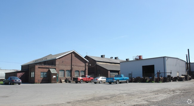
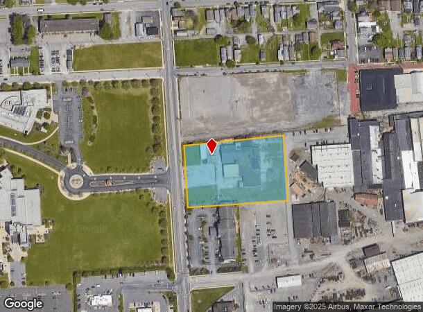
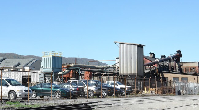
Property Record
164 Maynard St, Williamsport, PA 17701
NEARBY LISTINGS FOR SALE OR LEASE
Property Detail
164 Maynard St
Industrialacreage
Lycoming
X
Pennsylvania
42081C0432G
2.68 AC
2025
Pennsylvania Central Area
2025
Other Market Areas
000800
Williamsport, PA
12,132 SF
65-013.0-0400.00-000
DEMOGRAPHICS near 164 Maynard St
1 Mile
3 Mile
5 Mile
2024 Total Population
15,108
44,980
56,148
2029 Population
15,292
45,195
56,257
Pop Growth 2024-2029
+ 1.22%
+ 0.48%
+ 0.19%
Average Age
36
39
40
2024 Total Households
6,113
18,729
23,427
HH Growth 2024-2029
+ 1.42%
+ 0.47%
+ 0.17%
Median Household Inc
$38,423
$50,336
$53,244
Avg Household Size
2.10
2.20
2.20
2024 Avg HH Vehicles
1.00
2.00
2.00
Median Home Value
$141,515
$144,888
$156,188
Median Year Built
1953
1951
1956
Nearby Places
- Restaurants
- Banks
- Shops
- Fitness
- Groceries
SALE & LEASE HISTORY
LISTING DATE
SALE/LEASE

Jun 27, 2018
For Sale
Nearby Properties
Address
Land Use
TOTAL SIZE
Lot Size
Zoning
Address
Land Use
TOTAL SIZE
Lot Size
Zoning
230,400 SF
101.67 AC
INSR
Address
Land Use
TOTAL SIZE
Lot Size
Zoning
494,653 SF
61.63 AC
RESR
Address
Land Use
TOTAL SIZE
Lot Size
Zoning
90,171 SF
14.27 AC
Address
Land Use
TOTAL SIZE
Lot Size
Zoning
82,456 SF
16.06 AC
Address
Land Use
TOTAL SIZE
Lot Size
Zoning
15,680 SF
18.75 AC
INSR
Address
Land Use
TOTAL SIZE
Lot Size
Zoning
58,500 SF
28.92 AC
RESR
Address
Land Use
TOTAL SIZE
Lot Size
Zoning
11,760 SF
4.67 AC
RESR
Address
Land Use
TOTAL SIZE
Lot Size
Zoning
21,696 SF
5.69 AC
INSR
Address
Land Use
TOTAL SIZE
Lot Size
Zoning
19,250 SF
50 AC
4REA
Address
Land Use
TOTAL SIZE
Lot Size
Zoning
31,668 SF
2.50 AC
RESR
Address
Land Use
TOTAL SIZE
Lot Size
Zoning
12,740 SF
2.52 AC
04COR
Address
Land Use
TOTAL SIZE
Lot Size
Zoning
7,796 SF
43.87 AC
Address
Land Use
TOTAL SIZE
Lot Size
Zoning
16,568 SF
0.88 AC
04COC
Address
Land Use
TOTAL SIZE
Lot Size
Zoning
87,612 SF
9.11 AC
COMP
Address
Land Use
TOTAL SIZE
Lot Size
Zoning
46,711 SF
12.55 AC
COMC
Address
Land Use
TOTAL SIZE
Lot Size
Zoning
76,264 SF
9.55 AC
INDR
Address
Land Use
TOTAL SIZE
Lot Size
Zoning
3,111 SF
10,053.58 AC
5RER
Address
Land Use
TOTAL SIZE
Lot Size
Zoning
20,056 SF
Address
Land Use
TOTAL SIZE
Lot Size
Zoning
16,152 SF
1.38 AC
Address
Land Use
TOTAL SIZE
Lot Size
Zoning
32,592 SF
1.96 AC
COMR
Address
Land Use
TOTAL SIZE
Lot Size
Zoning
25,480 SF
11.03 AC
Address
Land Use
TOTAL SIZE
Lot Size
Zoning
35,700 SF
15.44 AC
RESR
Address
Land Use
TOTAL SIZE
Lot Size
Zoning
44,295 SF
Address
Land Use
TOTAL SIZE
Lot Size
Zoning
26,587 SF
6.05 AC
Address
Land Use
TOTAL SIZE
Lot Size
Zoning
8,199 SF
13.79 AC
INDC
Address
Land Use
TOTAL SIZE
Lot Size
Zoning
15,488 SF
0.99 AC
COMR
Address
Land Use
TOTAL SIZE
Lot Size
Zoning
2,600 SF
37.50 AC
04INB
Address
Land Use
TOTAL SIZE
Lot Size
Zoning
10,708 SF
7.86 AC
RESR
Address
Land Use
TOTAL SIZE
Lot Size
Zoning
14,545 SF
6.27 AC
04COC
Address
Land Use
TOTAL SIZE
Lot Size
Zoning
71,144 SF
0.77 AC
COMP
The World's #1 Commercial Real Estate Marketplace
Connect with us
© 2025 CoStar Group
The information above has been obtained from sources believed reliable. While we do not doubt its accuracy we have not verified it and make no guarantee, warranty or representation about it. It is your responsibility to independently confirm its accuracy and completeness. Any projections, opinions, assumptions, or estimates used are for example only and do not represent the current or future performance of the property. The value of this transaction to you depends on tax and other factors which should be evaluated by your tax, financial, and legal advisors. You and your advisors should conduct a careful, independent investigation of the property to determine to your satisfaction the suitability of the property for your needs.