Property Record
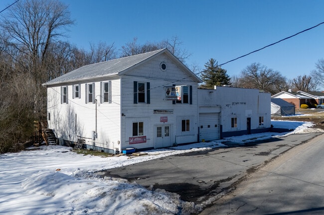
164 Orchard Dr, Timberville, VA 22853


This Property Is For Sale
NEARBY LISTINGS FOR SALE OR LEASE
Property Detail
164 Orchard Dr
Harrisonburg, VA
Smith
40A1-20-L1
SMITH SBDV S 1 L 1
Storebuilding
Rockingham
X
Virginia
51165C0169D
1
2025
0.49 AC
2025
Staunton & Harrisonburg
010900
Other Market Areas
10,356 SF
DEMOGRAPHICS near 164 Orchard Dr
1 Mile
3 Mile
5 Mile
2024 Total Population
2,287
7,728
12,213
2029 Population
2,325
7,885
12,476
Pop Growth 2024-2029
+ 1.66%
+ 2.03%
+ 2.15%
Average Age
42
41
42
2024 Total Households
881
3,038
4,802
HH Growth 2024-2029
+ 1.70%
+ 2.04%
+ 2.14%
Median Household Inc
$65,325
$68,828
$70,165
Avg Household Size
2.50
2.50
2.50
2024 Avg HH Vehicles
2.00
2.00
2.00
Median Home Value
$192,560
$197,261
$207,731
Median Year Built
1975
1980
1981
Nearby Places
Map Layers
Map Styles
 Street
 Aerial
- Restaurants
- Banks
- Shops
- Fitness
- Groceries
Nearby Properties
Address
Land Use
TOTAL SIZE
Lot Size
Zoning
Address
Land Use
TOTAL SIZE
Lot Size
Zoning
225,000 SF
53.75 AC
R1
Address
Land Use
TOTAL SIZE
Lot Size
Zoning
204,203 SF
25 AC
R3
Address
Land Use
TOTAL SIZE
Lot Size
Zoning
61.33 AC
I1
Address
Land Use
TOTAL SIZE
Lot Size
Zoning
127,784 SF
14.84 AC
B1
Address
Land Use
TOTAL SIZE
Lot Size
Zoning
71,905 SF
20 AC
R5
Address
Land Use
TOTAL SIZE
Lot Size
Zoning
1,800 SF
187.24 AC
S1
Address
Land Use
TOTAL SIZE
Lot Size
Zoning
99,168 SF
20 AC
R3
Address
Land Use
TOTAL SIZE
Lot Size
Zoning
98,056 SF
8.67 AC
B1
Address
Land Use
TOTAL SIZE
Lot Size
Zoning
1.97 AC
I1
Address
Land Use
TOTAL SIZE
Lot Size
Zoning
28,412 SF
8.02 AC
R5
Address
Land Use
TOTAL SIZE
Lot Size
Zoning
1,459 SF
6.29 AC
A2
Address
Land Use
TOTAL SIZE
Lot Size
Zoning
7,926 SF
4 AC
R3
Address
Land Use
TOTAL SIZE
Lot Size
Zoning
26,198 SF
1.24 AC
B1
Address
Land Use
TOTAL SIZE
Lot Size
Zoning
38,382 SF
1.69 AC
R3
Address
Land Use
TOTAL SIZE
Lot Size
Zoning
60,170 SF
2.42 AC
B1
Address
Land Use
TOTAL SIZE
Lot Size
Zoning
2,166 SF
6.31 AC
R5
Address
Land Use
TOTAL SIZE
Lot Size
Zoning
2,956 SF
1.82 AC
M1
Address
Land Use
TOTAL SIZE
Lot Size
Zoning
21,834 SF
6.95 AC
R1
Address
Land Use
TOTAL SIZE
Lot Size
Zoning
4 AC
R3
Address
Land Use
TOTAL SIZE
Lot Size
Zoning
30,693 SF
0.69 AC
R1
Address
Land Use
TOTAL SIZE
Lot Size
Zoning
43,348 SF
4.49 AC
TOWN
Address
Land Use
TOTAL SIZE
Lot Size
Zoning
7,646 SF
5.88 AC
R5
Address
Land Use
TOTAL SIZE
Lot Size
Zoning
38,622 SF
0.81 AC
R2
Address
Land Use
TOTAL SIZE
Lot Size
Zoning
15,595 SF
1.29 AC
B1
Address
Land Use
TOTAL SIZE
Lot Size
Zoning
11,056 SF
1.14 AC
R1
Address
Land Use
TOTAL SIZE
Lot Size
Zoning
16,640 SF
1.36 AC
TOWN
Address
Land Use
TOTAL SIZE
Lot Size
Zoning
21,471 SF
7.75 AC
R1
Address
Land Use
TOTAL SIZE
Lot Size
Zoning
3,456 SF
2.40 AC
TOWN
Address
Land Use
TOTAL SIZE
Lot Size
Zoning
3,637 SF
4.60 AC
I1
The World's #1 Commercial Real Estate Marketplace
Connect with us
© 2026 CoStar Group
The information above has been obtained from sources believed reliable. While we do not doubt its accuracy we have not verified it and make no guarantee, warranty or representation about it. It is your responsibility to independently confirm its accuracy and completeness. Any projections, opinions, assumptions, or estimates used are for example only and do not represent the current or future performance of the property. The value of this transaction to you depends on tax and other factors which should be evaluated by your tax, financial, and legal advisors. You and your advisors should conduct a careful, independent investigation of the property to determine to your satisfaction the suitability of the property for your needs.