Property Record
164 Wheatland Loop N, Keizer, OR 97303
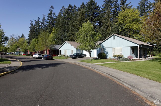

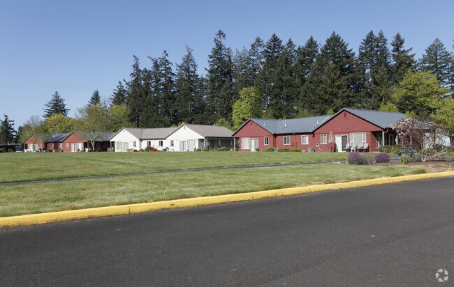
Property Detail
164 Wheatland Loop N
519709
ACRES 4.13
Officebuilding
Marion
RM; EFU
Oregon
2024
4.46 AC
2025
Keizer
002504
Portland
19,498 SF
Salem, OR
NEARBY LISTINGS FOR SALE OR LEASE
-
-
View all Keizer listings for sale on LoopNet.com
DEMOGRAPHICS near 164 Wheatland Loop N
1 mile
3 mile
5 mile
2025 Total Population
6,559
31,840
87,659
2030 Population
6,581
32,016
88,551
Pop Growth 2025-2030
+ 0.34%
+ 0.55%
+ 1.02%
Average Age
40
40
39
2025 Total Households
2,340
11,811
31,328
HH Growth 2025-2030
+ 0.47%
+ 0.66%
+ 1.11%
Median Household Inc
$115,298
$91,199
$71,468
Avg Household Size
2.70
2.60
2.70
2025 Avg HH Vehicles
2.00
2.00
2.00
Median Home Value
$474,758
$445,451
$420,833
Median Year Built
1996
1989
1982
Nearby Places
Map Layers
Map Styles
 Street
 Aerial
Layers
 Traffic
 Biking
Places
Listings with unknown addresses are not visible on the map
- Restaurants
- Banks
- Shops
- Fitness
- Groceries
PUBLIC TRANSPORTATION
COMMUTER RAIL
Salem (Amtrak Cascades - Amtrak, Coast Starlight - Amtrak)
Drive
Walk
Distance
Salem (Amtrak Cascades - Amtrak, Coast Starlight - Amtrak)
18 min
7.9 mi
Freight Ports
Port of Portland
Drive
Walk
Distance
Port of Portland
57 min
43.8 mi
Nearby Properties
Address
Land Use
TOTAL SIZE
Lot Size
Zoning
Address
Land Use
TOTAL SIZE
Lot Size
Zoning
58,868 SF
38.09 AC
P; RM
Address
Land Use
TOTAL SIZE
Lot Size
Zoning
84,940 SF
16.75 AC
IBP
Address
Land Use
TOTAL SIZE
Lot Size
Zoning
68,512 SF
9.09 AC
P
Address
Land Use
TOTAL SIZE
Lot Size
Zoning
161,418 SF
4.48 AC
MU
Address
Land Use
TOTAL SIZE
Lot Size
Zoning
134,440 SF
12.25 AC
IBP
Address
Land Use
TOTAL SIZE
Lot Size
Zoning
150,649 SF
3.67 AC
MU
Address
Land Use
TOTAL SIZE
Lot Size
Zoning
16.15 AC
EFU
Address
Land Use
TOTAL SIZE
Lot Size
Zoning
101,921 SF
3.76 AC
MU
Address
Land Use
TOTAL SIZE
Lot Size
Zoning
123,752 SF
10.14 AC
IBP
Address
Land Use
TOTAL SIZE
Lot Size
Zoning
105,537 SF
5.86 AC
RS
Address
Land Use
TOTAL SIZE
Lot Size
Zoning
54,745 SF
5.32 AC
IBP
Address
Land Use
TOTAL SIZE
Lot Size
Zoning
102,832 SF
4.93 AC
MU
Address
Land Use
TOTAL SIZE
Lot Size
Zoning
93,718 SF
7.23 AC
CM
Address
Land Use
TOTAL SIZE
Lot Size
Zoning
120,177 SF
6.60 AC
MU
Address
Land Use
TOTAL SIZE
Lot Size
Zoning
94,942 SF
4.62 AC
MU
Address
Land Use
TOTAL SIZE
Lot Size
Zoning
Address
Land Use
TOTAL SIZE
Lot Size
Zoning
105,871 SF
5.69 AC
RM-LU
Address
Land Use
TOTAL SIZE
Lot Size
Zoning
94,320 SF
5.08 AC
RM
Address
Land Use
TOTAL SIZE
Lot Size
Zoning
10 SF
18.89 AC
IG
Address
Land Use
TOTAL SIZE
Lot Size
Zoning
111,024 SF
1.52 AC
RM
Address
Land Use
TOTAL SIZE
Lot Size
Zoning
76,063 SF
3.48 AC
MU
Address
Land Use
TOTAL SIZE
Lot Size
Zoning
Address
Land Use
TOTAL SIZE
Lot Size
Zoning
49,549 SF
2.50 AC
IBP
Address
Land Use
TOTAL SIZE
Lot Size
Zoning
31,920 SF
3.09 AC
RM
Address
Land Use
TOTAL SIZE
Lot Size
Zoning
50,607 SF
11.16 AC
IG
Address
Land Use
TOTAL SIZE
Lot Size
Zoning
59,831 SF
2.38 AC
MU
Address
Land Use
TOTAL SIZE
Lot Size
Zoning
80,842 SF
4.57 AC
MU
Address
Land Use
TOTAL SIZE
Lot Size
Zoning
61,440 SF
6.53 AC
RL
Address
Land Use
TOTAL SIZE
Lot Size
Zoning
68,457 SF
3.65 AC
MU; CM
Address
Land Use
TOTAL SIZE
Lot Size
Zoning
27,962 SF
1.82 AC
P
The World's #1 Commercial Real Estate Marketplace
Connect with us
© 2026 CoStar Group
The information above has been obtained from sources believed reliable. While we do not doubt its accuracy we have not verified it and make no guarantee, warranty or representation about it. It is your responsibility to independently confirm its accuracy and completeness. Any projections, opinions, assumptions, or estimates used are for example only and do not represent the current or future performance of the property. The value of this transaction to you depends on tax and other factors which should be evaluated by your tax, financial, and legal advisors. You and your advisors should conduct a careful, independent investigation of the property to determine to your satisfaction the suitability of the property for your needs.