Property Record
1640 142Nd Ave, Dorr, MI 49323

Property Detail
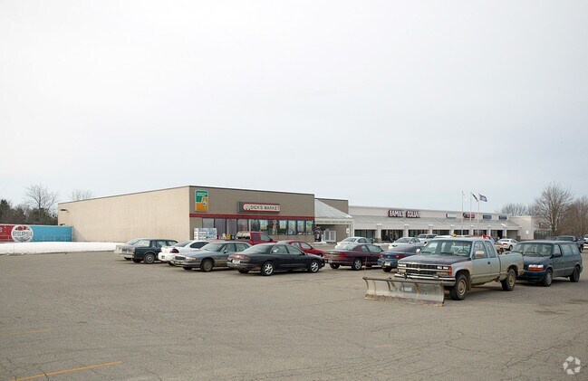
1640 142Nd Ave
05-022-001-10
BEG AT NE COR OF SEC TH S 361' TH W 257' TH S 100' TH W 200' TH S 107.30' TH W 617.84' TH N 20 DEG 51' 53 W 162.81' TH N 416' TH E 1129.80' TO POB EX THE N 276' OF THE E 426.13' THEREOF SEC 22 T4N R12W TAX MAP: 10.13 AC (12).
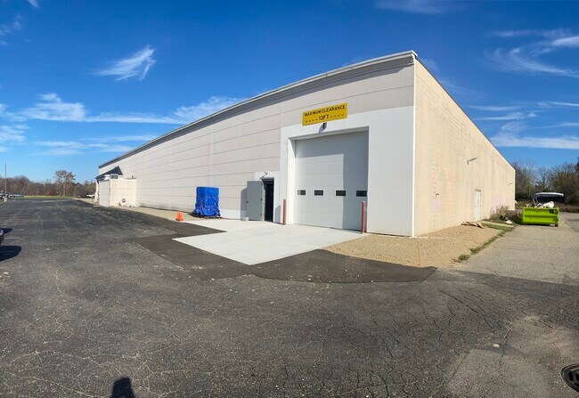
Storebuilding
ALLEGAN
B and X Area of moderate flood hazard, usually the area between the limits of the 100-year and 500-year floods.
Michigan
2024
9.60 AC
2025
Outlying Allegan County
030403
West Michigan
52,071 SF
Holland, MI
NEARBY LISTINGS FOR SALE OR LEASE
-
-
View all Dorr listings for lease on LoopNet.com
DEMOGRAPHICS near 1640 142Nd Ave
1 mile
3 mile
5 mile
2025 Total Population
2,238
8,172
17,579
2030 Population
2,182
8,086
17,646
Pop Growth 2025-2030
(2.50%)
(1.05%)
+ 0.38%
Average Age
39
38
38
2025 Total Households
773
2,763
6,156
HH Growth 2025-2030
(2.59%)
(1.19%)
+ 0.36%
Median Household Inc
$81,849
$88,304
$85,132
Avg Household Size
2.80
2.90
2.80
2025 Avg HH Vehicles
2.00
2.00
2.00
Median Home Value
$248,395
$271,675
$264,015
Median Year Built
1975
1985
1986
Nearby Places
Map Layers
Map Styles
 Street
 Aerial
Layers
 Traffic
 Biking
Places
Listings with unknown addresses are not visible on the map
- Restaurants
- Banks
- Shops
- Fitness
- Groceries
PUBLIC TRANSPORTATION
AIRPORT
Gerald R Ford International
Drive
Walk
Distance
Gerald R Ford International
30 min
20.4 mi
Freight Ports
Port Milwaukee
Drive
Walk
Distance
Port Milwaukee
304 min
261.2 mi
SALE & LEASE HISTORY
LISTING DATE
SALE/LEASE

Sep 25, 2016
For Lease
Nov 09, 2022
For Lease
Nearby Properties
Address
Land Use
TOTAL SIZE
Lot Size
Zoning
Address
Land Use
TOTAL SIZE
Lot Size
Zoning
119.76 AC
Address
Land Use
TOTAL SIZE
Lot Size
Zoning
132,905 SF
58.60 AC
Address
Land Use
TOTAL SIZE
Lot Size
Zoning
54,240 SF
36.50 AC
Address
Land Use
TOTAL SIZE
Lot Size
Zoning
2,351 SF
139 AC
AGRICUL
Address
Land Use
TOTAL SIZE
Lot Size
Zoning
31,890 SF
14 AC
Address
Land Use
TOTAL SIZE
Lot Size
Zoning
32,825 SF
5.05 AC
Address
Land Use
TOTAL SIZE
Lot Size
Zoning
46,060 SF
11.88 AC
Address
Land Use
TOTAL SIZE
Lot Size
Zoning
197.92 AC
Address
Land Use
TOTAL SIZE
Lot Size
Zoning
12,000 SF
6.47 AC
Address
Land Use
TOTAL SIZE
Lot Size
Zoning
7,200 SF
77.64 AC
I INDUS
Address
Land Use
TOTAL SIZE
Lot Size
Zoning
33,164 SF
6.88 AC
Address
Land Use
TOTAL SIZE
Lot Size
Zoning
12,320 SF
4.96 AC
Address
Land Use
TOTAL SIZE
Lot Size
Zoning
16,160 SF
5.48 AC
Address
Land Use
TOTAL SIZE
Lot Size
Zoning
30,600 SF
Address
Land Use
TOTAL SIZE
Lot Size
Zoning
27,540 SF
8.59 AC
Address
Land Use
TOTAL SIZE
Lot Size
Zoning
60.34 AC
Address
Land Use
TOTAL SIZE
Lot Size
Zoning
29,280 SF
5.11 AC
Address
Land Use
TOTAL SIZE
Lot Size
Zoning
120 AC
Address
Land Use
TOTAL SIZE
Lot Size
Zoning
124.93 AC
Address
Land Use
TOTAL SIZE
Lot Size
Zoning
48.34 AC
Address
Land Use
TOTAL SIZE
Lot Size
Zoning
19,800 SF
40.83 AC
Address
Land Use
TOTAL SIZE
Lot Size
Zoning
20,530 SF
2.87 AC
Address
Land Use
TOTAL SIZE
Lot Size
Zoning
1,200 SF
44.70 AC
Address
Land Use
TOTAL SIZE
Lot Size
Zoning
1,901 SF
130 AC
AGRICUL
Address
Land Use
TOTAL SIZE
Lot Size
Zoning
1,538 SF
120 AC
AGRICUL
Address
Land Use
TOTAL SIZE
Lot Size
Zoning
129 AC
Address
Land Use
TOTAL SIZE
Lot Size
Zoning
1,356 SF
60.87 AC
AG
Address
Land Use
TOTAL SIZE
Lot Size
Zoning
1,734 SF
80 AC
AGRICUL
Address
Land Use
TOTAL SIZE
Lot Size
Zoning
3,352 SF
10.87 AC
The World's #1 Commercial Real Estate Marketplace
Connect with us
© 2026 CoStar Group
The information above has been obtained from sources believed reliable. While we do not doubt its accuracy we have not verified it and make no guarantee, warranty or representation about it. It is your responsibility to independently confirm its accuracy and completeness. Any projections, opinions, assumptions, or estimates used are for example only and do not represent the current or future performance of the property. The value of this transaction to you depends on tax and other factors which should be evaluated by your tax, financial, and legal advisors. You and your advisors should conduct a careful, independent investigation of the property to determine to your satisfaction the suitability of the property for your needs.