Property Record
1640 Blair St, Thomasville, NC 27360
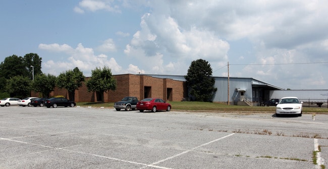

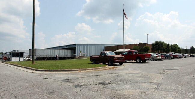
Property Detail
1640 Blair St
16-323-0-000-0075-0-0-0
L75 BK2040-2464 BLAIR ST EXT
Publicstorage
Davidson
M1
North Carolina
C and X Area of minimal flood hazard, usually depicted on FIRMs as above the 500-year flood level.
24.49 AC
2025
North Davidson County
2025
Greensboro/Winston-Salem
061000
Winston-Salem, NC
67,362 SF
NEARBY LISTINGS FOR SALE OR LEASE
DEMOGRAPHICS near 1640 Blair St
1 mile
3 mile
5 mile
2025 Total Population
3,730
31,211
77,137
2030 Population
3,914
32,636
80,466
Pop Growth 2025-2030
+ 4.93%
+ 4.57%
+ 4.32%
Average Age
40
39
40
2025 Total Households
1,484
12,338
30,865
HH Growth 2025-2030
+ 4.99%
+ 4.66%
+ 4.42%
Median Household Inc
$75,060
$60,685
$57,912
Avg Household Size
2.50
2.50
2.40
2025 Avg HH Vehicles
2.00
2.00
2.00
Median Home Value
$170,685
$192,166
$198,468
Median Year Built
1987
1977
1975
Nearby Places
Map Layers
Map Styles
 Street
 Aerial
Layers
 Traffic
 Biking
Places
Listings with unknown addresses are not visible on the map
- Restaurants
- Banks
- Shops
- Fitness
- Groceries
PUBLIC TRANSPORTATION
COMMUTER RAIL
High Point Station (Piedmont - North Carolina by Train (NC Train))
Drive
Walk
Distance
High Point Station (Piedmont - North Carolina by Train (NC Train))
11 min
6.3 mi
AIRPORT
Piedmont Triad International
Drive
Walk
Distance
Piedmont Triad International
34 min
22.0 mi
Nearby Properties
Address
Land Use
TOTAL SIZE
Lot Size
Zoning
Address
Land Use
TOTAL SIZE
Lot Size
Zoning
154,870 SF
62.93 AC
M1
Address
Land Use
TOTAL SIZE
Lot Size
Zoning
104,686 SF
12.97 AC
GB
Address
Land Use
TOTAL SIZE
Lot Size
Zoning
194,644 SF
20 AC
R10
Address
Land Use
TOTAL SIZE
Lot Size
Zoning
351,736 SF
34.77 AC
HI
Address
Land Use
TOTAL SIZE
Lot Size
Zoning
13,770 SF
34.64 AC
R10
Address
Land Use
TOTAL SIZE
Lot Size
Zoning
69,113 SF
7.87 AC
CU-PDM
Address
Land Use
TOTAL SIZE
Lot Size
Zoning
111,312 SF
7.98 AC
RM-26
Address
Land Use
TOTAL SIZE
Lot Size
Zoning
63,936 SF
19.05 AC
R10
Address
Land Use
TOTAL SIZE
Lot Size
Zoning
426,585 SF
27.46 AC
HI
Address
Land Use
TOTAL SIZE
Lot Size
Zoning
51,230 SF
7.52 AC
C2
Address
Land Use
TOTAL SIZE
Lot Size
Zoning
56,305 SF
5.39 AC
OI
Address
Land Use
TOTAL SIZE
Lot Size
Zoning
223,806 SF
12.60 AC
HI
Address
Land Use
TOTAL SIZE
Lot Size
Zoning
82,160 SF
23.62 AC
C2
Address
Land Use
TOTAL SIZE
Lot Size
Zoning
27,310 SF
20.06 AC
HI
Address
Land Use
TOTAL SIZE
Lot Size
Zoning
121,473 SF
32.77 AC
RM-16
Address
Land Use
TOTAL SIZE
Lot Size
Zoning
108,429 SF
14.43 AC
RC
Address
Land Use
TOTAL SIZE
Lot Size
Zoning
57,885 SF
24.14 AC
RA3
Address
Land Use
TOTAL SIZE
Lot Size
Zoning
72,642 SF
10.53 AC
R10
Address
Land Use
TOTAL SIZE
Lot Size
Zoning
124,326 SF
13.45 AC
C3
Address
Land Use
TOTAL SIZE
Lot Size
Zoning
60,183 SF
8.63 AC
C-2
Address
Land Use
TOTAL SIZE
Lot Size
Zoning
127,280 SF
29.10 AC
LI-CZ
Address
Land Use
TOTAL SIZE
Lot Size
Zoning
43,000 SF
15.06 AC
HI
Address
Land Use
TOTAL SIZE
Lot Size
Zoning
234,080 SF
14.88 AC
HI
Address
Land Use
TOTAL SIZE
Lot Size
Zoning
6,960 SF
9.61 AC
R8
Address
Land Use
TOTAL SIZE
Lot Size
Zoning
63,643 SF
8.46 AC
M1
Address
Land Use
TOTAL SIZE
Lot Size
Zoning
38,896 SF
6.64 AC
C2
Address
Land Use
TOTAL SIZE
Lot Size
Zoning
99,649 SF
15.58 AC
HI
Address
Land Use
TOTAL SIZE
Lot Size
Zoning
39,842 SF
12.49 AC
M2
Address
Land Use
TOTAL SIZE
Lot Size
Zoning
35,132 SF
14.36 AC
R10
Address
Land Use
TOTAL SIZE
Lot Size
Zoning
35,582 SF
4.95 AC
R8
The World's #1 Commercial Real Estate Marketplace
Connect with us
© 2026 CoStar Group
The information above has been obtained from sources believed reliable. While we do not doubt its accuracy we have not verified it and make no guarantee, warranty or representation about it. It is your responsibility to independently confirm its accuracy and completeness. Any projections, opinions, assumptions, or estimates used are for example only and do not represent the current or future performance of the property. The value of this transaction to you depends on tax and other factors which should be evaluated by your tax, financial, and legal advisors. You and your advisors should conduct a careful, independent investigation of the property to determine to your satisfaction the suitability of the property for your needs.