Property Record
1640 E Sumner St, Hartford, WI 53027


Save to a Folder
{{folder.Name}}
{{folder.ListingIds.length}} Properties
{{folder.ListingIds.length}} Property
Create a New Folder
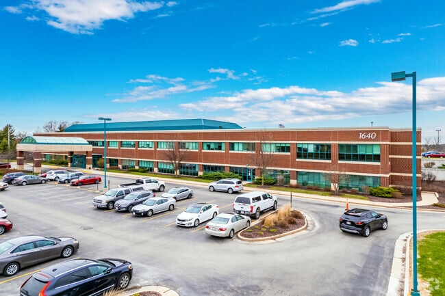
Property Detail
1640 E Sumner St
Milwaukee-Waukesha, WI
PT OF NE CSM 5845 LOT 1 DOC 1312775
36-2201008002
WASHINGTON
Medicalbuilding
Wisconsin
B and X Area of moderate flood hazard, usually the area between the limits of the 100-year and 500-year floods.
1
2025
9.99 AC
2025
Washington West
440105
Milwaukee/Madison
49,735 SF
NEARBY LISTINGS FOR SALE OR LEASE
-
-
View all Hartford listings for sale on LoopNet.com
DEMOGRAPHICS near 1640 E Sumner St
1 mile
3 mile
5 mile
2025 Total Population
3,678
21,169
30,608
2030 Population
3,731
21,584
31,228
Pop Growth 2025-2030
+ 1.44%
+ 1.96%
+ 2.03%
Average Age
45
41
42
2025 Total Households
1,654
8,782
12,453
HH Growth 2025-2030
+ 1.33%
+ 1.84%
+ 1.91%
Median Household Inc
$74,182
$80,939
$90,161
Avg Household Size
2.20
2.40
2.40
2025 Avg HH Vehicles
2.00
2.00
2.00
Median Home Value
$340,576
$311,532
$342,956
Median Year Built
1992
1991
1991
Nearby Places
Map Layers
Map Styles
 Street
 Aerial
Layers
 Traffic
 Biking
Places
Listings with unknown addresses are not visible on the map
- Restaurants
- Banks
- Shops
- Fitness
- Groceries
PUBLIC TRANSPORTATION
AIRPORT
General Mitchell International
Drive
Walk
Distance
General Mitchell International
60 min
42.7 mi
Nearby Properties
Address
Land Use
TOTAL SIZE
Lot Size
Zoning
Address
Land Use
TOTAL SIZE
Lot Size
Zoning
13,314 SF
16.91 AC
Address
Land Use
TOTAL SIZE
Lot Size
Zoning
70,221 SF
7.09 AC
Address
Land Use
TOTAL SIZE
Lot Size
Zoning
94,819 SF
0.18 AC
Address
Land Use
TOTAL SIZE
Lot Size
Zoning
11.63 AC
Address
Land Use
TOTAL SIZE
Lot Size
Zoning
22,814 SF
8.85 AC
Address
Land Use
TOTAL SIZE
Lot Size
Zoning
184,928 SF
22.37 AC
Address
Land Use
TOTAL SIZE
Lot Size
Zoning
16.35 AC
Address
Land Use
TOTAL SIZE
Lot Size
Zoning
15,408 SF
9.39 AC
Address
Land Use
TOTAL SIZE
Lot Size
Zoning
57,888 SF
2.45 AC
Address
Land Use
TOTAL SIZE
Lot Size
Zoning
37,038 SF
1.02 AC
Address
Land Use
TOTAL SIZE
Lot Size
Zoning
5.09 AC
Address
Land Use
TOTAL SIZE
Lot Size
Zoning
8.10 AC
Address
Land Use
TOTAL SIZE
Lot Size
Zoning
6,620 SF
1.26 AC
Address
Land Use
TOTAL SIZE
Lot Size
Zoning
26,340 SF
5.01 AC
Address
Land Use
TOTAL SIZE
Lot Size
Zoning
5.03 AC
Address
Land Use
TOTAL SIZE
Lot Size
Zoning
36,686 SF
1.86 AC
Address
Land Use
TOTAL SIZE
Lot Size
Zoning
55,326 SF
1.37 AC
Address
Land Use
TOTAL SIZE
Lot Size
Zoning
14,276 SF
9.02 AC
Address
Land Use
TOTAL SIZE
Lot Size
Zoning
14,015 SF
2.50 AC
Address
Land Use
TOTAL SIZE
Lot Size
Zoning
15,408 SF
5.25 AC
Address
Land Use
TOTAL SIZE
Lot Size
Zoning
63,705 SF
6.85 AC
Address
Land Use
TOTAL SIZE
Lot Size
Zoning
7.96 AC
Address
Land Use
TOTAL SIZE
Lot Size
Zoning
28,326 SF
3.27 AC
Address
Land Use
TOTAL SIZE
Lot Size
Zoning
7.30 AC
Address
Land Use
TOTAL SIZE
Lot Size
Zoning
Address
Land Use
TOTAL SIZE
Lot Size
Zoning
8.28 AC
Address
Land Use
TOTAL SIZE
Lot Size
Zoning
6,334 SF
2.86 AC
Address
Land Use
TOTAL SIZE
Lot Size
Zoning
184,483 SF
13.89 AC
Address
Land Use
TOTAL SIZE
Lot Size
Zoning
10,870 SF
2.99 AC
The World's #1 Commercial Real Estate Marketplace
Connect with us
© 2026 CoStar Group
The information above has been obtained from sources believed reliable. While we do not doubt its accuracy we have not verified it and make no guarantee, warranty or representation about it. It is your responsibility to independently confirm its accuracy and completeness. Any projections, opinions, assumptions, or estimates used are for example only and do not represent the current or future performance of the property. The value of this transaction to you depends on tax and other factors which should be evaluated by your tax, financial, and legal advisors. You and your advisors should conduct a careful, independent investigation of the property to determine to your satisfaction the suitability of the property for your needs.