Property Record
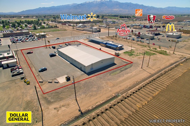
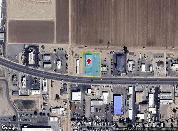
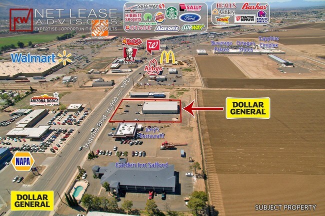
1640 W Thatcher Blvd, Safford, AZ 85546
NEARBY LISTINGS FOR SALE OR LEASE
Property Detail
1640 W Thatcher Blvd
Safford, AZ
Curtis Subdivision
102-15-035B
BEG NE COR LOT 3 CURTIS SUBDIVISION NORTH TH S0D41W ALONG THE DIVIDING LINE OF LOT 3 AND 4 A DISTANCE OF 270.77 TO A POINT ON THE NLY R/W OF STATE HWY 70 TH N87D1116W ALONG SAID R/W 200.23 TO A POINT ON THE DIVIDING LINE OF LOT 1 AND 2 OF SAID SUBDIV
Departmentstore
Graham
X
Arizona
04009C1503D
3
2024
1.24 AC
2026
Arizona SE & Sierra Vista Area
961700
Other Market Areas
8,995 SF
DEMOGRAPHICS near 1640 W Thatcher Blvd
1 Mile
3 Mile
5 Mile
2024 Total Population
3,038
19,800
23,526
2029 Population
3,274
21,276
25,294
Pop Growth 2024-2029
+ 7.77%
+ 7.45%
+ 7.52%
Average Age
39
36
37
2024 Total Households
1,214
7,081
8,398
HH Growth 2024-2029
+ 7.74%
+ 7.46%
+ 7.53%
Median Household Inc
$52,943
$60,074
$60,308
Avg Household Size
2.50
2.70
2.80
2024 Avg HH Vehicles
2.00
2.00
2.00
Median Home Value
$156,456
$182,416
$181,095
Median Year Built
1989
1989
1989
Nearby Places
Map Layers
Map Styles
 Street
 Aerial
- Restaurants
- Banks
- Shops
- Fitness
- Groceries
SALE & LEASE HISTORY
LISTING DATE
SALE/LEASE

Mar 30, 2017
For Sale
Nearby Properties
Address
Land Use
TOTAL SIZE
Lot Size
Zoning
Address
Land Use
TOTAL SIZE
Lot Size
Zoning
58,561 SF
11.75 AC
Address
Land Use
TOTAL SIZE
Lot Size
Zoning
207,922 SF
21.39 AC
Address
Land Use
TOTAL SIZE
Lot Size
Zoning
108,180 SF
47.47 AC
Address
Land Use
TOTAL SIZE
Lot Size
Zoning
95,920 SF
12.23 AC
Address
Land Use
TOTAL SIZE
Lot Size
Zoning
33,539 SF
22.26 AC
Address
Land Use
TOTAL SIZE
Lot Size
Zoning
94,361 SF
10.65 AC
Address
Land Use
TOTAL SIZE
Lot Size
Zoning
65,939 SF
4.97 AC
Address
Land Use
TOTAL SIZE
Lot Size
Zoning
128,419 SF
7.43 AC
Address
Land Use
TOTAL SIZE
Lot Size
Zoning
49,283 SF
20.35 AC
Address
Land Use
TOTAL SIZE
Lot Size
Zoning
48,494 SF
11.13 AC
Address
Land Use
TOTAL SIZE
Lot Size
Zoning
56,564 SF
5.27 AC
Address
Land Use
TOTAL SIZE
Lot Size
Zoning
17,725 SF
8.70 AC
Address
Land Use
TOTAL SIZE
Lot Size
Zoning
49,585 SF
4.95 AC
Address
Land Use
TOTAL SIZE
Lot Size
Zoning
64,022 SF
3.43 AC
Address
Land Use
TOTAL SIZE
Lot Size
Zoning
48,819 SF
3.37 AC
Address
Land Use
TOTAL SIZE
Lot Size
Zoning
43,932 SF
2.26 AC
Address
Land Use
TOTAL SIZE
Lot Size
Zoning
22,912 SF
2.87 AC
Address
Land Use
TOTAL SIZE
Lot Size
Zoning
42,672 SF
7.56 AC
Address
Land Use
TOTAL SIZE
Lot Size
Zoning
104,895 SF
7.94 AC
Address
Land Use
TOTAL SIZE
Lot Size
Zoning
31,613 SF
1.59 AC
Address
Land Use
TOTAL SIZE
Lot Size
Zoning
18,687 SF
0.17 AC
Address
Land Use
TOTAL SIZE
Lot Size
Zoning
105,487 SF
4.75 AC
Address
Land Use
TOTAL SIZE
Lot Size
Zoning
59,698 SF
6.02 AC
Address
Land Use
TOTAL SIZE
Lot Size
Zoning
45,764 SF
3.03 AC
Address
Land Use
TOTAL SIZE
Lot Size
Zoning
36,448 SF
4.52 AC
Address
Land Use
TOTAL SIZE
Lot Size
Zoning
27,946 SF
0.75 AC
Address
Land Use
TOTAL SIZE
Lot Size
Zoning
44,150 SF
2.23 AC
Address
Land Use
TOTAL SIZE
Lot Size
Zoning
20,978 SF
3.42 AC
Address
Land Use
TOTAL SIZE
Lot Size
Zoning
59,281 SF
8.89 AC
Address
Land Use
TOTAL SIZE
Lot Size
Zoning
105,798 SF
4.64 AC
The World's #1 Commercial Real Estate Marketplace
Connect with us
© 2025 CoStar Group
The information above has been obtained from sources believed reliable. While we do not doubt its accuracy we have not verified it and make no guarantee, warranty or representation about it. It is your responsibility to independently confirm its accuracy and completeness. Any projections, opinions, assumptions, or estimates used are for example only and do not represent the current or future performance of the property. The value of this transaction to you depends on tax and other factors which should be evaluated by your tax, financial, and legal advisors. You and your advisors should conduct a careful, independent investigation of the property to determine to your satisfaction the suitability of the property for your needs.