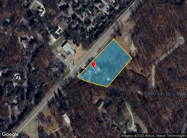
Property Record
16409 Red Arrow Hwy, Union Pier, MI 49129
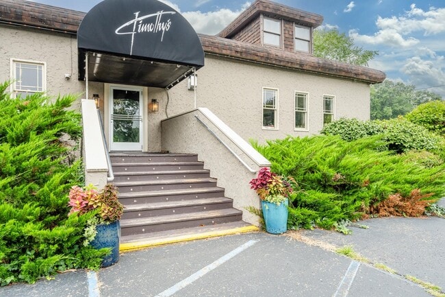
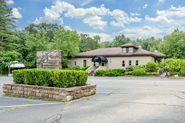
This Property Is For Sale
NEARBY LISTINGS FOR SALE OR LEASE
Property Detail
16409 Red Arrow Hwy
11-13-0336-0066-04-0
SPLIT/COMBINED ON 01/05/2017 FROM 13-0336-0066-03-9, 13-0336-0073-10-8; COM AT CEN SEC 36 T7S R21W TH W 172' TO C/L OF COMMUNITY HALL RD TH N78DEG10'W ON SD C/L 331.6' TO POB TH N78DEG10'W 163.4' TH N64DEG30'W 95.8' TH N40DEG50'W ALL ON SD C/L 20.5'
Restaurantbuilding
Berrien
X
Michigan
26021C0330D
20-331
2024
2.51 AC
2025
Michigan Southwest Area
011301
Other Market Areas
6,847 SF
Niles-Benton Harbor, MI
DEMOGRAPHICS near 16409 Red Arrow Hwy
1 Mile
3 Mile
5 Mile
2024 Total Population
1,075
3,801
9,645
2029 Population
1,175
4,122
10,306
Pop Growth 2024-2029
+ 9.30%
+ 8.45%
+ 6.85%
Average Age
51
51
50
2024 Total Households
522
1,868
4,571
HH Growth 2024-2029
+ 9.20%
+ 8.46%
+ 7.04%
Median Household Inc
$86,218
$80,246
$75,134
Avg Household Size
2.10
2.00
2.10
2024 Avg HH Vehicles
2.00
2.00
2.00
Median Home Value
$587,078
$535,473
$436,511
Median Year Built
1983
1975
1971
Nearby Places
- Restaurants
- Banks
- Shops
- Fitness
- Groceries
PUBLIC TRANSPORTATION
COMMUTER RAIL
New Buffalo Amtrak (Blue Water - Amtrak, Wolverine - Amtrak)
DRIVE
WALK
Distance
New Buffalo Amtrak (Blue Water - Amtrak, Wolverine - Amtrak)
6 min
3.4 mi
AIRPORT
South Bend International
DRIVE
WALK
Distance
South Bend International
55 min
33.1 mi
Freight Ports
Port Milwaukee
DRIVE
WALK
Distance
Port Milwaukee
193 min
157.7 mi
Nearby Properties
Address
Land Use
TOTAL SIZE
Lot Size
Zoning
Address
Land Use
TOTAL SIZE
Lot Size
Zoning
14,542 SF
4.10 AC
R-1
Address
Land Use
TOTAL SIZE
Lot Size
Zoning
162 SF
161.16 AC
Address
Land Use
TOTAL SIZE
Lot Size
Zoning
4,660 SF
49.10 AC
Address
Land Use
TOTAL SIZE
Lot Size
Zoning
8,998 SF
2.73 AC
GCD
Address
Land Use
TOTAL SIZE
Lot Size
Zoning
7,632 SF
1.07 AC
R-1
Address
Land Use
TOTAL SIZE
Lot Size
Zoning
14,642 SF
0.30 AC
CBD
Address
Land Use
TOTAL SIZE
Lot Size
Zoning
86.91 AC
Address
Land Use
TOTAL SIZE
Lot Size
Zoning
0.74 AC
R-1
Address
Land Use
TOTAL SIZE
Lot Size
Zoning
0.57 AC
R-1
Address
Land Use
TOTAL SIZE
Lot Size
Zoning
0.57 AC
R-1
Address
Land Use
TOTAL SIZE
Lot Size
Zoning
0.57 AC
R-1
Address
Land Use
TOTAL SIZE
Lot Size
Zoning
0.84 AC
Address
Land Use
TOTAL SIZE
Lot Size
Zoning
1.27 AC
Address
Land Use
TOTAL SIZE
Lot Size
Zoning
15,198 SF
0.80 AC
CBD
Address
Land Use
TOTAL SIZE
Lot Size
Zoning
0.72 AC
Address
Land Use
TOTAL SIZE
Lot Size
Zoning
2,791 SF
62.43 AC
Address
Land Use
TOTAL SIZE
Lot Size
Zoning
21,854 SF
0.70 AC
CBD
Address
Land Use
TOTAL SIZE
Lot Size
Zoning
60,475 SF
Address
Land Use
TOTAL SIZE
Lot Size
Zoning
7,910 SF
0.41 AC
CBD
Address
Land Use
TOTAL SIZE
Lot Size
Zoning
2.76 AC
R-1
Address
Land Use
TOTAL SIZE
Lot Size
Zoning
3,721 SF
2.50 AC
GCD
Address
Land Use
TOTAL SIZE
Lot Size
Zoning
0.74 AC
R-1
Address
Land Use
TOTAL SIZE
Lot Size
Zoning
1.70 AC
R-1
Address
Land Use
TOTAL SIZE
Lot Size
Zoning
3.95 AC
Address
Land Use
TOTAL SIZE
Lot Size
Zoning
0.67 AC
SELECTZONI
Address
Land Use
TOTAL SIZE
Lot Size
Zoning
0.56 AC
SELECTZONI
Address
Land Use
TOTAL SIZE
Lot Size
Zoning
0.49 AC
R-1
Address
Land Use
TOTAL SIZE
Lot Size
Zoning
0.41 AC
R-1
Address
Land Use
TOTAL SIZE
Lot Size
Zoning
0.40 AC
R-1
Address
Land Use
TOTAL SIZE
Lot Size
Zoning
0.45 AC
R-1
The World's #1 Commercial Real Estate Marketplace
Connect with us
© 2025 CoStar Group
The information above has been obtained from sources believed reliable. While we do not doubt its accuracy we have not verified it and make no guarantee, warranty or representation about it. It is your responsibility to independently confirm its accuracy and completeness. Any projections, opinions, assumptions, or estimates used are for example only and do not represent the current or future performance of the property. The value of this transaction to you depends on tax and other factors which should be evaluated by your tax, financial, and legal advisors. You and your advisors should conduct a careful, independent investigation of the property to determine to your satisfaction the suitability of the property for your needs.