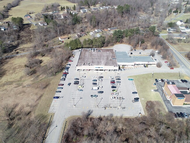
Property Record
1641 Blue Ridge Blvd, Troutville, VA 24175


NEARBY LISTINGS FOR SALE OR LEASE
-
-
View all Troutville listings for lease on LoopNet.com
Property Detail
1641 Blue Ridge Blvd
108-101
GLADE CR
Commercialnec
Botetourt
A
Virginia
51023C0480C
12.87 AC
2024
Botetourt County
2025
Roanoke
040501
Roanoke, VA
DEMOGRAPHICS near 1641 Blue Ridge Blvd
1 Mile
3 Mile
5 Mile
2024 Total Population
1,759
11,753
32,945
2029 Population
1,813
12,030
33,327
Pop Growth 2024-2029
+ 3.07%
+ 2.36%
+ 1.16%
Average Age
44
44
43
2024 Total Households
680
4,647
13,345
HH Growth 2024-2029
+ 2.94%
+ 2.26%
+ 1.04%
Median Household Inc
$83,027
$85,338
$78,006
Avg Household Size
2.60
2.50
2.40
2024 Avg HH Vehicles
2.00
2.00
2.00
Median Home Value
$274,358
$278,588
$256,314
Median Year Built
1984
1989
1984
Nearby Places
Map Layers
Map Styles
 Street
 Aerial
- Restaurants
- Banks
- Shops
- Fitness
- Groceries
PUBLIC TRANSPORTATION
COMMUTER RAIL
Roanoke (Northeast Regional - Amtrak)
DRIVE
WALK
Distance
Roanoke (Northeast Regional - Amtrak)
16 min
8.2 mi
AIRPORT
Roanoke/Blacksburg Regional (Woodrum Field)
DRIVE
WALK
Distance
Roanoke/Blacksburg Regional (Woodrum Field)
22 min
11.3 mi
Freight Ports
Virginia Port Authority - Richmond
DRIVE
WALK
Distance
Virginia Port Authority - Richmond
205 min
154.1 mi
SALE & LEASE HISTORY
LISTING DATE
SALE/LEASE

Oct 14, 2022
For Lease
Mar 08, 2017
For Lease
Jul 08, 2025
For Lease
Dec 10, 2021
For Sale
Aug 11, 2020
For Sale
Nearby Properties
Address
Land Use
TOTAL SIZE
Lot Size
Zoning
Address
Land Use
TOTAL SIZE
Lot Size
Zoning
1,991 SF
26.77 AC
R-1
Address
Land Use
TOTAL SIZE
Lot Size
Zoning
24,126 SF
20.11 AC
R3
Address
Land Use
TOTAL SIZE
Lot Size
Zoning
40.12 AC
M-1
Address
Land Use
TOTAL SIZE
Lot Size
Zoning
57,985 SF
12.66 AC
R1
Address
Land Use
TOTAL SIZE
Lot Size
Zoning
391,945 SF
25 AC
I1C
Address
Land Use
TOTAL SIZE
Lot Size
Zoning
183,960 SF
27.63 AC
C2
Address
Land Use
TOTAL SIZE
Lot Size
Zoning
69,212 SF
19.65 AC
R3S
Address
Land Use
TOTAL SIZE
Lot Size
Zoning
134,019 SF
14.84 AC
C2
Address
Land Use
TOTAL SIZE
Lot Size
Zoning
83,159 SF
15.49 AC
C2S
Address
Land Use
TOTAL SIZE
Lot Size
Zoning
9.14 AC
M-2
Address
Land Use
TOTAL SIZE
Lot Size
Zoning
4 AC
B-2
Address
Land Use
TOTAL SIZE
Lot Size
Zoning
28,326 SF
13.05 AC
C1
Address
Land Use
TOTAL SIZE
Lot Size
Zoning
8.50 AC
A1
Address
Land Use
TOTAL SIZE
Lot Size
Zoning
4.78 AC
R-1
Address
Land Use
TOTAL SIZE
Lot Size
Zoning
13.39 AC
M-2
Address
Land Use
TOTAL SIZE
Lot Size
Zoning
75,080 SF
16.96 AC
M-2
Address
Land Use
TOTAL SIZE
Lot Size
Zoning
4,600 SF
83.17 AC
4
Address
Land Use
TOTAL SIZE
Lot Size
Zoning
26,386 SF
4.28 AC
R2
Address
Land Use
TOTAL SIZE
Lot Size
Zoning
1,080 SF
1.11 AC
B-2
Address
Land Use
TOTAL SIZE
Lot Size
Zoning
6.66 AC
M-1
Address
Land Use
TOTAL SIZE
Lot Size
Zoning
13.50 AC
M-2
Address
Land Use
TOTAL SIZE
Lot Size
Zoning
9.95 AC
A1
Address
Land Use
TOTAL SIZE
Lot Size
Zoning
11,348 SF
5.28 AC
C1
Address
Land Use
TOTAL SIZE
Lot Size
Zoning
30.08 AC
1
Address
Land Use
TOTAL SIZE
Lot Size
Zoning
3.24 AC
B-1
Address
Land Use
TOTAL SIZE
Lot Size
Zoning
5,046 SF
1.44 AC
C2
Address
Land Use
TOTAL SIZE
Lot Size
Zoning
1.96 AC
B-2
Address
Land Use
TOTAL SIZE
Lot Size
Zoning
1.54 AC
B-2
Address
Land Use
TOTAL SIZE
Lot Size
Zoning
0.80 AC
B-2
The World's #1 Commercial Real Estate Marketplace
Connect with us
© 2025 CoStar Group
The information above has been obtained from sources believed reliable. While we do not doubt its accuracy we have not verified it and make no guarantee, warranty or representation about it. It is your responsibility to independently confirm its accuracy and completeness. Any projections, opinions, assumptions, or estimates used are for example only and do not represent the current or future performance of the property. The value of this transaction to you depends on tax and other factors which should be evaluated by your tax, financial, and legal advisors. You and your advisors should conduct a careful, independent investigation of the property to determine to your satisfaction the suitability of the property for your needs.