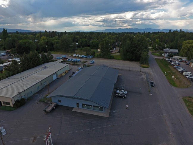
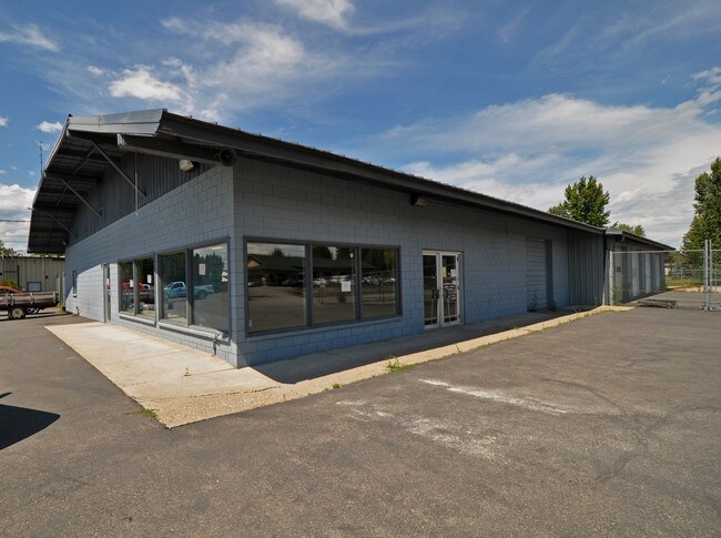
Property Record
1641 Mt Highway 35, Kalispell, MT 59901

NEARBY LISTINGS FOR SALE OR LEASE
Property Detail
1641 Mt Highway 35
Kalispell, MT
Bernards Park Amd L19&20 Blk 2
07-3966-03-2-11-10-0000
BERNARDS PARKAMD L19&20 B2, S03, T28 N, R21 W, LOT 020
Commercialbuilding
Flathead
AE
Montana
30029C1810J
20
2025
0.81 AC
2025
Glacier Country
000700
Other Market Areas
8,520 SF
DEMOGRAPHICS near 1641 Mt Highway 35
1 Mile
3 Mile
5 Mile
2024 Total Population
5,366
21,930
49,987
2029 Population
6,317
25,794
58,997
Pop Growth 2024-2029
+ 17.72%
+ 17.62%
+ 18.02%
Average Age
39
42
40
2024 Total Households
2,097
8,877
20,165
HH Growth 2024-2029
+ 17.50%
+ 17.51%
+ 17.93%
Median Household Inc
$66,004
$66,550
$65,435
Avg Household Size
2.50
2.30
2.40
2024 Avg HH Vehicles
2.00
2.00
2.00
Median Home Value
$247,967
$353,843
$362,110
Median Year Built
1979
1985
1991
Nearby Places
Map Layers
Map Styles
 Street
 Aerial
- Restaurants
- Banks
- Shops
- Fitness
- Groceries
PUBLIC TRANSPORTATION
AIRPORT
Glacier Park International
DRIVE
WALK
Distance
Glacier Park International
13 min
7.7 mi
Freight Ports
Port of Everett
DRIVE
WALK
Distance
Port of Everett
631 min
547.5 mi
SALE & LEASE HISTORY
LISTING DATE
SALE/LEASE

Sep 24, 2016
For Sale
Nearby Properties
Address
Land Use
TOTAL SIZE
Lot Size
Zoning
Address
Land Use
TOTAL SIZE
Lot Size
Zoning
800,000 SF
9.86 AC
5
Address
Land Use
TOTAL SIZE
Lot Size
Zoning
85,209 SF
3.32 AC
Address
Land Use
TOTAL SIZE
Lot Size
Zoning
57,624 SF
3.73 AC
Address
Land Use
TOTAL SIZE
Lot Size
Zoning
58,248 SF
11.94 AC
5
Address
Land Use
TOTAL SIZE
Lot Size
Zoning
188,028 SF
17.70 AC
Address
Land Use
TOTAL SIZE
Lot Size
Zoning
79,844 SF
3.21 AC
Address
Land Use
TOTAL SIZE
Lot Size
Zoning
45,000 SF
6.79 AC
Address
Land Use
TOTAL SIZE
Lot Size
Zoning
231,514 SF
22.45 AC
6
Address
Land Use
TOTAL SIZE
Lot Size
Zoning
31,230 SF
0.64 AC
Address
Land Use
TOTAL SIZE
Lot Size
Zoning
59,195 SF
5 AC
Address
Land Use
TOTAL SIZE
Lot Size
Zoning
32,769 SF
Address
Land Use
TOTAL SIZE
Lot Size
Zoning
57,840 SF
30.18 AC
Address
Land Use
TOTAL SIZE
Lot Size
Zoning
69,429 SF
5.97 AC
Address
Land Use
TOTAL SIZE
Lot Size
Zoning
58,563 SF
4.38 AC
Address
Land Use
TOTAL SIZE
Lot Size
Zoning
129,708 SF
14.69 AC
Address
Land Use
TOTAL SIZE
Lot Size
Zoning
103,353 SF
8.23 AC
1
Address
Land Use
TOTAL SIZE
Lot Size
Zoning
52,653 SF
1.72 AC
Address
Land Use
TOTAL SIZE
Lot Size
Zoning
20,711 SF
2.33 AC
5
Address
Land Use
TOTAL SIZE
Lot Size
Zoning
50,622 SF
5.49 AC
1
Address
Land Use
TOTAL SIZE
Lot Size
Zoning
16,000 SF
6.30 AC
Address
Land Use
TOTAL SIZE
Lot Size
Zoning
37,471 SF
5.41 AC
Address
Land Use
TOTAL SIZE
Lot Size
Zoning
36,576 SF
2 AC
Address
Land Use
TOTAL SIZE
Lot Size
Zoning
35,574 SF
2.98 AC
Address
Land Use
TOTAL SIZE
Lot Size
Zoning
53,199 SF
0.96 AC
6
Address
Land Use
TOTAL SIZE
Lot Size
Zoning
18,944 SF
3.52 AC
Address
Land Use
TOTAL SIZE
Lot Size
Zoning
19,874 SF
3.65 AC
5
Address
Land Use
TOTAL SIZE
Lot Size
Zoning
2,621 SF
55.53 AC
Address
Land Use
TOTAL SIZE
Lot Size
Zoning
33,322 SF
2.79 AC
Address
Land Use
TOTAL SIZE
Lot Size
Zoning
21.95 AC
3
Address
Land Use
TOTAL SIZE
Lot Size
Zoning
31,680 SF
2.23 AC
1
The World's #1 Commercial Real Estate Marketplace
Connect with us
© 2025 CoStar Group
The information above has been obtained from sources believed reliable. While we do not doubt its accuracy we have not verified it and make no guarantee, warranty or representation about it. It is your responsibility to independently confirm its accuracy and completeness. Any projections, opinions, assumptions, or estimates used are for example only and do not represent the current or future performance of the property. The value of this transaction to you depends on tax and other factors which should be evaluated by your tax, financial, and legal advisors. You and your advisors should conduct a careful, independent investigation of the property to determine to your satisfaction the suitability of the property for your needs.