Property Record
1642 E Main St, Center Conway, NH 03813

Property Detail
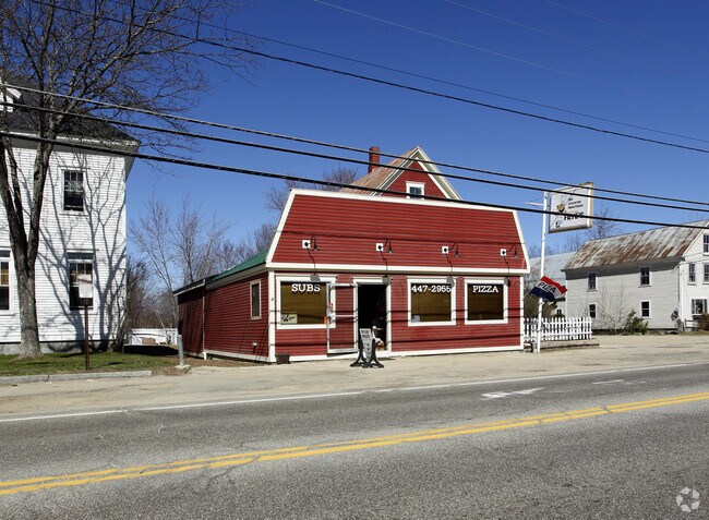
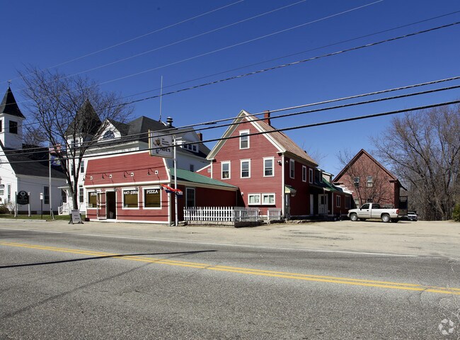
1642 E Main St
Restaurantbuilding
CARROLL
VC
New Hampshire
B and X Area of moderate flood hazard, usually the area between the limits of the 100-year and 500-year floods.
1.30 AC
2025
Concord/New Hampshire North Area
2025
Other Market Areas
955301
CNWY-000260-000000-000002
NEARBY LISTINGS FOR SALE OR LEASE
-
-
View all Center Conway listings for sale on LoopNet.com
DEMOGRAPHICS near 1642 E Main St
1 mile
3 mile
5 mile
2025 Total Population
243
3,563
8,735
2030 Population
233
3,465
8,640
Pop Growth 2025-2030
(4.12%)
(2.75%)
(1.09%)
Average Age
47
48
47
2025 Total Households
106
1,641
3,984
HH Growth 2025-2030
(3.77%)
(2.86%)
(1.23%)
Median Household Inc
$55,624
$53,650
$64,260
Avg Household Size
2.20
2.10
2.10
2025 Avg HH Vehicles
2.00
2.00
2.00
Median Home Value
$311,538
$300,543
$314,490
Median Year Built
1984
1984
1979
Nearby Places
Map Layers
Map Styles
 Street
 Aerial
Layers
 Traffic
 Biking
Places
Listings with unknown addresses are not visible on the map
- Restaurants
- Banks
- Shops
- Fitness
- Groceries
Nearby Properties
Address
Land Use
TOTAL SIZE
Lot Size
Zoning
Address
Land Use
TOTAL SIZE
Lot Size
Zoning
31.40 AC
HC
Address
Land Use
TOTAL SIZE
Lot Size
Zoning
64.60 AC
RA
Address
Land Use
TOTAL SIZE
Lot Size
Zoning
18.25 AC
HC
Address
Land Use
TOTAL SIZE
Lot Size
Zoning
190 AC
HC
Address
Land Use
TOTAL SIZE
Lot Size
Zoning
8.06 AC
HC
Address
Land Use
TOTAL SIZE
Lot Size
Zoning
75.47 AC
RA
Address
Land Use
TOTAL SIZE
Lot Size
Zoning
6.36 AC
HC
Address
Land Use
TOTAL SIZE
Lot Size
Zoning
73.70 AC
RA
Address
Land Use
TOTAL SIZE
Lot Size
Zoning
4.50 AC
HC
Address
Land Use
TOTAL SIZE
Lot Size
Zoning
4.20 AC
HC
Address
Land Use
TOTAL SIZE
Lot Size
Zoning
75 AC
SHR-SH
Address
Land Use
TOTAL SIZE
Lot Size
Zoning
18.96 AC
HC
Address
Land Use
TOTAL SIZE
Lot Size
Zoning
10.30 AC
SHR-SH
Address
Land Use
TOTAL SIZE
Lot Size
Zoning
15.79 AC
VR
Address
Land Use
TOTAL SIZE
Lot Size
Zoning
6.47 AC
HC
Address
Land Use
TOTAL SIZE
Lot Size
Zoning
Address
Land Use
TOTAL SIZE
Lot Size
Zoning
Address
Land Use
TOTAL SIZE
Lot Size
Zoning
2.99 AC
HC
Address
Land Use
TOTAL SIZE
Lot Size
Zoning
3.95 AC
RA
Address
Land Use
TOTAL SIZE
Lot Size
Zoning
36 AC
HC
Address
Land Use
TOTAL SIZE
Lot Size
Zoning
8.08 AC
IN
Address
Land Use
TOTAL SIZE
Lot Size
Zoning
1,883 SF
2.80 AC
RA
Address
Land Use
TOTAL SIZE
Lot Size
Zoning
1,260 SF
33.45 AC
RA
Address
Land Use
TOTAL SIZE
Lot Size
Zoning
10.36 AC
HC
Address
Land Use
TOTAL SIZE
Lot Size
Zoning
5.32 AC
VC
Address
Land Use
TOTAL SIZE
Lot Size
Zoning
4.10 AC
HC
Address
Land Use
TOTAL SIZE
Lot Size
Zoning
2,758 SF
3.80 AC
RA
Address
Land Use
TOTAL SIZE
Lot Size
Zoning
9.97 AC
HC
Address
Land Use
TOTAL SIZE
Lot Size
Zoning
2.41 AC
HC
Address
Land Use
TOTAL SIZE
Lot Size
Zoning
1,520 SF
4.50 AC
RA
The World's #1 Commercial Real Estate Marketplace
Connect with us
© 2026 CoStar Group
The information above has been obtained from sources believed reliable. While we do not doubt its accuracy we have not verified it and make no guarantee, warranty or representation about it. It is your responsibility to independently confirm its accuracy and completeness. Any projections, opinions, assumptions, or estimates used are for example only and do not represent the current or future performance of the property. The value of this transaction to you depends on tax and other factors which should be evaluated by your tax, financial, and legal advisors. You and your advisors should conduct a careful, independent investigation of the property to determine to your satisfaction the suitability of the property for your needs.