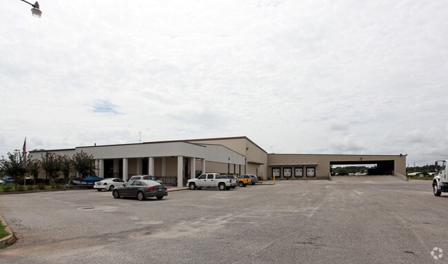
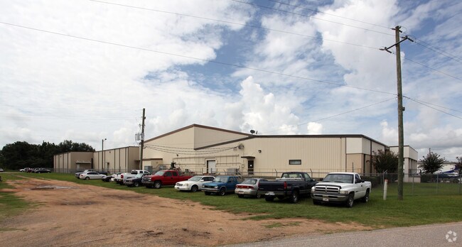
Property Record
16430 Black Devine Rd, Loxley, AL 36551

Property Detail
16430 Black Devine Rd
42-06-14-0-000-003.000
340'S X 665' IRR BEG AT NE COR OF SW1/4 RUN W250' 7 SE 30' TO POB CONT SE510' SE300' NW665' E340' TO POB SEC 14-T5S-R3E(WD)#5
Warehouse
BALDWIN
B and X Area of moderate flood hazard, usually the area between the limits of the 100-year and 500-year floods.
Alabama
2025
4.13 AC
2025
Baldwin County
010903
Mobile
66,295 SF
Daphne-Fairhope-Foley, AL
NEARBY LISTINGS FOR SALE OR LEASE
DEMOGRAPHICS near 16430 Black Devine Rd
1 mile
3 mile
5 mile
2025 Total Population
1,777
8,476
19,585
2030 Population
1,926
9,204
21,292
Pop Growth 2025-2030
+ 8.38%
+ 8.59%
+ 8.72%
Average Age
39
39
39
2025 Total Households
610
2,918
6,948
HH Growth 2025-2030
+ 8.69%
+ 8.81%
+ 8.81%
Median Household Inc
$77,055
$70,692
$67,418
Avg Household Size
2.60
2.70
2.70
2025 Avg HH Vehicles
2.00
2.00
2.00
Median Home Value
$244,651
$246,725
$249,027
Median Year Built
2001
1999
1998
Nearby Places
Map Layers
Map Styles
 Street
 Aerial
Layers
 Traffic
 Biking
Places
Listings with unknown addresses are not visible on the map
- Restaurants
- Banks
- Shops
- Fitness
- Groceries
PUBLIC TRANSPORTATION
AIRPORT
Mobile International
Drive
Walk
Distance
Mobile International
35 min
25.7 mi
Mobile Regional
Drive
Walk
Distance
Mobile Regional
57 min
35.5 mi
Pensacola International
Drive
Walk
Distance
Pensacola International
55 min
43.3 mi
Freight Ports
Port of Mobile
Drive
Walk
Distance
Port of Mobile
29 min
21.8 mi
Nearby Properties
Address
Land Use
TOTAL SIZE
Lot Size
Zoning
Address
Land Use
TOTAL SIZE
Lot Size
Zoning
966 SF
30 AC
Address
Land Use
TOTAL SIZE
Lot Size
Zoning
Address
Land Use
TOTAL SIZE
Lot Size
Zoning
26,040 SF
15 AC
Address
Land Use
TOTAL SIZE
Lot Size
Zoning
Address
Land Use
TOTAL SIZE
Lot Size
Zoning
90,000 SF
15 AC
Address
Land Use
TOTAL SIZE
Lot Size
Zoning
15,000 SF
20 AC
Address
Land Use
TOTAL SIZE
Lot Size
Zoning
39,082 SF
1.67 AC
Address
Land Use
TOTAL SIZE
Lot Size
Zoning
6,148 SF
1.12 AC
Address
Land Use
TOTAL SIZE
Lot Size
Zoning
42,423 SF
2.95 AC
Address
Land Use
TOTAL SIZE
Lot Size
Zoning
24,920 SF
5.10 AC
Address
Land Use
TOTAL SIZE
Lot Size
Zoning
Address
Land Use
TOTAL SIZE
Lot Size
Zoning
17,021 SF
0.81 AC
Address
Land Use
TOTAL SIZE
Lot Size
Zoning
19,066 SF
7.80 AC
Address
Land Use
TOTAL SIZE
Lot Size
Zoning
5,334 SF
2.51 AC
Address
Land Use
TOTAL SIZE
Lot Size
Zoning
10,007 SF
1.14 AC
Address
Land Use
TOTAL SIZE
Lot Size
Zoning
Address
Land Use
TOTAL SIZE
Lot Size
Zoning
870 SF
10 AC
Address
Land Use
TOTAL SIZE
Lot Size
Zoning
12,000 SF
2 AC
Address
Land Use
TOTAL SIZE
Lot Size
Zoning
2,803 SF
3.68 AC
Address
Land Use
TOTAL SIZE
Lot Size
Zoning
8,126 SF
11 AC
Address
Land Use
TOTAL SIZE
Lot Size
Zoning
Address
Land Use
TOTAL SIZE
Lot Size
Zoning
5,600 SF
5.20 AC
Address
Land Use
TOTAL SIZE
Lot Size
Zoning
6,255 SF
1.37 AC
Address
Land Use
TOTAL SIZE
Lot Size
Zoning
7,291 SF
2 AC
Address
Land Use
TOTAL SIZE
Lot Size
Zoning
15,254 SF
9.70 AC
Address
Land Use
TOTAL SIZE
Lot Size
Zoning
2,952 SF
Address
Land Use
TOTAL SIZE
Lot Size
Zoning
2,858 SF
5 AC
Address
Land Use
TOTAL SIZE
Lot Size
Zoning
26,611 SF
1.35 AC
Address
Land Use
TOTAL SIZE
Lot Size
Zoning
3,522 SF
3.15 AC
The World's #1 Commercial Real Estate Marketplace
Connect with us
© 2026 CoStar Group
The information above has been obtained from sources believed reliable. While we do not doubt its accuracy we have not verified it and make no guarantee, warranty or representation about it. It is your responsibility to independently confirm its accuracy and completeness. Any projections, opinions, assumptions, or estimates used are for example only and do not represent the current or future performance of the property. The value of this transaction to you depends on tax and other factors which should be evaluated by your tax, financial, and legal advisors. You and your advisors should conduct a careful, independent investigation of the property to determine to your satisfaction the suitability of the property for your needs.