Property Record
16431 State Road 31, Fort Myers, FL 33905
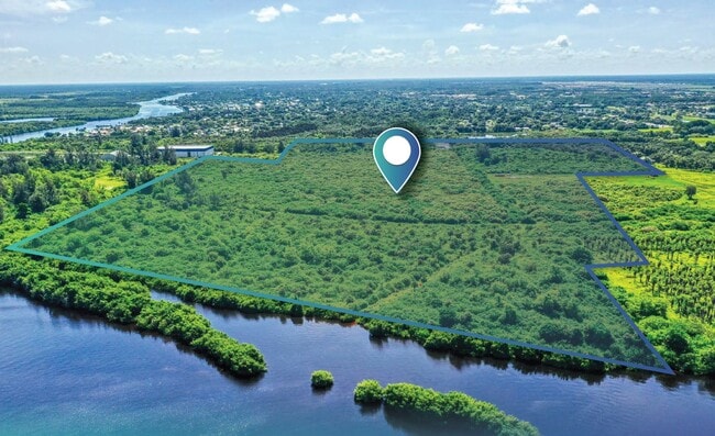


This Property Is For Sale
NEARBY LISTINGS FOR SALE OR LEASE
Property Detail
16431 State Road 31
Cape Coral-Fort Myers, FL
Ft Myers Shores
25-43-25-00-00002.0080
PARL IN N E 1/4 OF S E 1/4 AS DESC IN OR 0627 PG 0165
Residentialacreage
Lee
AE
Florida
12071C0284G
8
2024
8.75 AC
2025
City of Ft Myers
040123
Southwest Florida
DEMOGRAPHICS near 16431 State Road 31
1 Mile
3 Mile
5 Mile
2024 Total Population
2,501
16,775
43,476
2029 Population
2,967
19,950
51,886
Pop Growth 2024-2029
+ 18.63%
+ 18.93%
+ 19.34%
Average Age
49
48
43
2024 Total Households
1,106
7,108
16,526
HH Growth 2024-2029
+ 18.44%
+ 18.78%
+ 19.10%
Median Household Inc
$68,595
$70,377
$69,001
Avg Household Size
2.20
2.30
2.50
2024 Avg HH Vehicles
2.00
2.00
2.00
Median Home Value
$274,906
$280,239
$270,756
Median Year Built
1985
1989
1990
Nearby Places
Map Layers
Map Styles
 Street
 Aerial
- Restaurants
- Banks
- Shops
- Fitness
- Groceries
PUBLIC TRANSPORTATION
AIRPORT
Southwest Florida International
DRIVE
WALK
Distance
Southwest Florida International
23 min
16.2 mi
Punta Gorda
DRIVE
WALK
Distance
Punta Gorda
30 min
23.7 mi
Freight Ports
Port Manatee
DRIVE
WALK
Distance
Port Manatee
110 min
95.4 mi
Nearby Properties
Address
Land Use
TOTAL SIZE
Lot Size
Zoning
Address
Land Use
TOTAL SIZE
Lot Size
Zoning
254,384 SF
42.57 AC
AG-2
Address
Land Use
TOTAL SIZE
Lot Size
Zoning
291,613 SF
40.32 AC
RPD
Address
Land Use
TOTAL SIZE
Lot Size
Zoning
103,525 SF
236.09 AC
IL
Address
Land Use
TOTAL SIZE
Lot Size
Zoning
176,775 SF
98.93 AC
CF-3
Address
Land Use
TOTAL SIZE
Lot Size
Zoning
86,379 SF
9.85 AC
MPD
Address
Land Use
TOTAL SIZE
Lot Size
Zoning
30,708 SF
9.33 AC
CPD
Address
Land Use
TOTAL SIZE
Lot Size
Zoning
51,512 SF
128.26 AC
AG-2
Address
Land Use
TOTAL SIZE
Lot Size
Zoning
77,483 SF
13.37 AC
C2CT
Address
Land Use
TOTAL SIZE
Lot Size
Zoning
30,418 SF
1.48 AC
CPD
Address
Land Use
TOTAL SIZE
Lot Size
Zoning
56,189 SF
5.51 AC
CC
Address
Land Use
TOTAL SIZE
Lot Size
Zoning
93,461 SF
5.75 AC
IM
Address
Land Use
TOTAL SIZE
Lot Size
Zoning
17,985 SF
80 AC
AG-2
Address
Land Use
TOTAL SIZE
Lot Size
Zoning
40,378 SF
21.23 AC
AG-2
Address
Land Use
TOTAL SIZE
Lot Size
Zoning
34,257 SF
14.87 AC
AG-2
Address
Land Use
TOTAL SIZE
Lot Size
Zoning
59,438 SF
8.95 AC
CPD
Address
Land Use
TOTAL SIZE
Lot Size
Zoning
Address
Land Use
TOTAL SIZE
Lot Size
Zoning
2,768 SF
14.79 AC
CPD
Address
Land Use
TOTAL SIZE
Lot Size
Zoning
14,234 SF
12.19 AC
AG-2
Address
Land Use
TOTAL SIZE
Lot Size
Zoning
43,651 SF
2.36 AC
CT
Address
Land Use
TOTAL SIZE
Lot Size
Zoning
23,892 SF
16.93 AC
C1A
Address
Land Use
TOTAL SIZE
Lot Size
Zoning
41,605 SF
14.31 AC
MPD
Address
Land Use
TOTAL SIZE
Lot Size
Zoning
128.79 AC
IL
Address
Land Use
TOTAL SIZE
Lot Size
Zoning
16,065 SF
2.36 AC
MPD
Address
Land Use
TOTAL SIZE
Lot Size
Zoning
9,017 SF
1.86 AC
CR
Address
Land Use
TOTAL SIZE
Lot Size
Zoning
25,884 SF
4.83 AC
CC
Address
Land Use
TOTAL SIZE
Lot Size
Zoning
12.11 AC
CPD
Address
Land Use
TOTAL SIZE
Lot Size
Zoning
320 SF
201.48 AC
CG
Address
Land Use
TOTAL SIZE
Lot Size
Zoning
36,371 SF
4.90 AC
CC
Address
Land Use
TOTAL SIZE
Lot Size
Zoning
5,963 SF
2.67 AC
C-1
Address
Land Use
TOTAL SIZE
Lot Size
Zoning
21.09 AC
AG-2
The World's #1 Commercial Real Estate Marketplace
Connect with us
© 2026 CoStar Group
The information above has been obtained from sources believed reliable. While we do not doubt its accuracy we have not verified it and make no guarantee, warranty or representation about it. It is your responsibility to independently confirm its accuracy and completeness. Any projections, opinions, assumptions, or estimates used are for example only and do not represent the current or future performance of the property. The value of this transaction to you depends on tax and other factors which should be evaluated by your tax, financial, and legal advisors. You and your advisors should conduct a careful, independent investigation of the property to determine to your satisfaction the suitability of the property for your needs.