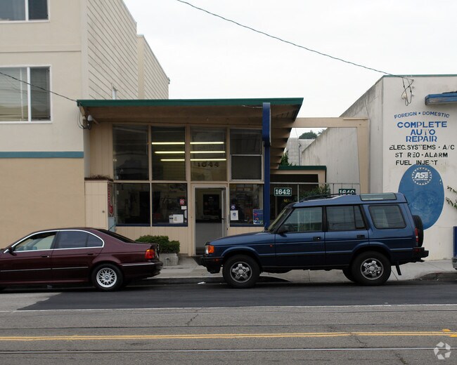
Property Record
1644 Taraval St, San Francisco, CA 94116

NEARBY LISTINGS FOR SALE OR LEASE
Property Detail
1644 Taraval St
San Francisco
Outside Land Bl #1127
San Francisco-Redwood City-South San Francisco, CA
BLK 1128
2355-012
San Francisco
Storemultistory
California
2024
12
2025
0.06 AC
032801
Southern City
1,380 SF
DEMOGRAPHICS near 1644 Taraval St
1 Mile
3 Mile
5 Mile
2024 Total Population
40,201
299,664
733,917
2029 Population
36,488
275,959
679,092
Pop Growth 2024-2029
(9.24%)
(7.91%)
(7.47%)
Average Age
45
43
43
2024 Total Households
13,830
114,456
293,361
HH Growth 2024-2029
(9.83%)
(8.30%)
(7.87%)
Median Household Inc
$134,921
$132,756
$123,856
Avg Household Size
2.80
2.50
2.40
2024 Avg HH Vehicles
2.00
1.00
1.00
Median Home Value
$1,124,400
$1,111,352
$1,093,758
Median Year Built
1946
1948
1948
Nearby Places
Map Layers
Map Styles
 Street
 Aerial
- Restaurants
- Banks
- Shops
- Fitness
- Groceries
PUBLIC TRANSPORTATION
TRANSIT/SUBWAY
Taraval and 26th Avenue (L Taraval - San Francisco Municipal Railway (MUNI Metro))
DRIVE
WALK
Distance
Taraval and 26th Avenue (L Taraval - San Francisco Municipal Railway (MUNI Metro))
1 min
1 min
0.0 mi
Taraval and 28th Avenue (L Taraval - San Francisco Municipal Railway (MUNI Metro))
DRIVE
WALK
Distance
Taraval and 28th Avenue (L Taraval - San Francisco Municipal Railway (MUNI Metro))
1 min
1 min
0.1 mi
Taraval and 24th Avenue (L Taraval - San Francisco Municipal Railway (MUNI Metro))
DRIVE
WALK
Distance
Taraval and 24th Avenue (L Taraval - San Francisco Municipal Railway (MUNI Metro))
1 min
3 min
0.2 mi
Taraval and 30th Avenue (L Taraval - San Francisco Municipal Railway (MUNI Metro))
DRIVE
WALK
Distance
Taraval and 30th Avenue (L Taraval - San Francisco Municipal Railway (MUNI Metro))
1 min
3 min
0.2 mi
Taraval and 23rd Avenue (L Taraval - San Francisco Municipal Railway (MUNI Metro))
DRIVE
WALK
Distance
Taraval and 23rd Avenue (L Taraval - San Francisco Municipal Railway (MUNI Metro))
1 min
4 min
0.2 mi
COMMUTER RAIL
22nd Street (Caltrain - Caltrain (Caltrain))
DRIVE
WALK
Distance
22nd Street (Caltrain - Caltrain (Caltrain))
18 min
9.2 mi
Bayshore (Caltrain - Caltrain (Caltrain))
DRIVE
WALK
Distance
Bayshore (Caltrain - Caltrain (Caltrain))
17 min
9.7 mi
AIRPORT
San Francisco International
DRIVE
WALK
Distance
San Francisco International
20 min
13.3 mi
Metro Oakland International
DRIVE
WALK
Distance
Metro Oakland International
42 min
29.2 mi
Freight Ports
Port of San Francisco
DRIVE
WALK
Distance
Port of San Francisco
1 min
6.1 mi
SALE & LEASE HISTORY
LISTING DATE
SALE/LEASE

Mar 10, 2017
For Sale
Nearby Properties
Address
Land Use
TOTAL SIZE
Lot Size
Zoning
Address
Land Use
TOTAL SIZE
Lot Size
Zoning
411,904 SF
21.74 AC
C2
Address
Land Use
TOTAL SIZE
Lot Size
Zoning
718 SF
18.55 AC
RH2
Address
Land Use
TOTAL SIZE
Lot Size
Zoning
4.41 AC
RH-3/RM-2
Address
Land Use
TOTAL SIZE
Lot Size
Zoning
230,310 SF
0.65 AC
NC3
Address
Land Use
TOTAL SIZE
Lot Size
Zoning
2.03 AC
C2
Address
Land Use
TOTAL SIZE
Lot Size
Zoning
88,900 SF
5.37 AC
NCS
Address
Land Use
TOTAL SIZE
Lot Size
Zoning
11.31 AC
RM2
Address
Land Use
TOTAL SIZE
Lot Size
Zoning
160,983 SF
1.84 AC
NC2
Address
Land Use
TOTAL SIZE
Lot Size
Zoning
90,539 SF
2.28 AC
RH2
Address
Land Use
TOTAL SIZE
Lot Size
Zoning
Address
Land Use
TOTAL SIZE
Lot Size
Zoning
73,491 SF
4.48 AC
C2
Address
Land Use
TOTAL SIZE
Lot Size
Zoning
12,555 SF
0.74 AC
NCS
Address
Land Use
TOTAL SIZE
Lot Size
Zoning
146,036 SF
0.49 AC
RH3
Address
Land Use
TOTAL SIZE
Lot Size
Zoning
176,000 SF
1.64 AC
C2
Address
Land Use
TOTAL SIZE
Lot Size
Zoning
54,131 SF
1.75 AC
C2
Address
Land Use
TOTAL SIZE
Lot Size
Zoning
76,000 SF
1.48 AC
RM4
Address
Land Use
TOTAL SIZE
Lot Size
Zoning
194,477 SF
11.37 AC
RH1
Address
Land Use
TOTAL SIZE
Lot Size
Zoning
87,525 SF
1.65 AC
RM1
Address
Land Use
TOTAL SIZE
Lot Size
Zoning
205,770 SF
3.37 AC
RM4
Address
Land Use
TOTAL SIZE
Lot Size
Zoning
6.80 AC
RM1
Address
Land Use
TOTAL SIZE
Lot Size
Zoning
81,756 SF
5.39 AC
RH1D
Address
Land Use
TOTAL SIZE
Lot Size
Zoning
257,754 SF
1.37 AC
Address
Land Use
TOTAL SIZE
Lot Size
Zoning
63,943 SF
0.77 AC
Address
Land Use
TOTAL SIZE
Lot Size
Zoning
89,274 SF
0.58 AC
NC3
Address
Land Use
TOTAL SIZE
Lot Size
Zoning
66,986 SF
4.91 AC
NCS
Address
Land Use
TOTAL SIZE
Lot Size
Zoning
2.01 AC
RM1
Address
Land Use
TOTAL SIZE
Lot Size
Zoning
136,892 SF
0.96 AC
Address
Land Use
TOTAL SIZE
Lot Size
Zoning
6.18 AC
RM1
Address
Land Use
TOTAL SIZE
Lot Size
Zoning
100,740 SF
2.57 AC
Address
Land Use
TOTAL SIZE
Lot Size
Zoning
132,880 SF
1.07 AC
The World's #1 Commercial Real Estate Marketplace
Connect with us
© 2026 CoStar Group
The information above has been obtained from sources believed reliable. While we do not doubt its accuracy we have not verified it and make no guarantee, warranty or representation about it. It is your responsibility to independently confirm its accuracy and completeness. Any projections, opinions, assumptions, or estimates used are for example only and do not represent the current or future performance of the property. The value of this transaction to you depends on tax and other factors which should be evaluated by your tax, financial, and legal advisors. You and your advisors should conduct a careful, independent investigation of the property to determine to your satisfaction the suitability of the property for your needs.