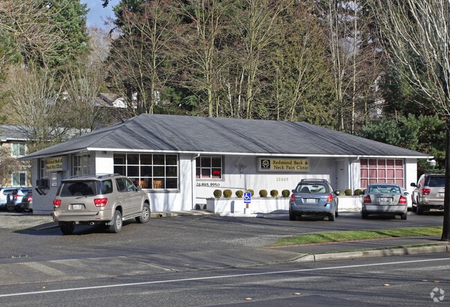
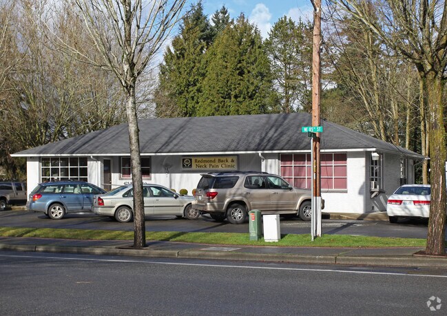
Property Record
16440 Ne 85Th St, Redmond, WA 98052
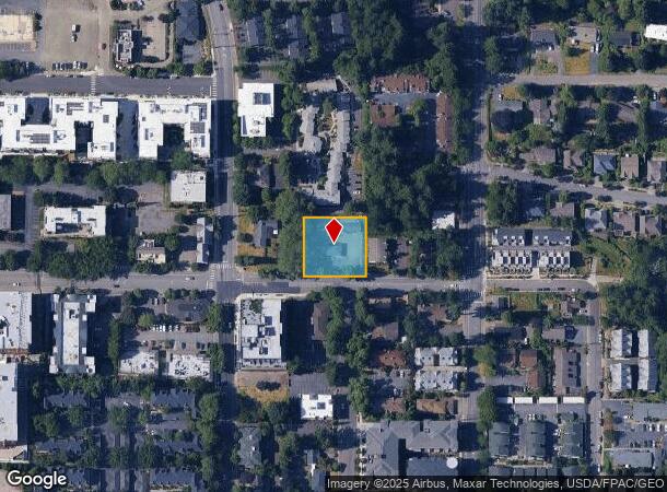

NEARBY LISTINGS FOR SALE OR LEASE
Property Detail
16440 Ne 85Th St
012505-9116
E 150 FT OF W 330 FT OF S 165 FT OF NW 1/4 OF SW 1/4 SEC 1-25-5 LESS S 20 FT THOF FOR ST
Officebuilding
King
X
Washington
53033C0386H
12505
2025
0.50 AC
2024
Redmond
032324
Seattle/Puget Sound
2,913 SF
Seattle-Tacoma-Bellevue, WA
DEMOGRAPHICS near 16440 Ne 85Th St
1 Mile
3 Mile
5 Mile
2024 Total Population
25,491
94,733
242,589
2029 Population
26,244
95,658
245,137
Pop Growth 2024-2029
+ 2.95%
+ 0.98%
+ 1.05%
Average Age
35
36
38
2024 Total Households
11,883
37,583
96,853
HH Growth 2024-2029
+ 3.04%
+ 1.03%
+ 1.12%
Median Household Inc
$134,122
$153,516
$150,293
Avg Household Size
2.10
2.50
2.40
2024 Avg HH Vehicles
1.00
2.00
2.00
Median Home Value
$815,741
$1,016,639
$1,010,379
Median Year Built
2002
1990
1987
Nearby Places
Map Layers
Map Styles
 Street
 Aerial
- Restaurants
- Banks
- Shops
- Fitness
- Groceries
PUBLIC TRANSPORTATION
AIRPORT
Seattle Paine Field International
DRIVE
WALK
Distance
Seattle Paine Field International
34 min
21.2 mi
Seattle-Tacoma International
DRIVE
WALK
Distance
Seattle-Tacoma International
36 min
24.1 mi
Freight Ports
Port of Seattle
DRIVE
WALK
Distance
Port of Seattle
31 min
19.9 mi
Nearby Properties
Address
Land Use
TOTAL SIZE
Lot Size
Zoning
Address
Land Use
TOTAL SIZE
Lot Size
Zoning
146,798 SF
19.63 AC
OBAT
Address
Land Use
TOTAL SIZE
Lot Size
Zoning
424,532 SF
30.49 AC
OUMF
Address
Land Use
TOTAL SIZE
Lot Size
Zoning
368,500 SF
38 AC
NR
Address
Land Use
TOTAL SIZE
Lot Size
Zoning
342,000 SF
24.18 AC
OUMF
Address
Land Use
TOTAL SIZE
Lot Size
Zoning
364,208 SF
16.94 AC
NMF
Address
Land Use
TOTAL SIZE
Lot Size
Zoning
231,088 SF
2.10 AC
TWNC
Address
Land Use
TOTAL SIZE
Lot Size
Zoning
270,158 SF
3.03 AC
TSQ
Address
Land Use
TOTAL SIZE
Lot Size
Zoning
279,488 SF
20.82 AC
NMF
Address
Land Use
TOTAL SIZE
Lot Size
Zoning
282,532 SF
16.57 AC
NMF
Address
Land Use
TOTAL SIZE
Lot Size
Zoning
209,400 SF
1.80 AC
TSQ
Address
Land Use
TOTAL SIZE
Lot Size
Zoning
65,000 SF
13.57 AC
EH
Address
Land Use
TOTAL SIZE
Lot Size
Zoning
298,849 SF
3.99 AC
OBAT
Address
Land Use
TOTAL SIZE
Lot Size
Zoning
300,628 SF
4.43 AC
OBAT
Address
Land Use
TOTAL SIZE
Lot Size
Zoning
82,451 SF
15.02 AC
BP
Address
Land Use
TOTAL SIZE
Lot Size
Zoning
393,897 SF
10.05 AC
OBAT
Address
Land Use
TOTAL SIZE
Lot Size
Zoning
125,996 SF
7.57 AC
TWNC
Address
Land Use
TOTAL SIZE
Lot Size
Zoning
136,191 SF
7.23 AC
TWNC
Address
Land Use
TOTAL SIZE
Lot Size
Zoning
288,288 SF
22.21 AC
NMF
Address
Land Use
TOTAL SIZE
Lot Size
Zoning
15,512 SF
3.03 AC
MDD5
Address
Land Use
TOTAL SIZE
Lot Size
Zoning
98,914 SF
10.38 AC
SMT
Address
Land Use
TOTAL SIZE
Lot Size
Zoning
265,634 SF
3.60 AC
OBAT
Address
Land Use
TOTAL SIZE
Lot Size
Zoning
265,753 SF
5.05 AC
OBAT
Address
Land Use
TOTAL SIZE
Lot Size
Zoning
161,172 SF
2.77 AC
MDD3
Address
Land Use
TOTAL SIZE
Lot Size
Zoning
173,119 SF
1.50 AC
SMT
Address
Land Use
TOTAL SIZE
Lot Size
Zoning
21,828 SF
9.18 AC
OBAT
Address
Land Use
TOTAL SIZE
Lot Size
Zoning
280,034 SF
29.58 AC
MP
Address
Land Use
TOTAL SIZE
Lot Size
Zoning
214,385 SF
12.80 AC
R-20
Address
Land Use
TOTAL SIZE
Lot Size
Zoning
249,064 SF
16.37 AC
R-20
Address
Land Use
TOTAL SIZE
Lot Size
Zoning
244,933 SF
13.90 AC
NMF
Address
Land Use
TOTAL SIZE
Lot Size
Zoning
219,190 SF
6.71 AC
GC
The World's #1 Commercial Real Estate Marketplace
Connect with us
© 2026 CoStar Group
The information above has been obtained from sources believed reliable. While we do not doubt its accuracy we have not verified it and make no guarantee, warranty or representation about it. It is your responsibility to independently confirm its accuracy and completeness. Any projections, opinions, assumptions, or estimates used are for example only and do not represent the current or future performance of the property. The value of this transaction to you depends on tax and other factors which should be evaluated by your tax, financial, and legal advisors. You and your advisors should conduct a careful, independent investigation of the property to determine to your satisfaction the suitability of the property for your needs.