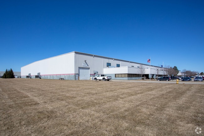
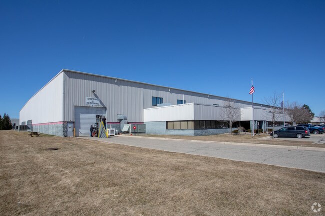
Property Record
16445 23 Mile Rd, Macomb, MI 48042

NEARBY LISTINGS FOR SALE OR LEASE
Property Detail
16445 23 Mile Rd
20-08-18-400-013
T3N R13E SEC 18; COMM AT SE COR SEC 18; TH S89*41'35"W 332.25 FT TO POB; TH S89*41'35"W 710.0 FT; TH N00*08'08"W 1425.82 FT;
Lightindustrial
Macomb
X
Michigan
26099C0237G
22.26 AC
2025
Groesbeck North
2025
Detroit
223902
Detroit-Warren-Dearborn, MI
214,282 SF
DEMOGRAPHICS near 16445 23 Mile Rd
1 Mile
3 Mile
5 Mile
2024 Total Population
6,638
81,488
186,252
2029 Population
6,528
80,232
183,904
Pop Growth 2024-2029
(1.66%)
(1.54%)
(1.26%)
Average Age
45
41
41
2024 Total Households
2,589
28,102
71,144
HH Growth 2024-2029
(1.78%)
(1.72%)
(1.33%)
Median Household Inc
$98,254
$109,490
$88,274
Avg Household Size
2.60
2.90
2.60
2024 Avg HH Vehicles
2.00
2.00
2.00
Median Home Value
$311,761
$325,158
$297,720
Median Year Built
1997
1996
1993
Nearby Places
Map Layers
Map Styles
 Street
 Aerial
- Restaurants
- Banks
- Shops
- Fitness
- Groceries
PUBLIC TRANSPORTATION
AIRPORT
Windsor International
DRIVE
WALK
Distance
Windsor International
68 min
41.9 mi
Freight Ports
Port of Toledo
DRIVE
WALK
Distance
Port of Toledo
119 min
92.4 mi
Nearby Properties
Address
Land Use
TOTAL SIZE
Lot Size
Zoning
Address
Land Use
TOTAL SIZE
Lot Size
Zoning
20,560 SF
37.09 AC
R2
Address
Land Use
TOTAL SIZE
Lot Size
Zoning
447,434 SF
23.29 AC
LM
Address
Land Use
TOTAL SIZE
Lot Size
Zoning
371,520 SF
21.91 AC
CK MAP
Address
Land Use
TOTAL SIZE
Lot Size
Zoning
89,559 SF
44.54 AC
O2
Address
Land Use
TOTAL SIZE
Lot Size
Zoning
118,343 SF
7.33 AC
R1
Address
Land Use
TOTAL SIZE
Lot Size
Zoning
10.29 AC
LM
Address
Land Use
TOTAL SIZE
Lot Size
Zoning
90,185 SF
14.73 AC
C2
Address
Land Use
TOTAL SIZE
Lot Size
Zoning
224,323 SF
22.15 AC
C-3
Address
Land Use
TOTAL SIZE
Lot Size
Zoning
17.40 AC
CK MAP
Address
Land Use
TOTAL SIZE
Lot Size
Zoning
73.49 AC
CK MAP
Address
Land Use
TOTAL SIZE
Lot Size
Zoning
79,942 SF
4.65 AC
M1
Address
Land Use
TOTAL SIZE
Lot Size
Zoning
120,658 SF
13.97 AC
C-3
Address
Land Use
TOTAL SIZE
Lot Size
Zoning
121,156 SF
9.40 AC
CK MAP
Address
Land Use
TOTAL SIZE
Lot Size
Zoning
293,800 SF
M1
Address
Land Use
TOTAL SIZE
Lot Size
Zoning
134,400 SF
7.55 AC
CK MAP
Address
Land Use
TOTAL SIZE
Lot Size
Zoning
14.46 AC
R-7
Address
Land Use
TOTAL SIZE
Lot Size
Zoning
122,540 SF
CK MAP
Address
Land Use
TOTAL SIZE
Lot Size
Zoning
150,854 SF
8.50 AC
LM
Address
Land Use
TOTAL SIZE
Lot Size
Zoning
148,438 SF
4.82 AC
LM
Address
Land Use
TOTAL SIZE
Lot Size
Zoning
99,619 SF
8.24 AC
M1
Address
Land Use
TOTAL SIZE
Lot Size
Zoning
74,354 SF
10.62 AC
C3
Address
Land Use
TOTAL SIZE
Lot Size
Zoning
82,700 SF
9.75 AC
R-6
Address
Land Use
TOTAL SIZE
Lot Size
Zoning
37.96 AC
AG
Address
Land Use
TOTAL SIZE
Lot Size
Zoning
312,087 SF
25.65 AC
M1
Address
Land Use
TOTAL SIZE
Lot Size
Zoning
56,766 SF
5.06 AC
C2
Address
Land Use
TOTAL SIZE
Lot Size
Zoning
99,188 SF
7.99 AC
LM
Address
Land Use
TOTAL SIZE
Lot Size
Zoning
4,064 SF
99.99 AC
R3
Address
Land Use
TOTAL SIZE
Lot Size
Zoning
104,455 SF
15.28 AC
LM
Address
Land Use
TOTAL SIZE
Lot Size
Zoning
15.04 AC
C-5
The World's #1 Commercial Real Estate Marketplace
Connect with us
© 2025 CoStar Group
The information above has been obtained from sources believed reliable. While we do not doubt its accuracy we have not verified it and make no guarantee, warranty or representation about it. It is your responsibility to independently confirm its accuracy and completeness. Any projections, opinions, assumptions, or estimates used are for example only and do not represent the current or future performance of the property. The value of this transaction to you depends on tax and other factors which should be evaluated by your tax, financial, and legal advisors. You and your advisors should conduct a careful, independent investigation of the property to determine to your satisfaction the suitability of the property for your needs.