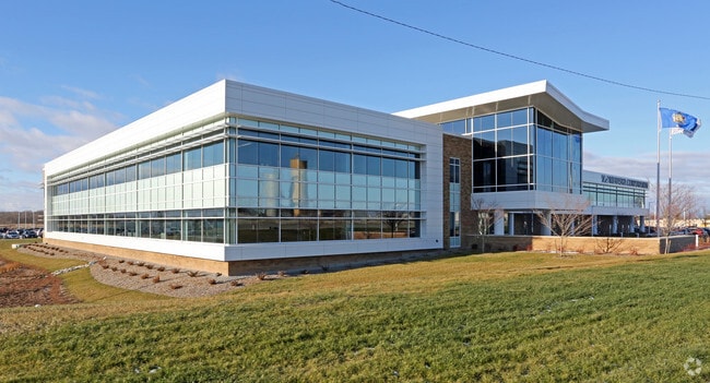
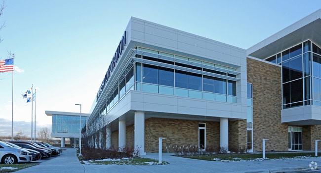
Property Record
1645 Bergstrom Rd, Neenah, WI 54956

Save to a Folder
{{folder.Name}}
{{folder.ListingIds.length}} Properties
{{folder.ListingIds.length}} Property
Create a New Folder
Property Detail
1645 Bergstrom Rd
06-4500-0000
A PARCEL OF LAND PART OF W OF SE AND THE E OF SW OF SE CTION 5-19-17 AS DESCRIBED IN DOC 625663 ANNEXED 2/7/1985 LE SS ANY LANDS ACQUIRED OR NOW US ED FOR HIGHWAY PURPOSES AS DESC RIBED IN DOC 444354. 29.845 A CRES +/-
Industrialgeneral
WINNEBAGO
I1
Wisconsin
C and X Area of minimal flood hazard, usually depicted on FIRMs as above the 500-year flood level.
29.32 AC
0
Appleton/Oshkosh
2025
Other Market Areas
003703
Oshkosh-Neenah, WI
NEARBY LISTINGS FOR SALE OR LEASE
DEMOGRAPHICS near 1645 Bergstrom Rd
1 mile
3 mile
5 mile
2025 Total Population
2,190
27,046
44,024
2030 Population
2,211
27,261
44,520
Pop Growth 2025-2030
+ 0.96%
+ 0.79%
+ 1.13%
Average Age
39
41
41
2025 Total Households
848
11,333
18,482
HH Growth 2025-2030
+ 0.83%
+ 0.79%
+ 1.08%
Median Household Inc
$99,999
$78,196
$75,373
Avg Household Size
2.50
2.30
2.30
2025 Avg HH Vehicles
2.00
2.00
2.00
Median Home Value
$331,162
$238,908
$233,851
Median Year Built
1997
1973
1971
Nearby Places
Map Layers
Map Styles
 Street
 Aerial
Layers
 Traffic
 Biking
Places
Listings with unknown addresses are not visible on the map
- Restaurants
- Banks
- Shops
- Fitness
- Groceries
PUBLIC TRANSPORTATION
AIRPORT
Appleton International
Drive
Walk
Distance
Appleton International
19 min
11.0 mi
Green Bay/Austin Straubel International
Drive
Walk
Distance
Green Bay/Austin Straubel International
49 min
38.8 mi
Freight Ports
Port Milwaukee
Drive
Walk
Distance
Port Milwaukee
118 min
99.7 mi
Nearby Properties
Address
Land Use
TOTAL SIZE
Lot Size
Zoning
Address
Land Use
TOTAL SIZE
Lot Size
Zoning
1,975 SF
2.40 AC
M2
Address
Land Use
TOTAL SIZE
Lot Size
Zoning
Address
Land Use
TOTAL SIZE
Lot Size
Zoning
800 SF
19.84 AC
I1
Address
Land Use
TOTAL SIZE
Lot Size
Zoning
59,584 SF
12.11 AC
C1
Address
Land Use
TOTAL SIZE
Lot Size
Zoning
32.54 AC
Address
Land Use
TOTAL SIZE
Lot Size
Zoning
67.41 AC
I2
Address
Land Use
TOTAL SIZE
Lot Size
Zoning
210,214 SF
16.44 AC
I1
Address
Land Use
TOTAL SIZE
Lot Size
Zoning
361,899 SF
18.54 AC
I2
Address
Land Use
TOTAL SIZE
Lot Size
Zoning
115,151 SF
11.71 AC
PDD
Address
Land Use
TOTAL SIZE
Lot Size
Zoning
139,871 SF
11.14 AC
C1
Address
Land Use
TOTAL SIZE
Lot Size
Zoning
74,603 SF
4.96 AC
I1
Address
Land Use
TOTAL SIZE
Lot Size
Zoning
145,322 SF
11.20 AC
PDD
Address
Land Use
TOTAL SIZE
Lot Size
Zoning
92,039 SF
13.55 AC
I2
Address
Land Use
TOTAL SIZE
Lot Size
Zoning
9.27 AC
I1
Address
Land Use
TOTAL SIZE
Lot Size
Zoning
92,030 SF
7.79 AC
I1
Address
Land Use
TOTAL SIZE
Lot Size
Zoning
48,933 SF
2.80 AC
PDD
Address
Land Use
TOTAL SIZE
Lot Size
Zoning
22.72 AC
I1
Address
Land Use
TOTAL SIZE
Lot Size
Zoning
6.61 AC
I2
Address
Land Use
TOTAL SIZE
Lot Size
Zoning
37,672 SF
5.26 AC
PDD
Address
Land Use
TOTAL SIZE
Lot Size
Zoning
117,640 SF
7.45 AC
I1
Address
Land Use
TOTAL SIZE
Lot Size
Zoning
160,920 SF
7.89 AC
M2
Address
Land Use
TOTAL SIZE
Lot Size
Zoning
160,920 SF
7.98 AC
M2
Address
Land Use
TOTAL SIZE
Lot Size
Zoning
107,703 SF
4.63 AC
I2
Address
Land Use
TOTAL SIZE
Lot Size
Zoning
253,191 SF
18.75 AC
I2
Address
Land Use
TOTAL SIZE
Lot Size
Zoning
50,652 SF
8.51 AC
C1
Address
Land Use
TOTAL SIZE
Lot Size
Zoning
12,920 SF
4.96 AC
M2
Address
Land Use
TOTAL SIZE
Lot Size
Zoning
192,120 SF
11.41 AC
I1
Address
Land Use
TOTAL SIZE
Lot Size
Zoning
11.20 AC
Address
Land Use
TOTAL SIZE
Lot Size
Zoning
57,721 SF
7.51 AC
PDD
The World's #1 Commercial Real Estate Marketplace
Connect with us
© 2026 CoStar Group
The information above has been obtained from sources believed reliable. While we do not doubt its accuracy we have not verified it and make no guarantee, warranty or representation about it. It is your responsibility to independently confirm its accuracy and completeness. Any projections, opinions, assumptions, or estimates used are for example only and do not represent the current or future performance of the property. The value of this transaction to you depends on tax and other factors which should be evaluated by your tax, financial, and legal advisors. You and your advisors should conduct a careful, independent investigation of the property to determine to your satisfaction the suitability of the property for your needs.