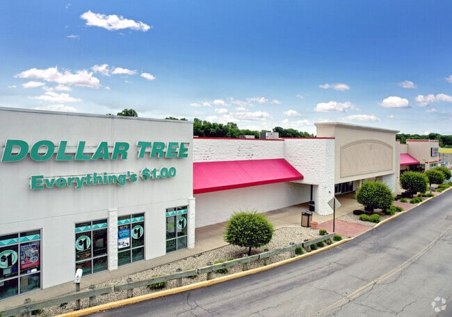
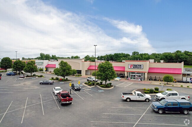
Property Record
1645 N State St, Greenfield, IN 46140
NEARBY LISTINGS FOR SALE OR LEASE
Property Detail
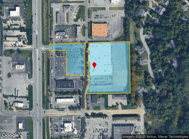
1645 N State St
30-07-29-102-001.003-009
WALNUT HILLS PLAZA S 2 L 17 REPLAT OF L 4 5.895
Stripcommercialcenter
Hancock
X
Indiana
18059C0142D
5.90 AC
2024
Hancock County
2024
Indianapolis
410600
Indianapolis-Carmel-Anderson, IN
65,684 SF
DEMOGRAPHICS near 1645 N State St
1 Mile
3 Mile
5 Mile
2024 Total Population
7,032
27,118
33,822
2029 Population
7,753
30,013
37,336
Pop Growth 2024-2029
+ 10.25%
+ 10.68%
+ 10.39%
Average Age
42
40
41
2024 Total Households
2,938
11,013
13,653
HH Growth 2024-2029
+ 10.65%
+ 11.03%
+ 10.75%
Median Household Inc
$73,294
$71,447
$73,132
Avg Household Size
2.30
2.40
2.40
2024 Avg HH Vehicles
2.00
2.00
2.00
Median Home Value
$175,742
$169,639
$176,223
Median Year Built
1988
1993
1991
Nearby Places
Map Layers
Map Styles
 Street
 Aerial
- Restaurants
- Banks
- Shops
- Fitness
- Groceries
PUBLIC TRANSPORTATION
AIRPORT
Indianapolis International
DRIVE
WALK
Distance
Indianapolis International
55 min
37.5 mi
Freight Ports
Port of Toledo
DRIVE
WALK
Distance
Port of Toledo
255 min
208.2 mi
SALE & LEASE HISTORY
LISTING DATE
SALE/LEASE

Mar 15, 2017
For Lease
Nearby Properties
Address
Land Use
TOTAL SIZE
Lot Size
Zoning
Address
Land Use
TOTAL SIZE
Lot Size
Zoning
505,100 SF
22.47 AC
Address
Land Use
TOTAL SIZE
Lot Size
Zoning
1,001,373 SF
81.13 AC
Address
Land Use
TOTAL SIZE
Lot Size
Zoning
294,173 SF
38.43 AC
Address
Land Use
TOTAL SIZE
Lot Size
Zoning
13,428 SF
23 AC
Address
Land Use
TOTAL SIZE
Lot Size
Zoning
26,680 SF
20.64 AC
Address
Land Use
TOTAL SIZE
Lot Size
Zoning
704 SF
41.46 AC
Address
Land Use
TOTAL SIZE
Lot Size
Zoning
17,606 SF
21.29 AC
Address
Land Use
TOTAL SIZE
Lot Size
Zoning
14,120 SF
21.75 AC
Address
Land Use
TOTAL SIZE
Lot Size
Zoning
423,054 SF
113.86 AC
Address
Land Use
TOTAL SIZE
Lot Size
Zoning
243,574 SF
19.92 AC
Address
Land Use
TOTAL SIZE
Lot Size
Zoning
185,826 SF
20.54 AC
Address
Land Use
TOTAL SIZE
Lot Size
Zoning
49,600 SF
4.27 AC
Address
Land Use
TOTAL SIZE
Lot Size
Zoning
219,354 SF
9.95 AC
Address
Land Use
TOTAL SIZE
Lot Size
Zoning
184,512 SF
Address
Land Use
TOTAL SIZE
Lot Size
Zoning
229,786 SF
16 AC
Address
Land Use
TOTAL SIZE
Lot Size
Zoning
70,256 SF
1.13 AC
Address
Land Use
TOTAL SIZE
Lot Size
Zoning
195,134 SF
Address
Land Use
TOTAL SIZE
Lot Size
Zoning
52,809 SF
6.52 AC
Address
Land Use
TOTAL SIZE
Lot Size
Zoning
87,810 SF
10.45 AC
Address
Land Use
TOTAL SIZE
Lot Size
Zoning
115,758 SF
7.10 AC
Address
Land Use
TOTAL SIZE
Lot Size
Zoning
84,332 SF
28.27 AC
Address
Land Use
TOTAL SIZE
Lot Size
Zoning
72,791 SF
9.52 AC
Address
Land Use
TOTAL SIZE
Lot Size
Zoning
88,200 SF
10.86 AC
Address
Land Use
TOTAL SIZE
Lot Size
Zoning
121,800 SF
7.43 AC
Address
Land Use
TOTAL SIZE
Lot Size
Zoning
43,012 SF
2.02 AC
Address
Land Use
TOTAL SIZE
Lot Size
Zoning
72,696 SF
6.29 AC
Address
Land Use
TOTAL SIZE
Lot Size
Zoning
39,384 SF
5.57 AC
Address
Land Use
TOTAL SIZE
Lot Size
Zoning
46,690 SF
2.08 AC
Address
Land Use
TOTAL SIZE
Lot Size
Zoning
95,020 SF
9.38 AC
Address
Land Use
TOTAL SIZE
Lot Size
Zoning
82,560 SF
14.09 AC
The World's #1 Commercial Real Estate Marketplace
Connect with us
© 2026 CoStar Group
The information above has been obtained from sources believed reliable. While we do not doubt its accuracy we have not verified it and make no guarantee, warranty or representation about it. It is your responsibility to independently confirm its accuracy and completeness. Any projections, opinions, assumptions, or estimates used are for example only and do not represent the current or future performance of the property. The value of this transaction to you depends on tax and other factors which should be evaluated by your tax, financial, and legal advisors. You and your advisors should conduct a careful, independent investigation of the property to determine to your satisfaction the suitability of the property for your needs.