Property Record
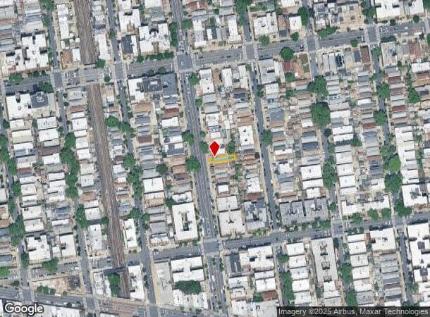
1645 W 6Th St, Brooklyn, NY 11223
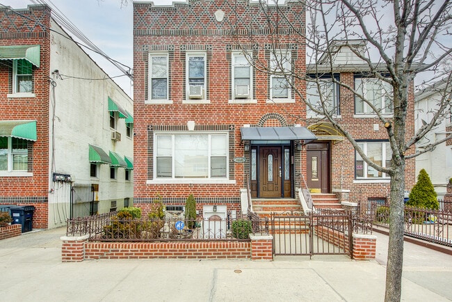
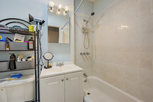
This Property Is For Sale
NEARBY LISTINGS FOR SALE OR LEASE
Property Detail
1645 W 6Th St
New York-Jersey City-White Plains, NY-NJ
Kings
06626-0060
New York
Duplex
0.05 AC
X
Gravesend
3604970351F
Long Island (New York)
3,220 SF
DEMOGRAPHICS near 1645 W 6Th St
1 Mile
3 Mile
5 Mile
2024 Total Population
135,689
928,783
1,530,479
2029 Population
123,979
859,681
1,420,963
Pop Growth 2024-2029
(8.63%)
(7.44%)
(7.16%)
Average Age
40
40
40
2024 Total Households
44,777
316,426
544,297
HH Growth 2024-2029
(9.33%)
(7.79%)
(7.46%)
Median Household Inc
$62,694
$62,888
$69,516
Avg Household Size
2.90
2.80
2.70
2024 Avg HH Vehicles
1.00
1.00
1.00
Median Home Value
$951,639
$811,441
$809,789
Median Year Built
1947
1948
1948
Nearby Places
- Restaurants
- Banks
- Shops
- Fitness
- Groceries
PUBLIC TRANSPORTATION
TRANSIT/SUBWAY
Kings Highway (N Line) (N - New York MTA Subway (The Subway))
DRIVE
WALK
Distance
Kings Highway (N Line) (N - New York MTA Subway (The Subway))
1 min
6 min
0.3 mi
Bay Parkway (N Line) (N - New York MTA Subway (The Subway))
DRIVE
WALK
Distance
Bay Parkway (N Line) (N - New York MTA Subway (The Subway))
2 min
8 min
0.4 mi
Avenue P (F - New York MTA Subway (The Subway))
DRIVE
WALK
Distance
Avenue P (F - New York MTA Subway (The Subway))
1 min
9 min
0.4 mi
Kings Highway (F Line) (F - New York MTA Subway (The Subway))
DRIVE
WALK
Distance
Kings Highway (F Line) (F - New York MTA Subway (The Subway))
2 min
11 min
0.6 mi
Avenue N (F - New York MTA Subway (The Subway))
DRIVE
WALK
Distance
Avenue N (F - New York MTA Subway (The Subway))
2 min
15 min
0.8 mi
COMMUTER RAIL
Nostrand Avenue Station (Far Rockaway Branch - Long Island Rail Road, Hempstead Branch - Long Island Rail Road, Long Beach Branch - Long Island Rail Road, West Hempstead Branch - Long Island Rail Road)
DRIVE
WALK
Distance
Nostrand Avenue Station (Far Rockaway Branch - Long Island Rail Road, Hempstead Branch - Long Island Rail Road, Long Beach Branch - Long Island Rail Road, West Hempstead Branch - Long Island Rail Road)
16 min
6.5 mi
DRIVE
WALK
Distance
15 min
6.7 mi
AIRPORT
John F Kennedy International
DRIVE
WALK
Distance
John F Kennedy International
25 min
14.2 mi
LaGuardia
DRIVE
WALK
Distance
LaGuardia
32 min
17.6 mi
Newark Liberty International
DRIVE
WALK
Distance
Newark Liberty International
36 min
21.2 mi
Freight Ports
NY - Red Hook Container Terminal
DRIVE
WALK
Distance
NY - Red Hook Container Terminal
12 min
6.5 mi
Nearby Properties
Address
Land Use
TOTAL SIZE
Lot Size
Zoning
Address
Land Use
TOTAL SIZE
Lot Size
Zoning
1,524,659 SF
170.96 AC
R4
Address
Land Use
TOTAL SIZE
Lot Size
Zoning
1,078,317 SF
10.45 AC
R4
Address
Land Use
TOTAL SIZE
Lot Size
Zoning
965,600 SF
6.65 AC
R5
Address
Land Use
TOTAL SIZE
Lot Size
Zoning
1,073,920 SF
16.53 AC
R6
Address
Land Use
TOTAL SIZE
Lot Size
Zoning
335,800 SF
1.51 AC
R6
Address
Land Use
TOTAL SIZE
Lot Size
Zoning
54.78 AC
PARK
Address
Land Use
TOTAL SIZE
Lot Size
Zoning
785,450 SF
14.22 AC
R6
Address
Land Use
TOTAL SIZE
Lot Size
Zoning
241,735 SF
1.99 AC
C8-4
Address
Land Use
TOTAL SIZE
Lot Size
Zoning
301,400 SF
22.27 AC
M3-1
Address
Land Use
TOTAL SIZE
Lot Size
Zoning
75,340 SF
3.02 AC
PARK
Address
Land Use
TOTAL SIZE
Lot Size
Zoning
139,557 SF
11.47 AC
M1-1
Address
Land Use
TOTAL SIZE
Lot Size
Zoning
846,056 SF
20.71 AC
R5
Address
Land Use
TOTAL SIZE
Lot Size
Zoning
59,063 SF
21.56 AC
PARK
Address
Land Use
TOTAL SIZE
Lot Size
Zoning
209,346 SF
18.29 AC
PARK
Address
Land Use
TOTAL SIZE
Lot Size
Zoning
702,770 SF
4.47 AC
R6
Address
Land Use
TOTAL SIZE
Lot Size
Zoning
292,528 SF
1.05 AC
R6
Address
Land Use
TOTAL SIZE
Lot Size
Zoning
152,440 SF
23.07 AC
R4B
Address
Land Use
TOTAL SIZE
Lot Size
Zoning
356,000 SF
8.19 AC
R5
Address
Land Use
TOTAL SIZE
Lot Size
Zoning
351,762 SF
1.65 AC
R7A
Address
Land Use
TOTAL SIZE
Lot Size
Zoning
208,015 SF
1.52 AC
R7X
Address
Land Use
TOTAL SIZE
Lot Size
Zoning
221,704 SF
0.83 AC
R5B
Address
Land Use
TOTAL SIZE
Lot Size
Zoning
822,192 SF
14.15 AC
R6
Address
Land Use
TOTAL SIZE
Lot Size
Zoning
128,170 SF
0.87 AC
R7A
Address
Land Use
TOTAL SIZE
Lot Size
Zoning
470,000 SF
3.40 AC
R6
Address
Land Use
TOTAL SIZE
Lot Size
Zoning
16,570 SF
240.82 AC
PARK
Address
Land Use
TOTAL SIZE
Lot Size
Zoning
105,328 SF
0.11 AC
M1-6
Address
Land Use
TOTAL SIZE
Lot Size
Zoning
23,578 SF
37.05 AC
PARK
Address
Land Use
TOTAL SIZE
Lot Size
Zoning
521,976 SF
13.59 AC
R5
Address
Land Use
TOTAL SIZE
Lot Size
Zoning
131,650 SF
0.83 AC
R6
Address
Land Use
TOTAL SIZE
Lot Size
Zoning
2,000 SF
73.29 AC
PARK
The World's #1 Commercial Real Estate Marketplace
Connect with us
© 2025 CoStar Group
The information above has been obtained from sources believed reliable. While we do not doubt its accuracy we have not verified it and make no guarantee, warranty or representation about it. It is your responsibility to independently confirm its accuracy and completeness. Any projections, opinions, assumptions, or estimates used are for example only and do not represent the current or future performance of the property. The value of this transaction to you depends on tax and other factors which should be evaluated by your tax, financial, and legal advisors. You and your advisors should conduct a careful, independent investigation of the property to determine to your satisfaction the suitability of the property for your needs.