Property Record
16470 W Russell Rd, Wadsworth, IL 60083


NEARBY LISTINGS FOR SALE OR LEASE
-
-
View all Wadsworth listings for sale on LoopNet.com
Property Detail
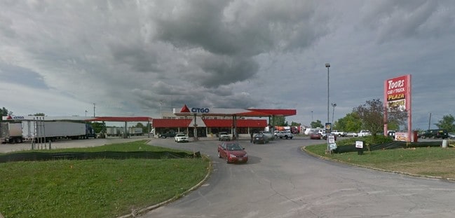
16470 W Russell Rd
03-04-400-021
PT E1/2 FRACL;BEG ELN HWY 41 AT PNT 60N OF SLN,ELY 720.069 ,NE 92.785,N 468.15,W TO ELN HWY 41,S TO POB(EX COM LN HWY 41 60N OF SLN,E 451.32 FOR POB,NLY 37.78,E 283.76,N 91.
Commercialbuilding
Lake
A
Illinois
17097C0055K
9.36 AC
2023
Far North
2024
Chicago
866000
Chicago-Naperville-Elgin, IL-IN-WI
9,558 SF
DEMOGRAPHICS near 16470 W Russell Rd
1 Mile
3 Mile
5 Mile
2024 Total Population
165
1,624
22,692
2029 Population
159
1,591
22,479
Pop Growth 2024-2029
(3.64%)
(2.03%)
(0.94%)
Average Age
44
42
40
2024 Total Households
60
648
8,221
HH Growth 2024-2029
(3.33%)
(2.01%)
(1.00%)
Median Household Inc
$99,999
$88,341
$95,160
Avg Household Size
2.70
2.40
2.70
2024 Avg HH Vehicles
2.00
2.00
2.00
Median Home Value
$428,571
$380,692
$265,084
Median Year Built
1981
1987
1996
Nearby Places
Map Layers
Map Styles
 Street
 Aerial
- Restaurants
- Banks
- Shops
- Fitness
- Groceries
PUBLIC TRANSPORTATION
COMMUTER RAIL
Antioch Station (North Central Service - Northeast Illinois Regional Commuter Railroad (Metra))
DRIVE
WALK
Distance
Antioch Station (North Central Service - Northeast Illinois Regional Commuter Railroad (Metra))
14 min
8.5 mi
Winthrop Harbor Station (Union Pacific North Line - Northeast Illinois Regional Commuter Railroad (Metra))
DRIVE
WALK
Distance
Winthrop Harbor Station (Union Pacific North Line - Northeast Illinois Regional Commuter Railroad (Metra))
18 min
9.6 mi
Freight Ports
Port Milwaukee
DRIVE
WALK
Distance
Port Milwaukee
46 min
38.0 mi
Nearby Properties
Address
Land Use
TOTAL SIZE
Lot Size
Zoning
Address
Land Use
TOTAL SIZE
Lot Size
Zoning
1,083,094 SF
230.85 AC
Address
Land Use
TOTAL SIZE
Lot Size
Zoning
75,755 SF
19.27 AC
Address
Land Use
TOTAL SIZE
Lot Size
Zoning
51,119 SF
63.71 AC
Address
Land Use
TOTAL SIZE
Lot Size
Zoning
12.53 AC
Address
Land Use
TOTAL SIZE
Lot Size
Zoning
108,727 SF
67.52 AC
Address
Land Use
TOTAL SIZE
Lot Size
Zoning
590,185 SF
46.90 AC
Address
Land Use
TOTAL SIZE
Lot Size
Zoning
301,652 SF
43.52 AC
Address
Land Use
TOTAL SIZE
Lot Size
Zoning
519,602 SF
28.36 AC
Address
Land Use
TOTAL SIZE
Lot Size
Zoning
38,201 SF
16 AC
Address
Land Use
TOTAL SIZE
Lot Size
Zoning
502,033 SF
28.13 AC
Address
Land Use
TOTAL SIZE
Lot Size
Zoning
451,756 SF
30.06 AC
Address
Land Use
TOTAL SIZE
Lot Size
Zoning
534,436 SF
35.50 AC
Address
Land Use
TOTAL SIZE
Lot Size
Zoning
418,133 SF
26.21 AC
Address
Land Use
TOTAL SIZE
Lot Size
Zoning
250,110 SF
17.13 AC
Address
Land Use
TOTAL SIZE
Lot Size
Zoning
410,694 SF
25.36 AC
Address
Land Use
TOTAL SIZE
Lot Size
Zoning
12,794 SF
16.75 AC
Address
Land Use
TOTAL SIZE
Lot Size
Zoning
77,776 SF
36.16 AC
Address
Land Use
TOTAL SIZE
Lot Size
Zoning
377,582 SF
28.48 AC
Address
Land Use
TOTAL SIZE
Lot Size
Zoning
396,508 SF
21.72 AC
Address
Land Use
TOTAL SIZE
Lot Size
Zoning
21.62 AC
Address
Land Use
TOTAL SIZE
Lot Size
Zoning
239,151 SF
14.13 AC
Address
Land Use
TOTAL SIZE
Lot Size
Zoning
108,539 SF
20.08 AC
Address
Land Use
TOTAL SIZE
Lot Size
Zoning
205,028 SF
12.78 AC
Address
Land Use
TOTAL SIZE
Lot Size
Zoning
105,600 SF
15.75 AC
Address
Land Use
TOTAL SIZE
Lot Size
Zoning
162,500 SF
15.85 AC
Address
Land Use
TOTAL SIZE
Lot Size
Zoning
73,272 SF
5.60 AC
Address
Land Use
TOTAL SIZE
Lot Size
Zoning
558,250 SF
25.28 AC
Address
Land Use
TOTAL SIZE
Lot Size
Zoning
50.32 AC
Address
Land Use
TOTAL SIZE
Lot Size
Zoning
79,068 SF
9.24 AC
Address
Land Use
TOTAL SIZE
Lot Size
Zoning
43,134 SF
2.88 AC
The World's #1 Commercial Real Estate Marketplace
Connect with us
© 2026 CoStar Group
The information above has been obtained from sources believed reliable. While we do not doubt its accuracy we have not verified it and make no guarantee, warranty or representation about it. It is your responsibility to independently confirm its accuracy and completeness. Any projections, opinions, assumptions, or estimates used are for example only and do not represent the current or future performance of the property. The value of this transaction to you depends on tax and other factors which should be evaluated by your tax, financial, and legal advisors. You and your advisors should conduct a careful, independent investigation of the property to determine to your satisfaction the suitability of the property for your needs.