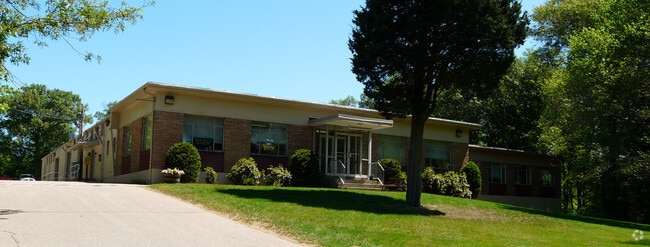
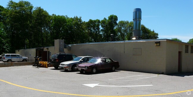
Property Record
165 Beal St, Hingham, MA 02043


Property Detail
165 Beal St
HING-000047-000000-000074
Plymouth
Warehouse
Massachusetts
B and X Area of moderate flood hazard, usually the area between the limits of the 100-year and 500-year floods.
74
2025
3.19 AC
2025
Route 3 Corridor
501102
Boston
18,142 SF
Boston-Cambridge-Newton, MA-NH
NEARBY LISTINGS FOR SALE OR LEASE
DEMOGRAPHICS near 165 Beal St
1 mile
3 mile
5 mile
2025 Total Population
7,267
51,806
155,887
2030 Population
7,553
53,141
159,969
Pop Growth 2025-2030
+ 3.94%
+ 2.58%
+ 2.62%
Average Age
46
43
43
2025 Total Households
3,199
20,752
66,090
HH Growth 2025-2030
+ 4.10%
+ 2.69%
+ 2.74%
Median Household Inc
$132,604
$119,111
$106,691
Avg Household Size
2.20
2.40
2.30
2025 Avg HH Vehicles
2.00
2.00
2.00
Median Home Value
$949,236
$740,824
$717,742
Median Year Built
1982
1956
1960
Nearby Places
Map Layers
Map Styles
 Street
 Aerial
Transit
 Traffic
 Biking
Places
Listings with unknown addresses are not visible on the map
- Restaurants
- Banks
- Shops
- Fitness
- Groceries
PUBLIC TRANSPORTATION
COMMUTER RAIL
West Hingham (Greenbush Line - Massachusetts Bay Transportation Authority Commuter Rail (Purple Line))
Drive
Walk
Distance
West Hingham (Greenbush Line - Massachusetts Bay Transportation Authority Commuter Rail (Purple Line))
4 min
1.2 mi
East Weymouth (Greenbush Line - Massachusetts Bay Transportation Authority Commuter Rail (Purple Line))
Drive
Walk
Distance
East Weymouth (Greenbush Line - Massachusetts Bay Transportation Authority Commuter Rail (Purple Line))
6 min
2.8 mi
AIRPORT
General Edward Lawrence Logan International
Drive
Walk
Distance
General Edward Lawrence Logan International
31 min
15.9 mi
Freight Ports
Port of Boston
Drive
Walk
Distance
Port of Boston
28 min
13.8 mi
Nearby Properties
Address
Land Use
TOTAL SIZE
Lot Size
Zoning
Address
Land Use
TOTAL SIZE
Lot Size
Zoning
233,488 SF
9.82 AC
Address
Land Use
TOTAL SIZE
Lot Size
Zoning
229,928 SF
3.79 AC
Address
Land Use
TOTAL SIZE
Lot Size
Zoning
617,116 SF
79.59 AC
INDB
Address
Land Use
TOTAL SIZE
Lot Size
Zoning
204,944 SF
3.83 AC
Address
Land Use
TOTAL SIZE
Lot Size
Zoning
9.94 AC
Address
Land Use
TOTAL SIZE
Lot Size
Zoning
11.39 AC
100
Address
Land Use
TOTAL SIZE
Lot Size
Zoning
231,358 SF
40.22 AC
Address
Land Use
TOTAL SIZE
Lot Size
Zoning
177,187 SF
49.76 AC
Address
Land Use
TOTAL SIZE
Lot Size
Zoning
79,687 SF
3.52 AC
75
Address
Land Use
TOTAL SIZE
Lot Size
Zoning
8.96 AC
Address
Land Use
TOTAL SIZE
Lot Size
Zoning
11.43 AC
Address
Land Use
TOTAL SIZE
Lot Size
Zoning
90,325 SF
11.64 AC
Address
Land Use
TOTAL SIZE
Lot Size
Zoning
105,024 SF
1.53 AC
Address
Land Use
TOTAL SIZE
Lot Size
Zoning
21.75 AC
100
Address
Land Use
TOTAL SIZE
Lot Size
Zoning
127,267 SF
2.96 AC
Address
Land Use
TOTAL SIZE
Lot Size
Zoning
154.20 AC
Address
Land Use
TOTAL SIZE
Lot Size
Zoning
3.76 AC
A3
Address
Land Use
TOTAL SIZE
Lot Size
Zoning
10,000 SF
21.60 AC
Address
Land Use
TOTAL SIZE
Lot Size
Zoning
78,912 SF
6.56 AC
Address
Land Use
TOTAL SIZE
Lot Size
Zoning
8.76 AC
Address
Land Use
TOTAL SIZE
Lot Size
Zoning
61.08 AC
IND
Address
Land Use
TOTAL SIZE
Lot Size
Zoning
13.31 AC
IND
Address
Land Use
TOTAL SIZE
Lot Size
Zoning
8.60 AC
Address
Land Use
TOTAL SIZE
Lot Size
Zoning
75,714 SF
4.17 AC
A3
Address
Land Use
TOTAL SIZE
Lot Size
Zoning
29,984 SF
12.14 AC
100
Address
Land Use
TOTAL SIZE
Lot Size
Zoning
8.89 AC
A3
Address
Land Use
TOTAL SIZE
Lot Size
Zoning
1,450.92 AC
Address
Land Use
TOTAL SIZE
Lot Size
Zoning
5.58 AC
A3
Address
Land Use
TOTAL SIZE
Lot Size
Zoning
472.26 AC
Address
Land Use
TOTAL SIZE
Lot Size
Zoning
9.40 AC
INDB
The World's #1 Commercial Real Estate Marketplace
Connect with us
© 2026 CoStar Group
The information above has been obtained from sources believed reliable. While we do not doubt its accuracy we have not verified it and make no guarantee, warranty or representation about it. It is your responsibility to independently confirm its accuracy and completeness. Any projections, opinions, assumptions, or estimates used are for example only and do not represent the current or future performance of the property. The value of this transaction to you depends on tax and other factors which should be evaluated by your tax, financial, and legal advisors. You and your advisors should conduct a careful, independent investigation of the property to determine to your satisfaction the suitability of the property for your needs.