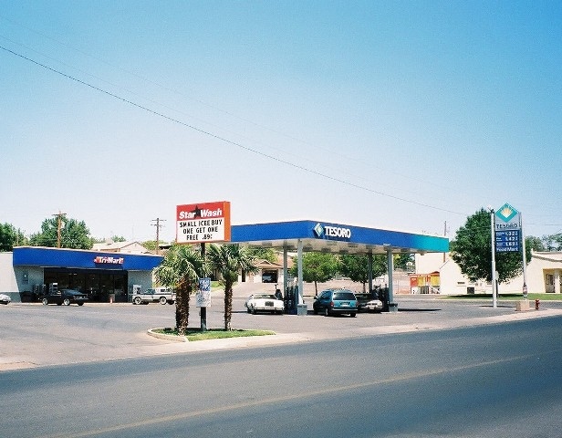
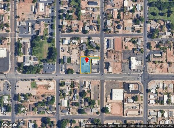
Property Record
165 E Telegraph St, Washington, UT 84780
NEARBY LISTINGS FOR SALE OR LEASE
Property Detail
165 E Telegraph St
St. George, UT
Washington Town Resrvy
0115835
SUBDIVISION: WASHINGTON TOWN RESURVEY BLK 26 (W) LOT: 1 BEG AT SE COR OF LOT 1 BLK 26 WTRS, TH N ALG BLK LN 187.0 FT; TH W 210.80 FT M/L TO W LN LOT 6 SD BLK 26; TH S 187.0 FT ALG W LN OF LOTS 1 & 6 TO SW COR SD LOT 1; TH E ALG L/L 211.46 FT M/L TO P
Commercialnec
Washington
X
Utah
49053C0794G
1
2024
0.50 AC
2025
Cedar City & St George
270805
Other Market Areas
1,536 SF
DEMOGRAPHICS near 165 E Telegraph St
1 Mile
3 Mile
5 Mile
2024 Total Population
9,334
46,017
80,701
2029 Population
11,660
57,700
100,921
Pop Growth 2024-2029
+ 24.92%
+ 25.39%
+ 25.06%
Average Age
40
40
40
2024 Total Households
3,373
16,426
27,956
HH Growth 2024-2029
+ 26.12%
+ 26.46%
+ 25.94%
Median Household Inc
$72,796
$61,724
$59,106
Avg Household Size
2.70
2.70
2.80
2024 Avg HH Vehicles
2.00
2.00
2.00
Median Home Value
$411,575
$428,052
$442,906
Median Year Built
2002
2005
2003
Nearby Places
Map Layers
Map Styles
 Street
 Aerial
- Restaurants
- Banks
- Shops
- Fitness
- Groceries
PUBLIC TRANSPORTATION
AIRPORT
St George Regional
DRIVE
WALK
Distance
St George Regional
14 min
6.8 mi
Freight Ports
Port of Long Beach
DRIVE
WALK
Distance
Port of Long Beach
446 min
406.0 mi
Nearby Properties
Address
Land Use
TOTAL SIZE
Lot Size
Zoning
Address
Land Use
TOTAL SIZE
Lot Size
Zoning
470 SF
11,422.06 AC
OSC20
Address
Land Use
TOTAL SIZE
Lot Size
Zoning
319,351 SF
31.39 AC
PD
Address
Land Use
TOTAL SIZE
Lot Size
Zoning
319,351 SF
31.39 AC
Address
Land Use
TOTAL SIZE
Lot Size
Zoning
1,319 SF
549.51 AC
Address
Land Use
TOTAL SIZE
Lot Size
Zoning
230,880 SF
25.58 AC
C-2
Address
Land Use
TOTAL SIZE
Lot Size
Zoning
87,826 SF
37.27 AC
Address
Land Use
TOTAL SIZE
Lot Size
Zoning
97,572 SF
10.51 AC
PD
Address
Land Use
TOTAL SIZE
Lot Size
Zoning
91,517 SF
8.96 AC
C2
Address
Land Use
TOTAL SIZE
Lot Size
Zoning
86,875 SF
77.53 AC
Address
Land Use
TOTAL SIZE
Lot Size
Zoning
153,140 SF
17.17 AC
C-3
Address
Land Use
TOTAL SIZE
Lot Size
Zoning
120,219 SF
11.88 AC
Address
Land Use
TOTAL SIZE
Lot Size
Zoning
67,974 SF
7.04 AC
Address
Land Use
TOTAL SIZE
Lot Size
Zoning
72,862 SF
3.20 AC
Address
Land Use
TOTAL SIZE
Lot Size
Zoning
99,566 SF
5.64 AC
Address
Land Use
TOTAL SIZE
Lot Size
Zoning
137,662 SF
7.81 AC
PD
Address
Land Use
TOTAL SIZE
Lot Size
Zoning
34,097 SF
5.90 AC
Address
Land Use
TOTAL SIZE
Lot Size
Zoning
58,937 SF
4.47 AC
C2
Address
Land Use
TOTAL SIZE
Lot Size
Zoning
111,865 SF
5 AC
M-2
Address
Land Use
TOTAL SIZE
Lot Size
Zoning
88,962 SF
8.35 AC
C-3
Address
Land Use
TOTAL SIZE
Lot Size
Zoning
115,050 SF
10.15 AC
C-2
Address
Land Use
TOTAL SIZE
Lot Size
Zoning
52,076 SF
4.81 AC
C-2
Address
Land Use
TOTAL SIZE
Lot Size
Zoning
57,335 SF
4.53 AC
Address
Land Use
TOTAL SIZE
Lot Size
Zoning
31,955 SF
5.44 AC
C-2
Address
Land Use
TOTAL SIZE
Lot Size
Zoning
36,334 SF
5.78 AC
Address
Land Use
TOTAL SIZE
Lot Size
Zoning
2,903 SF
37.45 AC
A20
Address
Land Use
TOTAL SIZE
Lot Size
Zoning
14,662 SF
31.24 AC
R110
Address
Land Use
TOTAL SIZE
Lot Size
Zoning
35,139 SF
3.85 AC
C-3
Address
Land Use
TOTAL SIZE
Lot Size
Zoning
69,835 SF
2.15 AC
C2
Address
Land Use
TOTAL SIZE
Lot Size
Zoning
188,536 SF
5.79 AC
M-2
Address
Land Use
TOTAL SIZE
Lot Size
Zoning
92,780 SF
1.92 AC
The World's #1 Commercial Real Estate Marketplace
Connect with us
© 2026 CoStar Group
The information above has been obtained from sources believed reliable. While we do not doubt its accuracy we have not verified it and make no guarantee, warranty or representation about it. It is your responsibility to independently confirm its accuracy and completeness. Any projections, opinions, assumptions, or estimates used are for example only and do not represent the current or future performance of the property. The value of this transaction to you depends on tax and other factors which should be evaluated by your tax, financial, and legal advisors. You and your advisors should conduct a careful, independent investigation of the property to determine to your satisfaction the suitability of the property for your needs.