Property Record
165 Ludlow Ave, Northvale, NJ 07647
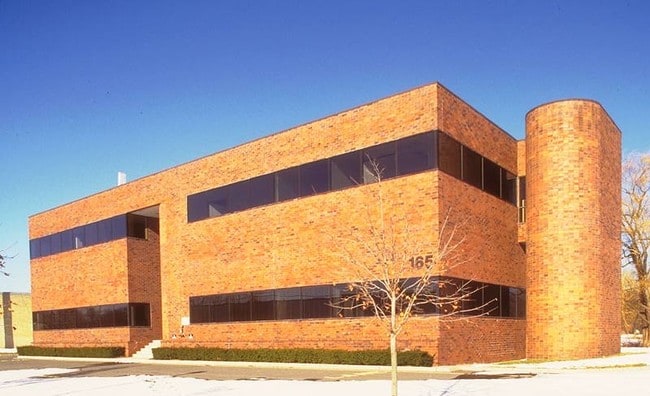

Property Detail
165 Ludlow Ave
New York-Jersey City-White Plains, NY-NJ
.93
40-01102-0000-00009
Bergen
Commercialnec
New Jersey
LI
9
AE The base floodplain where base flood elevations are provided. AE Zones are now used on new format FIRMs instead of A1-A30 Zones.
0.93 AC
2025
Northeast Bergen
2026
Northern New Jersey
002200
NEARBY LISTINGS FOR SALE OR LEASE
DEMOGRAPHICS near 165 Ludlow Ave
1 mile
3 mile
5 mile
2025 Total Population
6,284
47,825
198,883
2030 Population
6,600
49,734
204,009
Pop Growth 2025-2030
+ 5.03%
+ 3.99%
+ 2.58%
Average Age
44
43
42
2025 Total Households
2,088
16,163
70,957
HH Growth 2025-2030
+ 5.12%
+ 4.02%
+ 2.50%
Median Household Inc
$120,206
$156,535
$138,211
Avg Household Size
2.80
2.80
2.70
2025 Avg HH Vehicles
2.00
2.00
2.00
Median Home Value
$694,607
$764,343
$718,498
Median Year Built
1966
1966
1960
Nearby Places
Map Layers
Map Styles
 Street
 Aerial
Layers
 Traffic
 Biking
Places
Listings with unknown addresses are not visible on the map
- Restaurants
- Banks
- Shops
- Fitness
- Groceries
PUBLIC TRANSPORTATION
AIRPORT
Westchester County
Drive
Walk
Distance
Westchester County
38 min
24.5 mi
LaGuardia
Drive
Walk
Distance
LaGuardia
42 min
25.0 mi
Newark Liberty International
Drive
Walk
Distance
Newark Liberty International
38 min
27.6 mi
Freight Ports
NY - Red Hook Container Terminal
Drive
Walk
Distance
NY - Red Hook Container Terminal
52 min
29.8 mi
Nearby Properties
Address
Land Use
TOTAL SIZE
Lot Size
Zoning
Address
Land Use
TOTAL SIZE
Lot Size
Zoning
1,125 SF
542.62 AC
RA
Address
Land Use
TOTAL SIZE
Lot Size
Zoning
689 SF
423.72 AC
P
Address
Land Use
TOTAL SIZE
Lot Size
Zoning
289.02 AC
P
Address
Land Use
TOTAL SIZE
Lot Size
Zoning
229.55 AC
P
Address
Land Use
TOTAL SIZE
Lot Size
Zoning
185.35 AC
P
Address
Land Use
TOTAL SIZE
Lot Size
Zoning
4,000 SF
14.69 AC
Address
Land Use
TOTAL SIZE
Lot Size
Zoning
166.61 AC
P
Address
Land Use
TOTAL SIZE
Lot Size
Zoning
134.16 AC
RA
Address
Land Use
TOTAL SIZE
Lot Size
Zoning
97,600 SF
136.28 AC
R-40
Address
Land Use
TOTAL SIZE
Lot Size
Zoning
9.20 AC
OR
Address
Land Use
TOTAL SIZE
Lot Size
Zoning
191,950 SF
43.03 AC
RA25
Address
Land Use
TOTAL SIZE
Lot Size
Zoning
845.02 AC
Address
Land Use
TOTAL SIZE
Lot Size
Zoning
6.72 AC
C
Address
Land Use
TOTAL SIZE
Lot Size
Zoning
220,594 SF
22.30 AC
R-40
Address
Land Use
TOTAL SIZE
Lot Size
Zoning
4,938 SF
119 AC
Address
Land Use
TOTAL SIZE
Lot Size
Zoning
15.23 AC
C
Address
Land Use
TOTAL SIZE
Lot Size
Zoning
8.08 AC
C
Address
Land Use
TOTAL SIZE
Lot Size
Zoning
16.30 AC
LI
Address
Land Use
TOTAL SIZE
Lot Size
Zoning
8 AC
AH1CC
Address
Land Use
TOTAL SIZE
Lot Size
Zoning
161.33 AC
P
Address
Land Use
TOTAL SIZE
Lot Size
Zoning
5.96 AC
Address
Land Use
TOTAL SIZE
Lot Size
Zoning
54.65 AC
P
Address
Land Use
TOTAL SIZE
Lot Size
Zoning
35,631 SF
8.60 AC
LI
Address
Land Use
TOTAL SIZE
Lot Size
Zoning
47.14 AC
P
Address
Land Use
TOTAL SIZE
Lot Size
Zoning
6.10 AC
LI
Address
Land Use
TOTAL SIZE
Lot Size
Zoning
8.42 AC
LI
Address
Land Use
TOTAL SIZE
Lot Size
Zoning
41.23 AC
P
Address
Land Use
TOTAL SIZE
Lot Size
Zoning
48.19 AC
P
Address
Land Use
TOTAL SIZE
Lot Size
Zoning
8.25 AC
R75
Address
Land Use
TOTAL SIZE
Lot Size
Zoning
5.10 AC
C2
The World's #1 Commercial Real Estate Marketplace
Connect with us
© 2026 CoStar Group
The information above has been obtained from sources believed reliable. While we do not doubt its accuracy we have not verified it and make no guarantee, warranty or representation about it. It is your responsibility to independently confirm its accuracy and completeness. Any projections, opinions, assumptions, or estimates used are for example only and do not represent the current or future performance of the property. The value of this transaction to you depends on tax and other factors which should be evaluated by your tax, financial, and legal advisors. You and your advisors should conduct a careful, independent investigation of the property to determine to your satisfaction the suitability of the property for your needs.