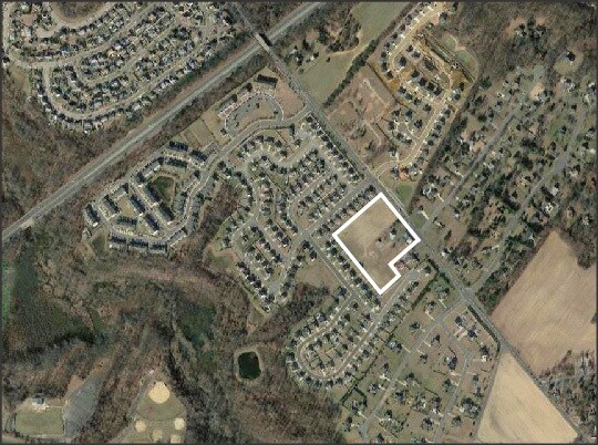
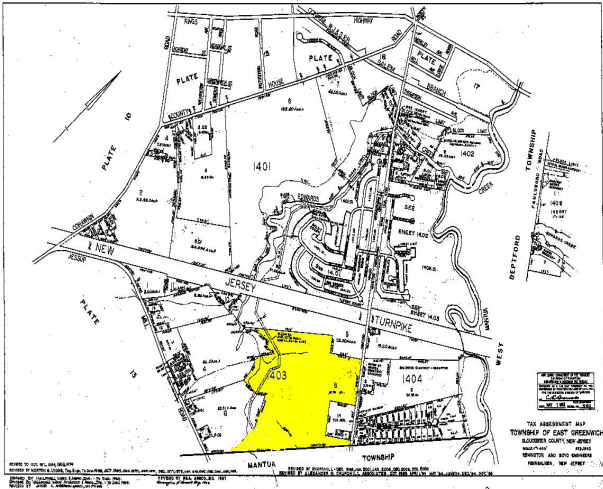
Property Record
165 Mantua Rd, Mount Royal, NJ 08061

Property Detail
165 Mantua Rd
03-01403-0000-00014
Gloucester
Farms
New Jersey
R10
14
B and X Area of moderate flood hazard, usually the area between the limits of the 100-year and 500-year floods.
0.50 AC
2024
Gloucester County
2025
Philadelphia
500601
Philadelphia-Camden-Wilmington, PA-NJ-DE-MD
2,138 SF
NEARBY LISTINGS FOR SALE OR LEASE
DEMOGRAPHICS near 165 Mantua Rd
1 mile
3 mile
5 mile
2025 Total Population
6,242
40,963
102,523
2030 Population
6,383
41,987
105,183
Pop Growth 2025-2030
+ 2.26%
+ 2.50%
+ 2.59%
Average Age
41
42
41
2025 Total Households
2,460
15,844
39,113
HH Growth 2025-2030
+ 2.40%
+ 2.58%
+ 2.63%
Median Household Inc
$107,673
$110,908
$98,952
Avg Household Size
2.50
2.60
2.60
2025 Avg HH Vehicles
2.00
2.00
2.00
Median Home Value
$381,267
$341,273
$322,175
Median Year Built
1991
1978
1974
Nearby Places
Map Layers
Map Styles
 Street
 Aerial
Transit
 Traffic
 Biking
Places
Listings with unknown addresses are not visible on the map
- Restaurants
- Banks
- Shops
- Fitness
- Groceries
PUBLIC TRANSPORTATION
AIRPORT
Philadelphia International
Drive
Walk
Distance
Philadelphia International
34 min
21.4 mi
Trenton Mercer
Drive
Walk
Distance
Trenton Mercer
71 min
47.3 mi
Atlantic City International
Drive
Walk
Distance
Atlantic City International
84 min
48.9 mi
Freight Ports
Broadway Terminal - Pier 5
Drive
Walk
Distance
Broadway Terminal - Pier 5
19 min
11.3 mi
SALE & LEASE HISTORY
LISTING DATE
SALE/LEASE

Sep 25, 2020
For Sale
Nearby Properties
Address
Land Use
TOTAL SIZE
Lot Size
Zoning
Address
Land Use
TOTAL SIZE
Lot Size
Zoning
69.05 AC
M2
Address
Land Use
TOTAL SIZE
Lot Size
Zoning
35.50 AC
R4
Address
Land Use
TOTAL SIZE
Lot Size
Zoning
32.88 AC
M1
Address
Land Use
TOTAL SIZE
Lot Size
Zoning
Address
Land Use
TOTAL SIZE
Lot Size
Zoning
22.60 AC
R4
Address
Land Use
TOTAL SIZE
Lot Size
Zoning
38.17 AC
R4
Address
Land Use
TOTAL SIZE
Lot Size
Zoning
24.27 AC
M2
Address
Land Use
TOTAL SIZE
Lot Size
Zoning
55.38 AC
M2
Address
Land Use
TOTAL SIZE
Lot Size
Zoning
111.40 AC
RRC
Address
Land Use
TOTAL SIZE
Lot Size
Zoning
36.52 AC
M1
Address
Land Use
TOTAL SIZE
Lot Size
Zoning
31 AC
M1
Address
Land Use
TOTAL SIZE
Lot Size
Zoning
19.34 AC
R1
Address
Land Use
TOTAL SIZE
Lot Size
Zoning
27.18 AC
M1
Address
Land Use
TOTAL SIZE
Lot Size
Zoning
7.01 AC
R11
Address
Land Use
TOTAL SIZE
Lot Size
Zoning
14.11 AC
SC
Address
Land Use
TOTAL SIZE
Lot Size
Zoning
30.23 AC
Address
Land Use
TOTAL SIZE
Lot Size
Zoning
34.49 AC
M1
Address
Land Use
TOTAL SIZE
Lot Size
Zoning
14.14 AC
R11
Address
Land Use
TOTAL SIZE
Lot Size
Zoning
12.73 AC
Address
Land Use
TOTAL SIZE
Lot Size
Zoning
28.70 AC
M1
Address
Land Use
TOTAL SIZE
Lot Size
Zoning
4.47 AC
MU
Address
Land Use
TOTAL SIZE
Lot Size
Zoning
10.39 AC
RRC
Address
Land Use
TOTAL SIZE
Lot Size
Zoning
2.62 AC
Address
Land Use
TOTAL SIZE
Lot Size
Zoning
14.66 AC
M1
Address
Land Use
TOTAL SIZE
Lot Size
Zoning
18.21 AC
M1
Address
Land Use
TOTAL SIZE
Lot Size
Zoning
27.40 AC
LI
Address
Land Use
TOTAL SIZE
Lot Size
Zoning
13,221 SF
9.92 AC
HC
Address
Land Use
TOTAL SIZE
Lot Size
Zoning
11.51 AC
Address
Land Use
TOTAL SIZE
Lot Size
Zoning
15.24 AC
Address
Land Use
TOTAL SIZE
Lot Size
Zoning
12.30 AC
R1
The World's #1 Commercial Real Estate Marketplace
Connect with us
© 2026 CoStar Group
The information above has been obtained from sources believed reliable. While we do not doubt its accuracy we have not verified it and make no guarantee, warranty or representation about it. It is your responsibility to independently confirm its accuracy and completeness. Any projections, opinions, assumptions, or estimates used are for example only and do not represent the current or future performance of the property. The value of this transaction to you depends on tax and other factors which should be evaluated by your tax, financial, and legal advisors. You and your advisors should conduct a careful, independent investigation of the property to determine to your satisfaction the suitability of the property for your needs.