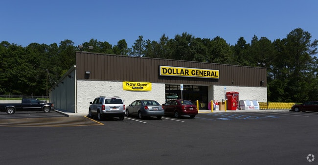
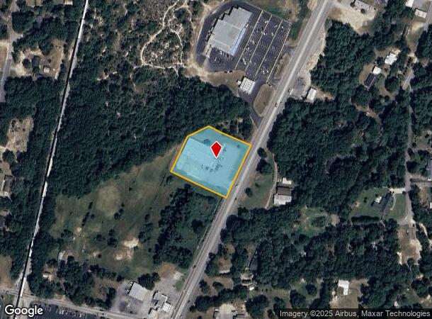
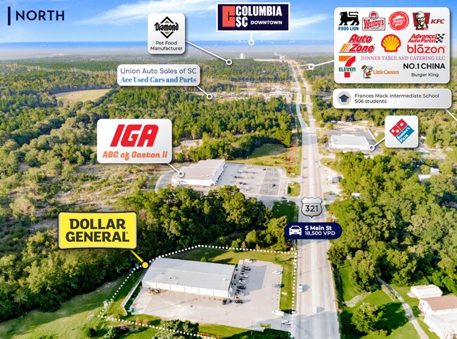
Property Record
165 N Main St, Gaston, SC 29053

NEARBY LISTINGS FOR SALE OR LEASE
-
-
View all Gaston listings for sale on LoopNet.com
Property Detail
165 N Main St
010117-05-040
Prepared For Jr Lex Llc
Commercialnec
NORTHERN PORTIONS OF PARCELS 3 & 4
X
Lexington
45063C0405J
South Carolina
2025
1.62 AC
2024
Cayce/West Columbia
020806
Columbia
12,400 SF
Columbia, SC
DEMOGRAPHICS near 165 N Main St
1 mile
3 mile
5 mile
2024 Total Population
1,629
9,804
22,106
2029 Population
1,802
10,855
24,409
Pop Growth 2024-2029
+ 10.62%
+ 10.72%
+ 10.42%
Average Age
39
38
39
2024 Total Households
592
3,571
8,159
HH Growth 2024-2029
+ 10.64%
+ 10.89%
+ 10.53%
Median Household Inc
$41,990
$41,055
$44,298
Avg Household Size
2.60
2.60
2.60
2024 Avg HH Vehicles
2.00
2.00
2.00
Median Home Value
$77,603
$86,800
$96,808
Median Year Built
1991
1993
1992
Nearby Places
Map Layers
Map Styles
 Street
 Aerial
Transit
 Traffic
 Biking
Places
Listings with unknown addresses are not visible on the map
- Restaurants
- Banks
- Shops
- Fitness
- Groceries
PUBLIC TRANSPORTATION
AIRPORT
Columbia Metro
Drive
Walk
Distance
Columbia Metro
26 min
15.1 mi
SALE & LEASE HISTORY
LISTING DATE
SALE/LEASE

Oct 03, 2022
For Sale
Feb 24, 2023
For Sale
Nearby Properties
Address
Land Use
TOTAL SIZE
Lot Size
Zoning
Address
Land Use
TOTAL SIZE
Lot Size
Zoning
39,216 SF
271.81 AC
ID
Address
Land Use
TOTAL SIZE
Lot Size
Zoning
9,180 SF
10.66 AC
Address
Land Use
TOTAL SIZE
Lot Size
Zoning
7,150 SF
2.46 AC
Address
Land Use
TOTAL SIZE
Lot Size
Zoning
5,880 SF
1.02 AC
Address
Land Use
TOTAL SIZE
Lot Size
Zoning
6,840 SF
0.82 AC
Address
Land Use
TOTAL SIZE
Lot Size
Zoning
18,358 SF
1.75 AC
RD
Address
Land Use
TOTAL SIZE
Lot Size
Zoning
3,360 SF
1.34 AC
RD
Address
Land Use
TOTAL SIZE
Lot Size
Zoning
23,387 SF
8.32 AC
ID
Address
Land Use
TOTAL SIZE
Lot Size
Zoning
5,828 SF
2.04 AC
Address
Land Use
TOTAL SIZE
Lot Size
Zoning
800 SF
418.19 AC
RD
Address
Land Use
TOTAL SIZE
Lot Size
Zoning
27.47 AC
ID
Address
Land Use
TOTAL SIZE
Lot Size
Zoning
1,216 SF
10.52 AC
RD
Address
Land Use
TOTAL SIZE
Lot Size
Zoning
3,153 SF
1 AC
Address
Land Use
TOTAL SIZE
Lot Size
Zoning
1,216 SF
7.47 AC
RD
Address
Land Use
TOTAL SIZE
Lot Size
Zoning
18,225 SF
2.37 AC
LR
Address
Land Use
TOTAL SIZE
Lot Size
Zoning
152.38 AC
LR
Address
Land Use
TOTAL SIZE
Lot Size
Zoning
2,400 SF
12 AC
RD
Address
Land Use
TOTAL SIZE
Lot Size
Zoning
134.04 AC
LR
Address
Land Use
TOTAL SIZE
Lot Size
Zoning
1,008 SF
9.82 AC
RD
Address
Land Use
TOTAL SIZE
Lot Size
Zoning
10,986 SF
187.28 AC
LR
Address
Land Use
TOTAL SIZE
Lot Size
Zoning
1.64 AC
Address
Land Use
TOTAL SIZE
Lot Size
Zoning
5,000 SF
3.43 AC
Address
Land Use
TOTAL SIZE
Lot Size
Zoning
6,791 SF
0.85 AC
Address
Land Use
TOTAL SIZE
Lot Size
Zoning
3,140 SF
0.99 AC
Address
Land Use
TOTAL SIZE
Lot Size
Zoning
2,400 SF
1.43 AC
LR
Address
Land Use
TOTAL SIZE
Lot Size
Zoning
7,075 SF
239.23 AC
RD
Address
Land Use
TOTAL SIZE
Lot Size
Zoning
176 AC
LR
Address
Land Use
TOTAL SIZE
Lot Size
Zoning
1,500 SF
2.34 AC
LR
Address
Land Use
TOTAL SIZE
Lot Size
Zoning
3,612 SF
1.01 AC
RD
The World's #1 Commercial Real Estate Marketplace
Connect with us
© 2026 CoStar Group
The information above has been obtained from sources believed reliable. While we do not doubt its accuracy we have not verified it and make no guarantee, warranty or representation about it. It is your responsibility to independently confirm its accuracy and completeness. Any projections, opinions, assumptions, or estimates used are for example only and do not represent the current or future performance of the property. The value of this transaction to you depends on tax and other factors which should be evaluated by your tax, financial, and legal advisors. You and your advisors should conduct a careful, independent investigation of the property to determine to your satisfaction the suitability of the property for your needs.