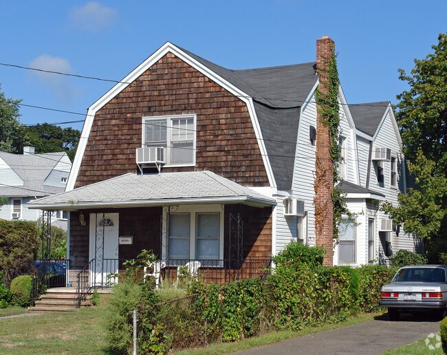
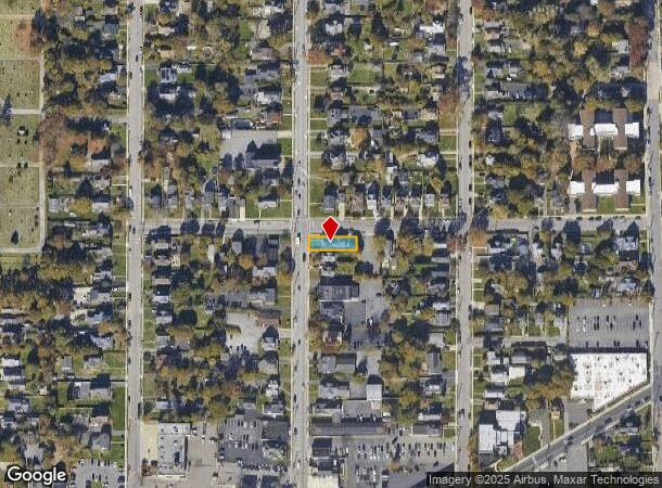
Property Record
165 N Ocean Ave, Patchogue, NY 11772
This Property Is For Sale
NEARBY LISTINGS FOR SALE OR LEASE
Property Detail
165 N Ocean Ave
Nassau County-Suffolk County, NY
Patchogue (A To L)
0204-009-00-03-00-007-000
N THORNE ST E HALL & ANO S UNDERWOO
Sfr
Suffolk
X
New York
36103C0694H
7
2024
0.12 AC
2024
Central Suffolk
158902
Long Island (New York)
1,270 SF
DEMOGRAPHICS near 165 N Ocean Ave
1 mile
3 mile
5 mile
2024 Total Population
13,036
70,267
157,417
2029 Population
12,785
69,475
155,827
Pop Growth 2024-2029
(1.93%)
(1.13%)
(1.01%)
Average Age
41
42
42
2024 Total Households
5,137
26,535
55,748
HH Growth 2024-2029
(2.14%)
(1.32%)
(1.22%)
Median Household Inc
$92,762
$106,261
$110,433
Avg Household Size
2.40
2.50
2.70
2024 Avg HH Vehicles
2.00
2.00
2.00
Median Home Value
$402,120
$453,178
$454,587
Median Year Built
1962
1972
1973
Nearby Places
Map Layers
Map Styles
 Street
 Aerial
Transit
 Traffic
 Biking
Places
Listings with unknown addresses are not visible on the map
- Restaurants
- Banks
- Shops
- Fitness
- Groceries
PUBLIC TRANSPORTATION
TRANSIT/SUBWAY
Patchogue Station (Montauk Branch - Long Island Rail Road)
Drive
Walk
Distance
Patchogue Station (Montauk Branch - Long Island Rail Road)
2 min
13 min
0.7 mi
COMMUTER RAIL
Patchogue Station (Montauk Branch - Long Island Rail Road)
Drive
Walk
Distance
Patchogue Station (Montauk Branch - Long Island Rail Road)
2 min
12 min
0.6 mi
Medford Station (Greenport Branch - Long Island Rail Road)
Drive
Walk
Distance
Medford Station (Greenport Branch - Long Island Rail Road)
8 min
3.9 mi
AIRPORT
Long Island MacArthur
Drive
Walk
Distance
Long Island MacArthur
13 min
6.3 mi
Nearby Properties
Address
Land Use
TOTAL SIZE
Lot Size
Zoning
Address
Land Use
TOTAL SIZE
Lot Size
Zoning
30.25 AC
CA
Address
Land Use
TOTAL SIZE
Lot Size
Zoning
33.47 AC
AA
Address
Land Use
TOTAL SIZE
Lot Size
Zoning
3,060 SF
0.22 AC
VILLA
Address
Land Use
TOTAL SIZE
Lot Size
Zoning
29.86 AC
CA
Address
Land Use
TOTAL SIZE
Lot Size
Zoning
26.28 AC
CA
Address
Land Use
TOTAL SIZE
Lot Size
Zoning
7,290 SF
15.71 AC
CA
Address
Land Use
TOTAL SIZE
Lot Size
Zoning
3,034 SF
0.20 AC
VILLA
Address
Land Use
TOTAL SIZE
Lot Size
Zoning
2,196 SF
0.33 AC
VILLA
Address
Land Use
TOTAL SIZE
Lot Size
Zoning
4,220 SF
2.07 AC
R15
Address
Land Use
TOTAL SIZE
Lot Size
Zoning
3,766 SF
0.59 AC
R15
Address
Land Use
TOTAL SIZE
Lot Size
Zoning
4,446 SF
1.17 AC
CR200
Address
Land Use
TOTAL SIZE
Lot Size
Zoning
96 SF
18.29 AC
BUS3
Address
Land Use
TOTAL SIZE
Lot Size
Zoning
3,025 SF
5.60 AC
AA
Address
Land Use
TOTAL SIZE
Lot Size
Zoning
23.90 AC
AA
Address
Land Use
TOTAL SIZE
Lot Size
Zoning
5,858 SF
1.73 AC
R40
Address
Land Use
TOTAL SIZE
Lot Size
Zoning
2,724 SF
0.32 AC
VILLA
Address
Land Use
TOTAL SIZE
Lot Size
Zoning
4,000 SF
0.30 AC
VILLA
Address
Land Use
TOTAL SIZE
Lot Size
Zoning
2,046 SF
0.21 AC
VILLA
Address
Land Use
TOTAL SIZE
Lot Size
Zoning
12.70 AC
IND1
Address
Land Use
TOTAL SIZE
Lot Size
Zoning
5.01 AC
AA278
Address
Land Use
TOTAL SIZE
Lot Size
Zoning
42.37 AC
Address
Land Use
TOTAL SIZE
Lot Size
Zoning
6,968 SF
1.15 AC
R40
Address
Land Use
TOTAL SIZE
Lot Size
Zoning
4,225 SF
1.02 AC
R40
Address
Land Use
TOTAL SIZE
Lot Size
Zoning
12.14 AC
BUS3
Address
Land Use
TOTAL SIZE
Lot Size
Zoning
14.73 AC
AA
Address
Land Use
TOTAL SIZE
Lot Size
Zoning
2,554 SF
0.50 AC
VILLA
Address
Land Use
TOTAL SIZE
Lot Size
Zoning
4,103 SF
1.16 AC
VILLA
Address
Land Use
TOTAL SIZE
Lot Size
Zoning
19.70 AC
AA
Address
Land Use
TOTAL SIZE
Lot Size
Zoning
2,035 SF
0.15 AC
VILLA
Address
Land Use
TOTAL SIZE
Lot Size
Zoning
14.70 AC
BUS3
The World's #1 Commercial Real Estate Marketplace
Connect with us
© 2026 CoStar Group
The information above has been obtained from sources believed reliable. While we do not doubt its accuracy we have not verified it and make no guarantee, warranty or representation about it. It is your responsibility to independently confirm its accuracy and completeness. Any projections, opinions, assumptions, or estimates used are for example only and do not represent the current or future performance of the property. The value of this transaction to you depends on tax and other factors which should be evaluated by your tax, financial, and legal advisors. You and your advisors should conduct a careful, independent investigation of the property to determine to your satisfaction the suitability of the property for your needs.