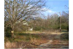
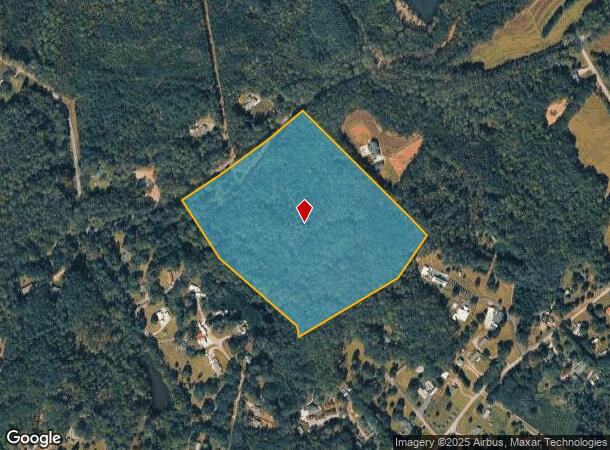
Property Record
165 N Watson Rd, Easley, SC 29642
NEARBY LISTINGS FOR SALE OR LEASE
-
-
View all Easley listings for sale on LoopNet.com
Property Detail
165 N Watson Rd
5027-00-22-8045
S/SIDE N WATSON RD PLAT FILED BY PIN NUMBER, PLAT 605/178. P/O IN PICKENS & P/O IN ANDERSON
Vacantlandnec
Pickens
X
South Carolina
45007C0040E
28.45 AC
2025
Outlying Pickens County
2024
Greenville/Spartanburg
010901
Greenville-Anderson-Mauldin, SC
DEMOGRAPHICS near 165 N Watson Rd
1 Mile
3 Mile
5 Mile
2024 Total Population
1,498
18,495
52,354
2029 Population
1,592
19,573
55,084
Pop Growth 2024-2029
+ 6.28%
+ 5.83%
+ 5.21%
Average Age
41
41
41
2024 Total Households
535
7,006
20,553
HH Growth 2024-2029
+ 6.36%
+ 5.87%
+ 5.25%
Median Household Inc
$69,699
$68,215
$62,860
Avg Household Size
2.70
2.60
2.50
2024 Avg HH Vehicles
2.00
2.00
2.00
Median Home Value
$219,412
$222,433
$212,187
Median Year Built
1994
1992
1990
Nearby Places
Map Layers
Map Styles
 Street
 Aerial
- Restaurants
- Banks
- Shops
- Fitness
- Groceries
PUBLIC TRANSPORTATION
AIRPORT
Greenville Spartanburg International
DRIVE
WALK
Distance
Greenville Spartanburg International
46 min
30.9 mi
Freight Ports
North Charleston Terminal
DRIVE
WALK
Distance
North Charleston Terminal
249 min
215.1 mi
Nearby Properties
Address
Land Use
TOTAL SIZE
Lot Size
Zoning
Address
Land Use
TOTAL SIZE
Lot Size
Zoning
162.06 AC
R10
Address
Land Use
TOTAL SIZE
Lot Size
Zoning
177,695 SF
20.43 AC
Address
Land Use
TOTAL SIZE
Lot Size
Zoning
9,800 SF
5.94 AC
R10
Address
Land Use
TOTAL SIZE
Lot Size
Zoning
27.43 AC
R 10 ONE F
Address
Land Use
TOTAL SIZE
Lot Size
Zoning
55 AC
R 10 ONE F
Address
Land Use
TOTAL SIZE
Lot Size
Zoning
3,161 SF
0.34 AC
GENERAL RE
Address
Land Use
TOTAL SIZE
Lot Size
Zoning
1,904 SF
17.74 AC
R10
Address
Land Use
TOTAL SIZE
Lot Size
Zoning
8.03 AC
IND
Address
Land Use
TOTAL SIZE
Lot Size
Zoning
38.67 AC
R10
Address
Land Use
TOTAL SIZE
Lot Size
Zoning
200 SF
10.92 AC
GENERAL CO
Address
Land Use
TOTAL SIZE
Lot Size
Zoning
1,800 SF
6.23 AC
Address
Land Use
TOTAL SIZE
Lot Size
Zoning
135,024 SF
10.50 AC
RM 2 TWO F
Address
Land Use
TOTAL SIZE
Lot Size
Zoning
13.60 AC
Address
Land Use
TOTAL SIZE
Lot Size
Zoning
1.68 AC
GENERAL RE
Address
Land Use
TOTAL SIZE
Lot Size
Zoning
3.75 AC
R10
Address
Land Use
TOTAL SIZE
Lot Size
Zoning
9.05 AC
R 10 ONE F
Address
Land Use
TOTAL SIZE
Lot Size
Zoning
29.07 AC
Address
Land Use
TOTAL SIZE
Lot Size
Zoning
8,480 SF
2.66 AC
R10
Address
Land Use
TOTAL SIZE
Lot Size
Zoning
41.48 AC
GC
Address
Land Use
TOTAL SIZE
Lot Size
Zoning
18,896 SF
9.03 AC
GR2
Address
Land Use
TOTAL SIZE
Lot Size
Zoning
1.75 AC
GENERAL RE
Address
Land Use
TOTAL SIZE
Lot Size
Zoning
41 AC
U
Address
Land Use
TOTAL SIZE
Lot Size
Zoning
1,386 SF
3.03 AC
GC
Address
Land Use
TOTAL SIZE
Lot Size
Zoning
131 SF
GENERAL CO
Address
Land Use
TOTAL SIZE
Lot Size
Zoning
2.80 AC
Address
Land Use
TOTAL SIZE
Lot Size
Zoning
2.28 AC
GC
Address
Land Use
TOTAL SIZE
Lot Size
Zoning
125 AC
Address
Land Use
TOTAL SIZE
Lot Size
Zoning
1.48 AC
R10
Address
Land Use
TOTAL SIZE
Lot Size
Zoning
2,460 SF
7.39 AC
The World's #1 Commercial Real Estate Marketplace
Connect with us
© 2025 CoStar Group
The information above has been obtained from sources believed reliable. While we do not doubt its accuracy we have not verified it and make no guarantee, warranty or representation about it. It is your responsibility to independently confirm its accuracy and completeness. Any projections, opinions, assumptions, or estimates used are for example only and do not represent the current or future performance of the property. The value of this transaction to you depends on tax and other factors which should be evaluated by your tax, financial, and legal advisors. You and your advisors should conduct a careful, independent investigation of the property to determine to your satisfaction the suitability of the property for your needs.