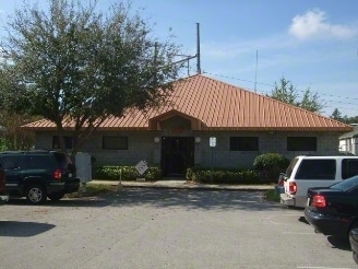
Property Record
165 Sabal Palm Dr, Longwood, FL 32779


Current Lease Availabilities
NEARBY LISTINGS FOR SALE OR LEASE
Property Detail
165 Sabal Palm Dr
33-20-29-515-0000-0040
Sabal Square Condo At Sabal Point 1 St R
Officecondo
UNIT 4 SABAL SQUARE CONDO AT SABAL POINT 1 ST REV PB 27 PGS 78 & 79
X
Seminole
12095C0150F
Florida
2025
0.08 AC
2025
Longwood
021609
Orlando
3,388 SF
Orlando-Kissimmee-Sanford, FL
DEMOGRAPHICS near 165 Sabal Palm Dr
1 Mile
3 Mile
5 Mile
2024 Total Population
9,368
59,938
169,981
2029 Population
9,776
62,419
176,616
Pop Growth 2024-2029
+ 4.36%
+ 4.14%
+ 3.90%
Average Age
43
42
42
2024 Total Households
3,842
24,108
68,441
HH Growth 2024-2029
+ 4.53%
+ 4.36%
+ 4.10%
Median Household Inc
$93,449
$75,012
$68,387
Avg Household Size
2.40
2.40
2.40
2024 Avg HH Vehicles
2.00
2.00
2.00
Median Home Value
$422,923
$353,809
$330,048
Median Year Built
1984
1981
1984
Nearby Places
Map Layers
Map Styles
 Street
 Aerial
- Restaurants
- Banks
- Shops
- Fitness
- Groceries
PUBLIC TRANSPORTATION
COMMUTER RAIL
DRIVE
WALK
Distance
12 min
6.0 mi
DRIVE
WALK
Distance
13 min
6.2 mi
AIRPORT
Orlando Sanford International
DRIVE
WALK
Distance
Orlando Sanford International
28 min
16.3 mi
Orlando International
DRIVE
WALK
Distance
Orlando International
41 min
25.8 mi
Daytona Beach International
DRIVE
WALK
Distance
Daytona Beach International
56 min
44.3 mi
Freight Ports
Port Canaveral
DRIVE
WALK
Distance
Port Canaveral
87 min
67.8 mi
Nearby Properties
Address
Land Use
TOTAL SIZE
Lot Size
Zoning
Address
Land Use
TOTAL SIZE
Lot Size
Zoning
745,187 SF
18 AC
PUD
Address
Land Use
TOTAL SIZE
Lot Size
Zoning
130,246 SF
71.01 AC
PUD
Address
Land Use
TOTAL SIZE
Lot Size
Zoning
391,714 SF
42.59 AC
A1
Address
Land Use
TOTAL SIZE
Lot Size
Zoning
1,416 SF
23.80 AC
Address
Land Use
TOTAL SIZE
Lot Size
Zoning
Address
Land Use
TOTAL SIZE
Lot Size
Zoning
5,256 SF
1.10 AC
PUDRES
Address
Land Use
TOTAL SIZE
Lot Size
Zoning
269,555 SF
214.60 AC
PUD
Address
Land Use
TOTAL SIZE
Lot Size
Zoning
1,170 SF
17.75 AC
A1
Address
Land Use
TOTAL SIZE
Lot Size
Zoning
5,924 SF
17.38 AC
R1A
Address
Land Use
TOTAL SIZE
Lot Size
Zoning
3,658 SF
17.71 AC
PUD
Address
Land Use
TOTAL SIZE
Lot Size
Zoning
442,334 SF
23.80 AC
A1
Address
Land Use
TOTAL SIZE
Lot Size
Zoning
3,140 SF
15.89 AC
PUD
Address
Land Use
TOTAL SIZE
Lot Size
Zoning
3,370 SF
18.59 AC
PUD
Address
Land Use
TOTAL SIZE
Lot Size
Zoning
279,457 SF
20.56 AC
R3
Address
Land Use
TOTAL SIZE
Lot Size
Zoning
3,854 SF
14.33 AC
PUD
Address
Land Use
TOTAL SIZE
Lot Size
Zoning
194,651 SF
13.14 AC
R3
Address
Land Use
TOTAL SIZE
Lot Size
Zoning
26,157 SF
18.63 AC
CG
Address
Land Use
TOTAL SIZE
Lot Size
Zoning
172,213 SF
7.16 AC
R3
Address
Land Use
TOTAL SIZE
Lot Size
Zoning
83,209 SF
5,971.65 AC
A-2
Address
Land Use
TOTAL SIZE
Lot Size
Zoning
8,975 SF
13.13 AC
C1
Address
Land Use
TOTAL SIZE
Lot Size
Zoning
253,035 SF
16.12 AC
MOR2
Address
Land Use
TOTAL SIZE
Lot Size
Zoning
Address
Land Use
TOTAL SIZE
Lot Size
Zoning
182,347 SF
19.38 AC
IN
Address
Land Use
TOTAL SIZE
Lot Size
Zoning
208,035 SF
3.41 AC
MOR3
Address
Land Use
TOTAL SIZE
Lot Size
Zoning
92,048 SF
7.91 AC
C1
Address
Land Use
TOTAL SIZE
Lot Size
Zoning
95,971 SF
4.34 AC
MOI2
Address
Land Use
TOTAL SIZE
Lot Size
Zoning
114,738 SF
10.99 AC
CG
Address
Land Use
TOTAL SIZE
Lot Size
Zoning
144,245 SF
16.20 AC
PUDMO
Address
Land Use
TOTAL SIZE
Lot Size
Zoning
26,830 SF
13.37 AC
R3
Address
Land Use
TOTAL SIZE
Lot Size
Zoning
158,378 SF
13.11 AC
The World's #1 Commercial Real Estate Marketplace
Connect with us
© 2026 CoStar Group
The information above has been obtained from sources believed reliable. While we do not doubt its accuracy we have not verified it and make no guarantee, warranty or representation about it. It is your responsibility to independently confirm its accuracy and completeness. Any projections, opinions, assumptions, or estimates used are for example only and do not represent the current or future performance of the property. The value of this transaction to you depends on tax and other factors which should be evaluated by your tax, financial, and legal advisors. You and your advisors should conduct a careful, independent investigation of the property to determine to your satisfaction the suitability of the property for your needs.