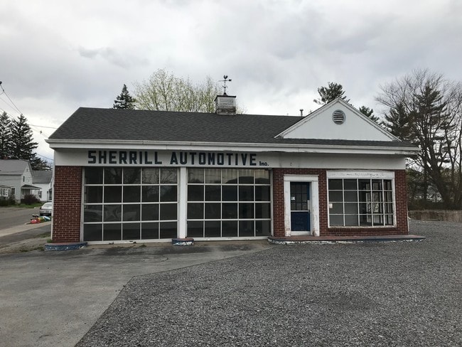
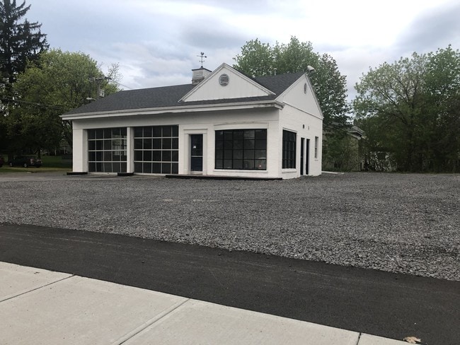
Property Record
165 Sherrill Rd, Sherrill, NY 13461

NEARBY LISTINGS FOR SALE OR LEASE
Property Detail
165 Sherrill Rd
322-015-0002-051-000-0000
GAR & GAS STA
Servicestation
Oneida
X
New York
36065C0678F
51.000
2024
Outlying Oneida County
2024
Utica/Rome
024800
Utica-Rome, NY
1,260 SF
DEMOGRAPHICS near 165 Sherrill Rd
1 Mile
3 Mile
5 Mile
2024 Total Population
3,204
9,965
19,645
2029 Population
3,150
9,728
19,194
Pop Growth 2024-2029
(1.69%)
(2.38%)
(2.30%)
Average Age
45
44
43
2024 Total Households
1,409
4,327
8,411
HH Growth 2024-2029
(1.85%)
(2.52%)
(2.43%)
Median Household Inc
$76,798
$69,545
$63,463
Avg Household Size
2.30
2.30
2.30
2024 Avg HH Vehicles
2.00
2.00
2.00
Median Home Value
$184,143
$167,073
$161,323
Median Year Built
1951
1949
1953
Nearby Places
- Restaurants
- Banks
- Shops
- Fitness
- Groceries
PUBLIC TRANSPORTATION
AIRPORT
Syracuse Hancock International
DRIVE
WALK
Distance
Syracuse Hancock International
50 min
35.2 mi
Freight Ports
Albany, NY Port
DRIVE
WALK
Distance
Albany, NY Port
144 min
119.5 mi
SALE & LEASE HISTORY
LISTING DATE
SALE/LEASE

Aug 28, 2020
For Sale
Apr 23, 2019
For Lease
Nearby Properties
Address
Land Use
TOTAL SIZE
Lot Size
Zoning
Address
Land Use
TOTAL SIZE
Lot Size
Zoning
132,207 SF
4.14 AC
CS
Address
Land Use
TOTAL SIZE
Lot Size
Zoning
71,138 SF
14.10 AC
CS
Address
Land Use
TOTAL SIZE
Lot Size
Zoning
26,158 SF
19.28 AC
LI
Address
Land Use
TOTAL SIZE
Lot Size
Zoning
1.24 AC
01
Address
Land Use
TOTAL SIZE
Lot Size
Zoning
1,252 SF
44.93 AC
R1
Address
Land Use
TOTAL SIZE
Lot Size
Zoning
2,418 SF
55.37 AC
R1
Address
Land Use
TOTAL SIZE
Lot Size
Zoning
29,762 SF
6.75 AC
C
Address
Land Use
TOTAL SIZE
Lot Size
Zoning
28,350 SF
142.35 AC
A
Address
Land Use
TOTAL SIZE
Lot Size
Zoning
Address
Land Use
TOTAL SIZE
Lot Size
Zoning
215,981 SF
12.90 AC
C
Address
Land Use
TOTAL SIZE
Lot Size
Zoning
49,029 SF
12 AC
CS
Address
Land Use
TOTAL SIZE
Lot Size
Zoning
21,150 SF
3.74 AC
Address
Land Use
TOTAL SIZE
Lot Size
Zoning
48,000 SF
4.58 AC
04 - FARM
Address
Land Use
TOTAL SIZE
Lot Size
Zoning
Address
Land Use
TOTAL SIZE
Lot Size
Zoning
109,750 SF
12.98 AC
C
Address
Land Use
TOTAL SIZE
Lot Size
Zoning
42,454 SF
12.07 AC
01 - NOT Z
Address
Land Use
TOTAL SIZE
Lot Size
Zoning
56,914 SF
3.83 AC
C
Address
Land Use
TOTAL SIZE
Lot Size
Zoning
205,242 SF
34.07 AC
Address
Land Use
TOTAL SIZE
Lot Size
Zoning
205,242 SF
46.75 AC
Address
Land Use
TOTAL SIZE
Lot Size
Zoning
205,242 SF
46.75 AC
Address
Land Use
TOTAL SIZE
Lot Size
Zoning
17,600 SF
2.76 AC
R2
Address
Land Use
TOTAL SIZE
Lot Size
Zoning
4.66 AC
C
Address
Land Use
TOTAL SIZE
Lot Size
Zoning
33,675 SF
6.50 AC
01 - NOT Z
Address
Land Use
TOTAL SIZE
Lot Size
Zoning
33,675 SF
6.50 AC
01 - NOT Z
Address
Land Use
TOTAL SIZE
Lot Size
Zoning
48.42 AC
Address
Land Use
TOTAL SIZE
Lot Size
Zoning
246,600 SF
48.42 AC
01 - NOT Z
Address
Land Use
TOTAL SIZE
Lot Size
Zoning
31,877 SF
1.56 AC
01 - NOT Z
Address
Land Use
TOTAL SIZE
Lot Size
Zoning
21,072 SF
1.38 AC
DC
Address
Land Use
TOTAL SIZE
Lot Size
Zoning
15,752 SF
9.12 AC
Address
Land Use
TOTAL SIZE
Lot Size
Zoning
15,752 SF
9.12 AC
The World's #1 Commercial Real Estate Marketplace
Connect with us
© 2025 CoStar Group
The information above has been obtained from sources believed reliable. While we do not doubt its accuracy we have not verified it and make no guarantee, warranty or representation about it. It is your responsibility to independently confirm its accuracy and completeness. Any projections, opinions, assumptions, or estimates used are for example only and do not represent the current or future performance of the property. The value of this transaction to you depends on tax and other factors which should be evaluated by your tax, financial, and legal advisors. You and your advisors should conduct a careful, independent investigation of the property to determine to your satisfaction the suitability of the property for your needs.